Junction Topo Map Ohio
To zoom in, hover over the map of Junction
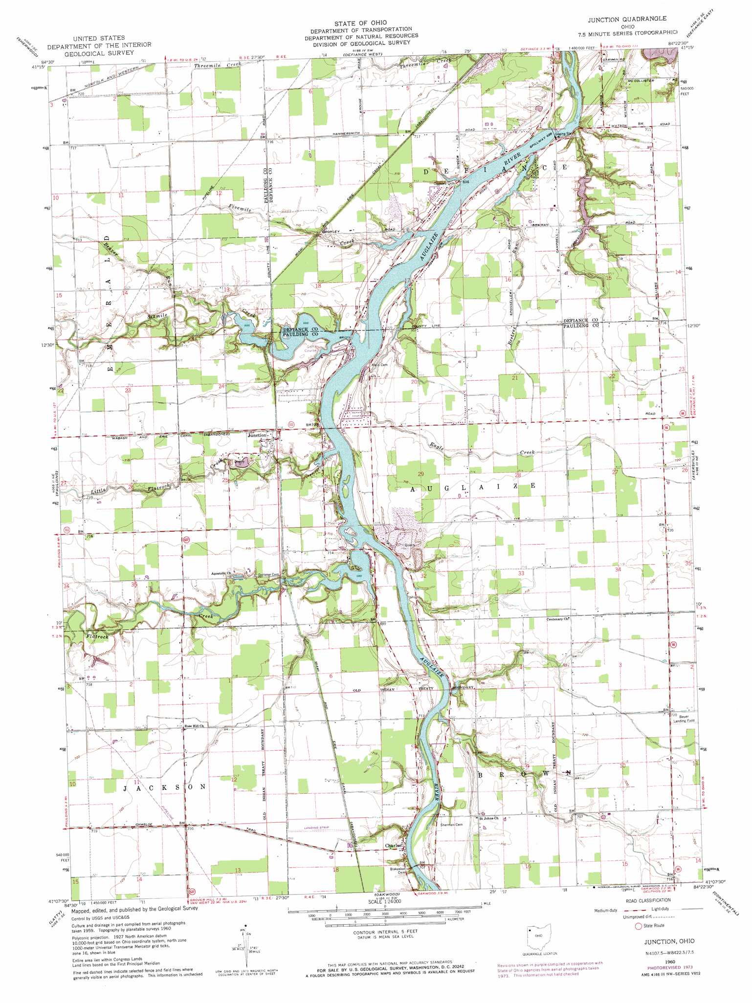
USGS Topo Quad 41084b4 - 1:24,000 scale
| Topo Map Name: | Junction |
| USGS Topo Quad ID: | 41084b4 |
| Print Size: | ca. 21 1/4" wide x 27" high |
| Southeast Coordinates: | 41.125° N latitude / 84.375° W longitude |
| Map Center Coordinates: | 41.1875° N latitude / 84.4375° W longitude |
| U.S. State: | OH |
| Filename: | o41084b4.jpg |
| Download Map JPG Image: | Junction topo map 1:24,000 scale |
| Map Type: | Topographic |
| Topo Series: | 7.5´ |
| Map Scale: | 1:24,000 |
| Source of Map Images: | United States Geological Survey (USGS) |
| Alternate Map Versions: |
Junction OH 1960, updated 1961 Download PDF Buy paper map Junction OH 1960, updated 1974 Download PDF Buy paper map Junction OH 2010 Download PDF Buy paper map Junction OH 2013 Download PDF Buy paper map Junction OH 2016 Download PDF Buy paper map |
1:24,000 Topo Quads surrounding Junction
Edgerton |
Bryan |
Evansport |
Ridgeville Corners |
Napoleon West |
Mark Center |
Sherwood |
Defiance West |
Defiance East |
Florida |
Antwerp |
Paulding |
Junction |
Ayersville |
New Bavaria |
Payne |
Latty |
Oakwood |
Continental |
Miller City |
Convoy |
Scott |
Wetsel |
Ottoville |
Kalida |
> Back to 41084a1 at 1:100,000 scale
> Back to 41084a1 at 1:250,000 scale
> Back to U.S. Topo Maps home
Junction topo map: Gazetteer
Junction: Airports
Charloe Airport elevation 217m 711′Junction: Canals
Jackson Ditch elevation 210m 688′Junction: Dams
Kohart Lake Dam elevation 206m 675′Toledo Edison Power Dam elevation 202m 662′
Junction: Mines
Auglaize Quarry elevation 216m 708′Junction: Parks
Charloe Community Park elevation 217m 711′Junction: Populated Places
Ball Subdivision elevation 214m 702′Charloe elevation 217m 711′
Junction elevation 217m 711′
Molasses Gap elevation 218m 715′
Renollet (historical) elevation 219m 718′
Junction: Post Offices
Charloe Post Office (historical) elevation 218m 715′Junction Post Office (historical) elevation 217m 711′
Junction: Reservoirs
Defiance Reservoir elevation 202m 662′Kohart Lake elevation 206m 675′
Junction: Streams
Beaver Run elevation 210m 688′Beetree Run elevation 210m 688′
Blue Creek elevation 210m 688′
Eagle Creek elevation 210m 688′
Fivemile Creek elevation 209m 685′
Flatrock Creek elevation 210m 688′
Flatrock Creek elevation 210m 688′
Little Flatrock Creek elevation 209m 685′
Sixmile Creek elevation 209m 685′
Junction digital topo map on disk
Buy this Junction topo map showing relief, roads, GPS coordinates and other geographical features, as a high-resolution digital map file on DVD:
Northern Illinois, Northern Indiana & Southwestern Michigan
Buy digital topo maps: Northern Illinois, Northern Indiana & Southwestern Michigan