Sycamore Topo Map Illinois
To zoom in, hover over the map of Sycamore
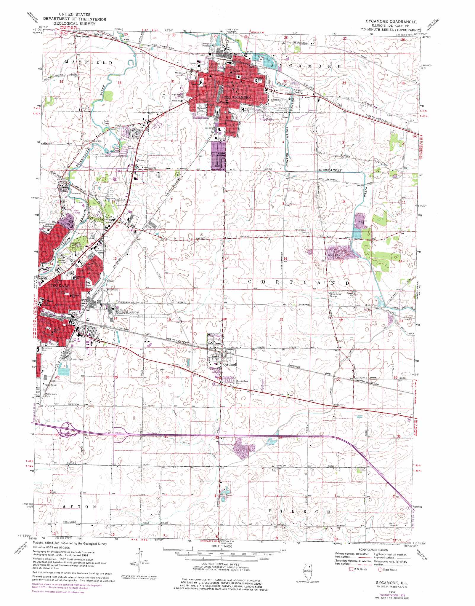
USGS Topo Quad 41088h6 - 1:24,000 scale
| Topo Map Name: | Sycamore |
| USGS Topo Quad ID: | 41088h6 |
| Print Size: | ca. 21 1/4" wide x 27" high |
| Southeast Coordinates: | 41.875° N latitude / 88.625° W longitude |
| Map Center Coordinates: | 41.9375° N latitude / 88.6875° W longitude |
| U.S. State: | IL |
| Filename: | o41088h6.jpg |
| Download Map JPG Image: | Sycamore topo map 1:24,000 scale |
| Map Type: | Topographic |
| Topo Series: | 7.5´ |
| Map Scale: | 1:24,000 |
| Source of Map Images: | United States Geological Survey (USGS) |
| Alternate Map Versions: |
Sycamore IL 1968, updated 1970 Download PDF Buy paper map Sycamore IL 1968, updated 1977 Download PDF Buy paper map Sycamore IL 2012 Download PDF Buy paper map Sycamore IL 2015 Download PDF Buy paper map |
1:24,000 Topo Quads surrounding Sycamore
Cherry Valley |
Belvidere South |
Riley |
Marengo South |
Huntley |
Fairdale |
Kirkland |
Genoa |
Hampshire |
Pingree Grove |
Creston |
De Kalb |
Sycamore |
Maple Park |
Elburn |
Lee |
Waterman |
Hinckley |
Big Rock |
Sugar Grove |
Paw Paw |
Shabbona Grove |
Somonauk |
Plano |
Yorkville |
> Back to 41088e1 at 1:100,000 scale
> Back to 41088a1 at 1:250,000 scale
> Back to U.S. Topo Maps home
Sycamore topo map: Gazetteer
Sycamore: Airports
DeKalb Taylor Municipal Airport elevation 278m 912′Kishwaukee Comm Health Heliport elevation 264m 866′
Ruder Airport elevation 260m 853′
Sycamore: Canals
Union Ditch Number 1 elevation 259m 849′Sycamore: Mines
Sears Quarry elevation 245m 803′Sycamore: Parks
Community Park elevation 257m 843′Hopkins Park elevation 262m 859′
Liberty Park elevation 265m 869′
McCormack Park elevation 271m 889′
P A Nehring Forest Preserve elevation 256m 839′
Sycamore Historic District elevation 265m 869′
Sycamore Swimming Pool elevation 253m 830′
Sycamore: Populated Places
Cortland elevation 275m 902′Edgebrook Mobile Home Park elevation 255m 836′
Evergreen Village Mobile Home Park elevation 253m 830′
Sycamore elevation 266m 872′
Sycamore: Post Offices
Sycamore Post Office elevation 266m 872′Sycamore digital topo map on disk
Buy this Sycamore topo map showing relief, roads, GPS coordinates and other geographical features, as a high-resolution digital map file on DVD:
Northern Illinois, Northern Indiana & Southwestern Michigan
Buy digital topo maps: Northern Illinois, Northern Indiana & Southwestern Michigan