Pine Bluffs Topo Map Wyoming
To zoom in, hover over the map of Pine Bluffs
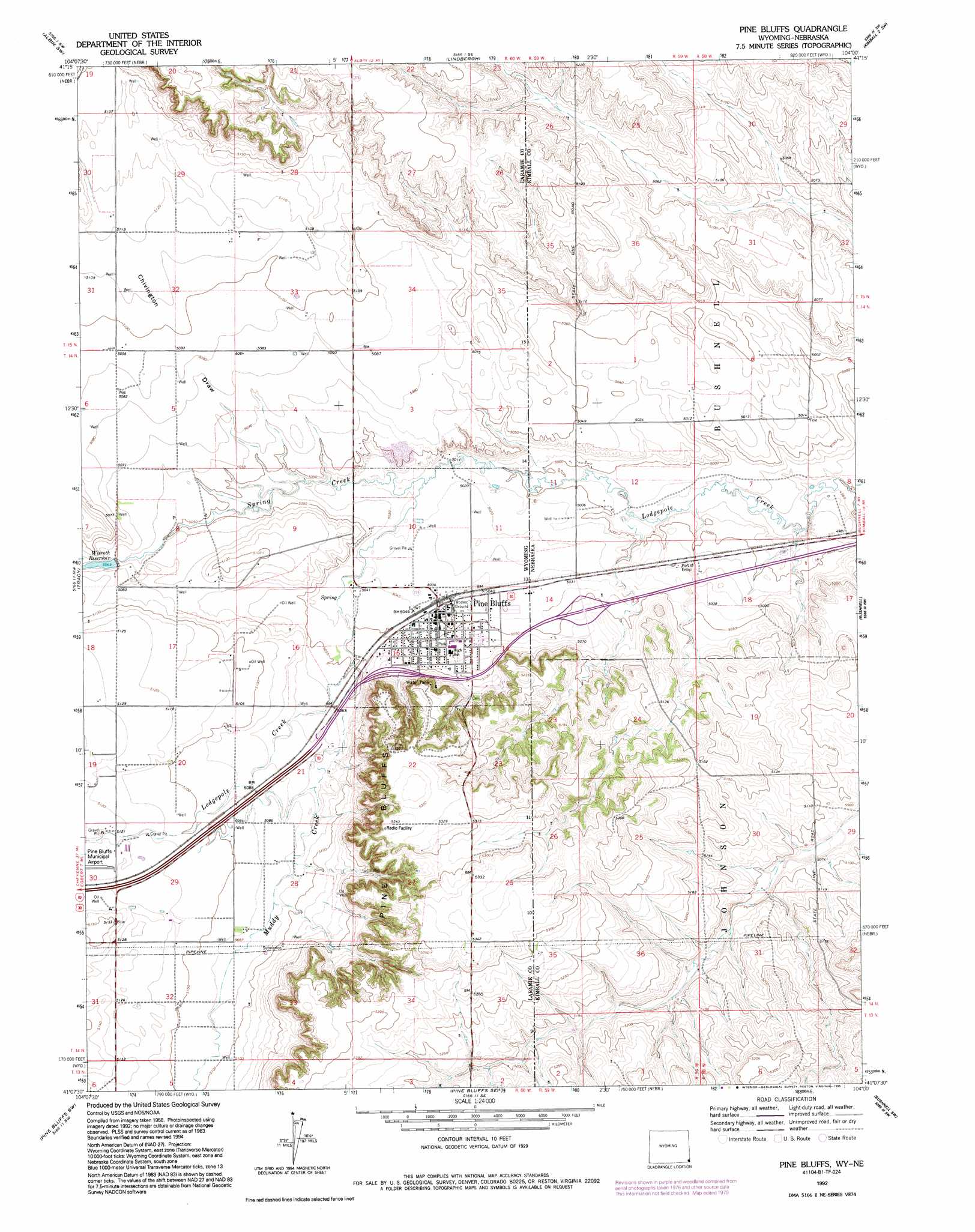
USGS Topo Quad 41104b1 - 1:24,000 scale
| Topo Map Name: | Pine Bluffs |
| USGS Topo Quad ID: | 41104b1 |
| Print Size: | ca. 21 1/4" wide x 27" high |
| Southeast Coordinates: | 41.125° N latitude / 104° W longitude |
| Map Center Coordinates: | 41.1875° N latitude / 104.0625° W longitude |
| U.S. States: | WY, NE |
| Filename: | o41104b1.jpg |
| Download Map JPG Image: | Pine Bluffs topo map 1:24,000 scale |
| Map Type: | Topographic |
| Topo Series: | 7.5´ |
| Map Scale: | 1:24,000 |
| Source of Map Images: | United States Geological Survey (USGS) |
| Alternate Map Versions: |
Pine Bluffs WY 1963, updated 1967 Download PDF Buy paper map Pine Bluffs WY 1963, updated 1979 Download PDF Buy paper map Pine Bluffs WY 1963, updated 1984 Download PDF Buy paper map Pine Bluffs WY 1968, updated 1978 Download PDF Buy paper map Pine Bluffs WY 1992, updated 1995 Download PDF Buy paper map Pine Bluffs WY 2012 Download PDF Buy paper map Pine Bluffs WY 2015 Download PDF Buy paper map |
1:24,000 Topo Quads surrounding Pine Bluffs
Round Top |
Gurney Peak |
Albin |
Kimball 2 Nw |
Kimball 2 Ne |
Midway Se |
Albin Sw |
Lindbergh |
Kimball 2 Sw |
Kimball 2 Se |
Burns |
Tracy |
Pine Bluffs |
Bushnell |
Oliver Reservoir |
Carpenter |
Pine Bluffs Sw |
Pine Bluffs Se |
Bushnell Sw |
Bushnell Se |
Hereford |
Grover North |
Grover Ne |
Dolan Spring |
Vim School |
> Back to 41104a1 at 1:100,000 scale
> Back to 41104a1 at 1:250,000 scale
> Back to U.S. Topo Maps home
Pine Bluffs topo map: Gazetteer
Pine Bluffs: Crossings
Interchange 1 elevation 1543m 5062′Pine Bluffs: Populated Places
Pine Bluffs elevation 1539m 5049′Pine Bluffs: Reservoirs
Wisroth Reservoir elevation 1544m 5065′Pine Bluffs: Streams
Muddy Creek elevation 1540m 5052′Spring Creek elevation 1530m 5019′
Pine Bluffs: Valleys
Chivington Draw elevation 1540m 5052′Pine Bluffs digital topo map on disk
Buy this Pine Bluffs topo map showing relief, roads, GPS coordinates and other geographical features, as a high-resolution digital map file on DVD:
Eastern Wyoming & Western South Dakota
Buy digital topo maps: Eastern Wyoming & Western South Dakota