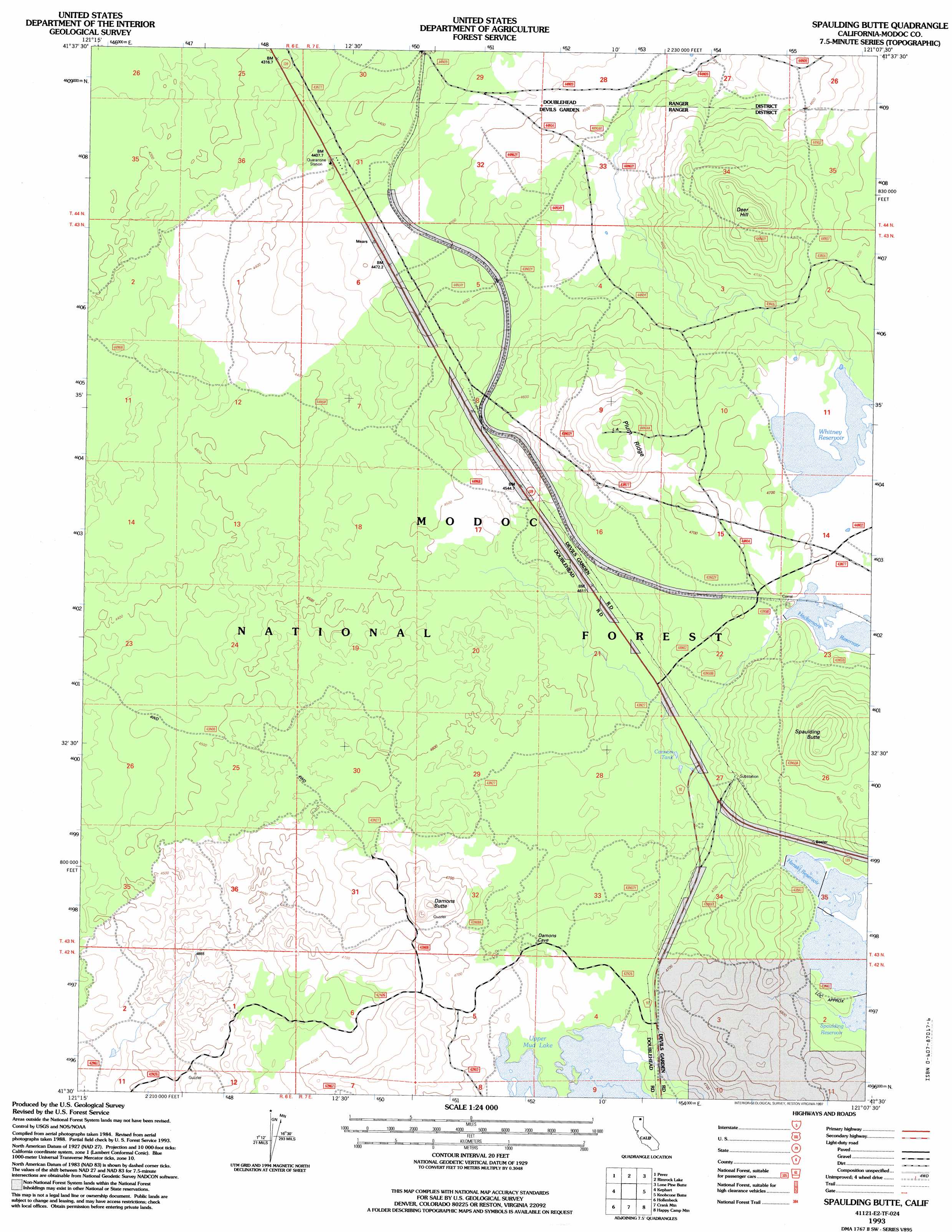
Spaulding Butte Topo Map California
To zoom in, hover over the map of Spaulding Butte
USGS Topo Quad 41121e2 - 1:24,000 scale
| Topo Map Name: | Spaulding Butte |
| USGS Topo Quad ID: | 41121e2 |
| Print Size: | ca. 21 1/4" wide x 27" high |
| Southeast Coordinates: | 41.5° N latitude / 121.125° W longitude |
| Map Center Coordinates: | 41.5625° N latitude / 121.1875° W longitude |
| U.S. State: | CA |
| Filename: | o41121e2.jpg |
| Download Map JPG Image: | Spaulding Butte topo map 1:24,000 scale |
| Map Type: | Topographic |
| Topo Series: | 7.5´ |
| Map Scale: | 1:24,000 |
| Source of Map Images: | United States Geological Survey (USGS) |
| Alternate Map Versions: |
Spaulding Butte CA 1988, updated 1988 Download PDF Buy paper map Spaulding Butte CA 1993, updated 1997 Download PDF Buy paper map Spaulding Butte CA 2012 Download PDF Buy paper map Spaulding Butte CA 2015 Download PDF Buy paper map |
| FStopo: | US Forest Service topo Spaulding Butte is available: Download FStopo PDF Download FStopo TIF |
1:24,000 Topo Quads surrounding Spaulding Butte
The Panhandle |
Copic |
Double Head Mountain |
Pinnacle Lake |
Pothole Valley |
Caldwell Butte |
Perez |
Rimrock Lake |
Lone Pine Butte |
Boles Meadows West |
West Of Kephart |
Kephart |
Spaulding Butte |
Knobcone Butte |
Ambrose |
Border Mountain |
Hollenbeck |
Crank Mountain |
Happy Camp Mountain |
Washington Mountain |
Whitehorse |
Egg Lake |
Donica Mountain |
Halls Canyon |
Adin Pass |
> Back to 41121e1 at 1:100,000 scale
> Back to 41120a1 at 1:250,000 scale
> Back to U.S. Topo Maps home
Spaulding Butte topo map: Gazetteer
Spaulding Butte: Dams
Hackamore Reservoir Dam elevation 1431m 4694′Spaulding 3 Dam elevation 1449m 4753′
Spaulding Butte: Lakes
Upper Mud Lake elevation 1421m 4662′Spaulding Butte: Populated Places
Meares elevation 1348m 4422′Spaulding Butte: Reservoirs
Cannon Tank elevation 1415m 4642′Hackamore Reservoir elevation 1431m 4694′
Henski Reservoir elevation 1449m 4753′
Spaulding 3 Reservoir elevation 1449m 4753′
Spaulding Reservoir elevation 1452m 4763′
Whitney Reservoir elevation 1431m 4694′
Spaulding Butte: Ridges
Plum Ridge elevation 1459m 4786′Spaulding Butte: Summits
Damons Butte elevation 1449m 4753′Deer Hill elevation 1475m 4839′
Spaulding Butte elevation 1504m 4934′
Spaulding Butte digital topo map on disk
Buy this Spaulding Butte topo map showing relief, roads, GPS coordinates and other geographical features, as a high-resolution digital map file on DVD: