Ipswich Topo Map Massachusetts
To zoom in, hover over the map of Ipswich
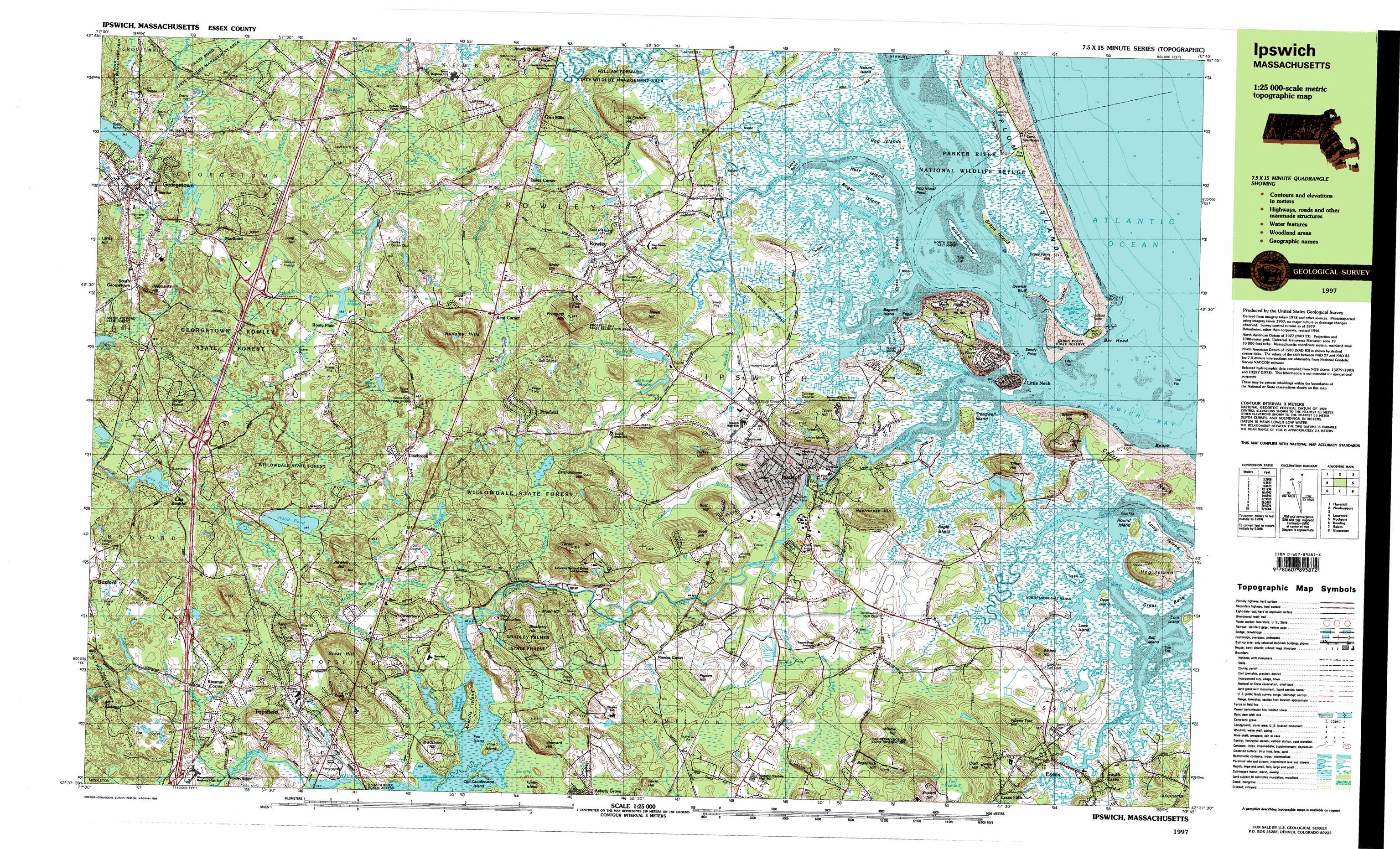
USGS Topo Quad 42070f7 - 1:25,000 scale
| Topo Map Name: | Ipswich |
| USGS Topo Quad ID: | 42070f7 |
| Print Size: | ca. 39" wide x 24" high |
| Southeast Coordinates: | 42.625° N latitude / 70.75° W longitude |
| Map Center Coordinates: | 42.6875° N latitude / 70.875° W longitude |
| U.S. State: | MA |
| Filename: | k42070f7.jpg |
| Download Map JPG Image: | Ipswich topo map 1:25,000 scale |
| Map Type: | Topographic |
| Topo Series: | 7.5´x15´ |
| Map Scale: | 1:25,000 |
| Source of Map Images: | United States Geological Survey (USGS) |
| Alternate Map Versions: |
Ipswich MA 1985, updated 1986 Download PDF Buy paper map Ipswich MA 1985, updated 1986 Download PDF Buy paper map Ipswich MA 1985, updated 1986 Download PDF Buy paper map Ipswich MA 1997, updated 1999 Download PDF Buy paper map |
1:24,000 Topo Quads surrounding Ipswich
Kingston |
Hampton |
Isles of Shoals |
||
Haverhill |
Newburyport East |
|||
South Groveland |
Ipswich |
Rockport |
||
Reading |
Salem |
Gloucester |
||
Boston North |
Marblehead South |
> Back to 42070e1 at 1:100,000 scale
> Back to 42070a1 at 1:250,000 scale
> Back to U.S. Topo Maps home
Ipswich topo map: Gazetteer
Ipswich: Airports
Bentley Heliport elevation 20m 65′Rider Heliport elevation 17m 55′
Snow Airport elevation 19m 62′
Ipswich: Bars
Emersons Rocks elevation 0m 0′Ipswich: Bays
Plum Island Sound elevation 0m 0′Ipswich: Beaches
Crane Beach elevation 3m 9′Ipswich: Bridges
Choate Bridge elevation -1m -4′Essex River Causeway elevation 0m 0′
Rowley Bridge elevation 12m 39′
Ipswich: Capes
Castle Neck elevation 3m 9′Hog Island Point elevation 2m 6′
Ipswich Bluff elevation 0m 0′
Laws Point elevation 2m 6′
Sandy Point elevation 0m 0′
Ipswich: Channels
Lords Creek elevation 0m 0′Stacy Creek elevation 0m 0′
Third Creek elevation 0m 0′
Ipswich: Cliffs
Bar Head elevation 8m 26′Eagle Hill elevation 0m 0′
Great Neck elevation 27m 88′
Ipswich: Dams
Baldpate Pond Dam elevation 32m 104′Bull Brook Reservoir Dam elevation 8m 26′
Dow Brook Reservoir Dam elevation 10m 32′
Fish Brook Dam elevation 25m 82′
Fourmile Pond Dam elevation 38m 124′
Hood Pond Dam elevation 15m 49′
Howes Pond Dam elevation 23m 75′
Ipswich Mills Dam elevation 4m 13′
Ipswich River Dam elevation 9m 29′
Lowe Pond Outlet Dam elevation 30m 98′
Lower Millpond Dam elevation 13m 42′
Mile Brook Dam elevation 16m 52′
Pentucket Pond Outlet Dam elevation 23m 75′
Rantoul Pond Dam elevation 2m 6′
Upper Millpond Dam elevation 15m 49′
Ipswich: Forests
Georgetown Rowley State Forest elevation 31m 101′Willowdale State Forest elevation 26m 85′
Ipswich: Islands
Averills Island elevation 14m 45′Bagwell Island elevation 2m 6′
Bass Rock elevation 0m 0′
Bull Island elevation 0m 0′
Choate Island elevation 49m 160′
Corn Island elevation 4m 13′
Cross Banks elevation 0m 0′
Cross Farm Hill elevation 10m 32′
Dean Island elevation 2m 6′
Eagle Island elevation 9m 29′
Grape Island elevation 0m 0′
Great Bank elevation 2m 6′
Hog Islands elevation 2m 6′
Holy Island elevation 2m 6′
Long Island elevation 4m 13′
Lowe Island elevation 3m 9′
Middle Ground elevation 2m 6′
Nelson Island elevation 3m 9′
Pine Island elevation 17m 55′
Roger Island elevation 1m 3′
Turkey Island elevation 24m 78′
Ipswich: Isthmuses
Little Neck elevation 17m 55′Ipswich: Lakes
Clark Pond elevation 2m 6′Pintail Pond elevation 11m 36′
Rockery Pond elevation 11m 36′
Stage Island Pool elevation 0m 0′
Stevens Pond elevation 40m 131′
Teal Pond elevation 10m 32′
Wilson Pond elevation 24m 78′
Ipswich: Parks
American League Park elevation 25m 82′B W Palmer State Park elevation 38m 124′
Bialek Park elevation 11m 36′
Boxford Village Historic District elevation 32m 104′
Ipswich Wildlife Sanctuary elevation 10m 32′
Parker River National Wildlife Refuge elevation 2m 6′
Plum Island State Park elevation 3m 9′
Ipswich: Populated Places
Aqawam (historical) elevation 8m 26′Boxford elevation 31m 101′
Camp Sea Haven elevation 4m 13′
Doles Corner elevation 16m 52′
East Boxford elevation 36m 118′
Essex elevation 7m 22′
Essex Falls elevation 9m 29′
Georgetown elevation 27m 88′
Glen Mills elevation 5m 16′
Hamilton elevation 15m 49′
Ipswich elevation 8m 26′
Kent Corner elevation 17m 55′
Kings Forest elevation 29m 95′
Kinsman Corner elevation 12m 39′
Leightons Corner elevation 22m 72′
Linebrook elevation 23m 75′
Little Neck elevation 17m 55′
Marlboro elevation 29m 95′
Nancys Corner elevation 16m 52′
Pinefield elevation 35m 114′
Rooty Plain elevation 20m 65′
Rowley elevation 14m 45′
South Byfield elevation 17m 55′
South Essex elevation 6m 19′
South Georgetown elevation 30m 98′
Topsfield elevation 18m 59′
Ipswich: Post Offices
Boxford Post Office (historical) elevation 28m 91′Essex Post Office elevation 10m 32′
Georgetown Post Office (historical) elevation 27m 88′
Ipswich Post Office elevation 5m 16′
Rowley Post Office (historical) elevation 16m 52′
South Essex Post Office (historical) elevation 6m 19′
Ipswich: Reservoirs
Baldpate Pond elevation 4m 13′Bull Brook Reservoir elevation 12m 39′
Dow Brook Reservoir elevation 11m 36′
Dow Brook Reservoir elevation 10m 32′
Fish Brook Reservoir elevation 25m 82′
Fourmile Pond elevation 0m 0′
Hood Pond elevation 15m 49′
Howes Pond elevation 23m 75′
Ipswich River Reservoir elevation 4m 13′
Ipswich River Reservoir elevation 9m 29′
Lowe Pond elevation 30m 98′
Lower Millpond elevation 17m 55′
Mile Brook Reservoir elevation 16m 52′
Pentucket Pond Outlet Reservoir elevation 23m 75′
Rantoul Pond elevation 2m 6′
Upper Millpond elevation 15m 49′
Ipswich: Streams
Alewife Brook elevation 2m 6′Bachelder Brook elevation 8m 26′
Black Brook elevation 5m 16′
Broad Creek elevation 0m 0′
Bull Brook elevation 4m 13′
Club Head Creek elevation 0m 0′
Dow Brook elevation 4m 13′
Eagle Hill River elevation 0m 0′
Ebben Creek elevation 1m 3′
Egypt River elevation 1m 3′
Fish Brook elevation 11m 36′
Fox Creek elevation 0m 0′
Grape Island Creek elevation 2m 6′
Gravelly Brook elevation 6m 19′
Great Swamp Brook elevation 9m 29′
Howlett Brook elevation 8m 26′
Idlewild Brook elevation 10m 32′
Ipswich River elevation 0m 0′
Jackman Brook elevation 5m 16′
Kimball Brook elevation 3m 9′
Labor in Vain Creek elevation 0m 0′
Laws Creek elevation 0m 0′
Long Causeway Brook elevation 6m 19′
Lufkin Creek elevation 1m 3′
Metcalf Creek elevation 1m 3′
Mile Brook elevation 10m 32′
Miles River elevation 7m 22′
Muddy Brook elevation 19m 62′
Muddy Run elevation 1m 3′
Neck Creek elevation 0m 0′
Nelson Island Creek elevation 0m 0′
Ox Pasture Brook elevation 1m 3′
Paine Creek elevation 0m 0′
Penn Brook elevation 24m 78′
Pine Creek elevation 2m 6′
Pye Brook elevation 26m 85′
Roger Island River elevation 0m 0′
Rowley River elevation 0m 0′
Shad Creek elevation 0m 0′
Six Goose Creek elevation 0m 0′
Soginese Creek elevation 1m 3′
Treadwell Island Creek elevation 0m 0′
West Creek elevation 1m 3′
Wheeler Brook elevation 3m 9′
Ipswich: Summits
Bare Hill elevation 54m 177′Bartholomew Hill elevation 53m 173′
Bear Hill elevation 48m 157′
Blueberry Hill elevation 64m 209′
Bradstreet Hill elevation 32m 104′
Bush Hill elevation 61m 200′
Castle Hill elevation 46m 150′
Choate Hill elevation 55m 180′
Craft Hill elevation 55m 180′
Eveleth Hill elevation 57m 187′
Fifteen Tree Hill elevation 40m 131′
Great Hill elevation 75m 246′
Heartbreak Hill elevation 50m 164′
Hunsley Hills elevation 48m 157′
Jewett Hill elevation 58m 190′
Little Turners Hill elevation 49m 160′
Long Hill elevation 64m 209′
Long Hill elevation 67m 219′
Moon Hill elevation 60m 196′
Mound Eleanor elevation 54m 177′
North Ridge elevation 34m 111′
Ornes Hill elevation 26m 85′
Ox Pasture Hill elevation 55m 180′
Pigeon Hill elevation 30m 98′
Plover Hill elevation 33m 108′
Prospect Hill elevation 77m 252′
Redshanks Hill elevation 49m 160′
Round Island elevation 5m 16′
Sagamore Hill elevation 55m 180′
Savin Hill elevation 27m 88′
Scott Hill elevation 52m 170′
Smith Hill elevation 48m 157′
Stage Island elevation 2m 6′
Steep Hill elevation 34m 111′
Tilton Hill elevation 41m 134′
Timber Hill elevation 45m 147′
Town Hill elevation 65m 213′
Town Hill elevation 2m 6′
Treadwell Island elevation 6m 19′
Turkey Hill elevation 74m 242′
Turner Hill elevation 70m 229′
Vineyard Hill elevation 52m 170′
Whites Hill elevation 30m 98′
Willow Hill elevation 43m 141′
Ipswich: Swamps
Bunker Meadows elevation 10m 32′Castle Neck River Marshes elevation 2m 6′
Eagle Hill River Marshes elevation 2m 6′
Fox Creek Marshes elevation 2m 6′
Hawk Meadow elevation 20m 65′
Ipswich River Marshes elevation 3m 9′
Nelson Island Marshes elevation 3m 9′
Roger Island River Marshes elevation 2m 6′
Sand Creek Marshes elevation 2m 6′
Turf Meadow elevation 27m 88′
West Creek Marshes elevation 2m 6′
Ipswich digital topo map on disk
Buy this Ipswich topo map showing relief, roads, GPS coordinates and other geographical features, as a high-resolution digital map file on DVD:
Maine, New Hampshire, Rhode Island & Eastern Massachusetts
Buy digital topo maps: Maine, New Hampshire, Rhode Island & Eastern Massachusetts