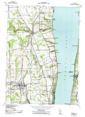
Dundee Topo Map New York
To zoom in, hover over the map of Dundee
USGS Topo Quad 42076e8 - 1:24,000 scale
| Topo Map Name: | Dundee |
| USGS Topo Quad ID: | 42076e8 |
| Print Size: | ca. 21 1/4" wide x 27" high |
| Southeast Coordinates: | 42.5° N latitude / 76.875° W longitude |
| Map Center Coordinates: | 42.5625° N latitude / 76.9375° W longitude |
| U.S. State: | NY |
| Filename: | o42076e8.jpg |
| Download Map JPG Image: | Dundee topo map 1:24,000 scale |
| Map Type: | Topographic |
| Topo Series: | 7.5´ |
| Map Scale: | 1:24,000 |
| Source of Map Images: | United States Geological Survey (USGS) |
| Alternate Map Versions: |
Dundee NY 1942, updated 1957 Download PDF Buy paper map Dundee NY 1942, updated 1964 Download PDF Buy paper map Dundee NY 1942, updated 1984 Download PDF Buy paper map Dundee NY 2010 Download PDF Buy paper map Dundee NY 2013 Download PDF Buy paper map Dundee NY 2016 Download PDF Buy paper map |
1:24,000 Topo Quads surrounding Dundee
> Back to 42076e1 at 1:100,000 scale
> Back to 42076a1 at 1:250,000 scale
> Back to U.S. Topo Maps home
Dundee topo map: Gazetteer
Dundee: Airports
Dundee Flying Club Airport elevation 313m 1026′Greenlawn Farm Airport elevation 304m 997′
Dundee: Capes
Baskin Point elevation 136m 446′Castle Point elevation 138m 452′
Keady Point elevation 137m 449′
Lodi Point elevation 137m 449′
Plum Point elevation 135m 442′
Ross Point elevation 137m 449′
Severne Point elevation 136m 446′
Squaw Point elevation 138m 452′
Starkey Point elevation 137m 449′
Valois Point elevation 141m 462′
Dundee: Parks
Dundee Village Historic District elevation 300m 984′Lodi Point State Marine Park elevation 137m 449′
Dundee: Populated Places
Dundee elevation 300m 984′Himrod elevation 243m 797′
Lakemont elevation 263m 862′
Lamoreaux Landing elevation 138m 452′
Oakwood Estates Mobile Home Park elevation 297m 974′
Randall Crossing elevation 230m 754′
Starkey elevation 245m 803′
Valois elevation 188m 616′
Dundee: Streams
Breakneck Creek elevation 136m 446′Curry Creek elevation 135m 442′
Indian Run elevation 136m 446′
Mill Creek elevation 136m 446′
Plum Point Creek elevation 136m 446′
Dundee: Summits
Sprout Hill elevation 428m 1404′Dundee: Valleys
Chub Hollow elevation 317m 1040′Dundee digital topo map on disk
Buy this Dundee topo map showing relief, roads, GPS coordinates and other geographical features, as a high-resolution digital map file on DVD:
New York, Vermont, Connecticut & Western Massachusetts
Buy digital topo maps: New York, Vermont, Connecticut & Western Massachusetts


