Glenn Topo Map Michigan
To zoom in, hover over the map of Glenn
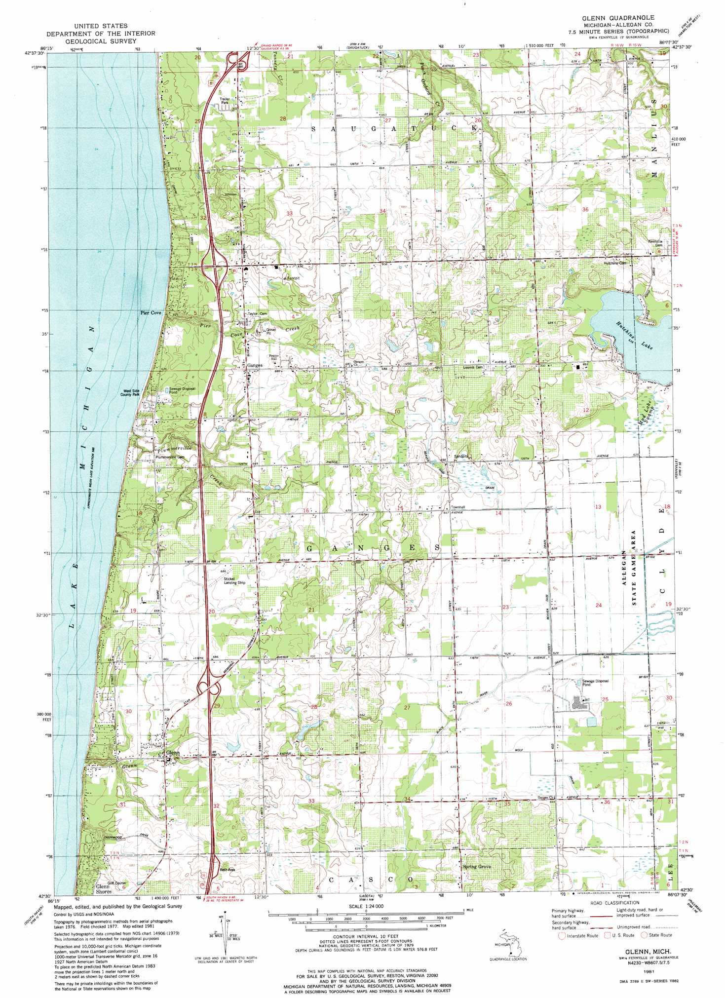
USGS Topo Quad 42086e2 - 1:24,000 scale
| Topo Map Name: | Glenn |
| USGS Topo Quad ID: | 42086e2 |
| Print Size: | ca. 21 1/4" wide x 27" high |
| Southeast Coordinates: | 42.5° N latitude / 86.125° W longitude |
| Map Center Coordinates: | 42.5625° N latitude / 86.1875° W longitude |
| U.S. State: | MI |
| Filename: | o42086e2.jpg |
| Download Map JPG Image: | Glenn topo map 1:24,000 scale |
| Map Type: | Topographic |
| Topo Series: | 7.5´ |
| Map Scale: | 1:24,000 |
| Source of Map Images: | United States Geological Survey (USGS) |
| Alternate Map Versions: |
Glenn MI 1981, updated 1982 Download PDF Buy paper map Glenn MI 2011 Download PDF Buy paper map Glenn MI 2014 Download PDF Buy paper map Glenn MI 2017 Download PDF Buy paper map |
1:24,000 Topo Quads surrounding Glenn
Holland West |
Holland East |
Hudsonville West |
||
Saugatuck |
Hamilton West |
Hamilton East |
||
Glenn |
Fennville |
Millgrove |
||
South Haven |
Lacota |
Pullman |
Bloomingdale |
|
Covert |
Mcdonald |
Bangor |
Gobles West |
> Back to 42086e1 at 1:100,000 scale
> Back to 42086a1 at 1:250,000 scale
> Back to U.S. Topo Maps home
Glenn topo map: Gazetteer
Glenn: Airports
Reading Airport elevation 205m 672′Stickel Landing Strip elevation 208m 682′
Glenn: Canals
Beaver Dam Drain elevation 195m 639′Black River Drain elevation 189m 620′
Wolf Drain elevation 194m 636′
Glenn: Crossings
Interchange 30 elevation 209m 685′Interchange 34 elevation 198m 649′
Interchange 36 elevation 203m 666′
Glenn: Lakes
Hutchins Lake elevation 194m 636′Glenn: Parks
Allegan County Park elevation 189m 620′Pier Cove Historical Marker elevation 183m 600′
West Side County Park elevation 190m 623′
Glenn: Populated Places
Ganges elevation 201m 659′Glenn elevation 199m 652′
Glenn Shores elevation 201m 659′
Grange Corners elevation 207m 679′
Pier Cove elevation 180m 590′
Shorecrest elevation 200m 656′
Spring Grove elevation 208m 682′
Glenn: Post Offices
Belknap Post Office (historical) elevation 213m 698′Esther Post Office (historical) elevation 192m 629′
Ganges Post Office (historical) elevation 201m 659′
Glenn Post Office elevation 198m 649′
Peachbelt Post Office (historical) elevation 207m 679′
Spring Grove Post Office (historical) elevation 209m 685′
Glenn: Streams
Glenn Creek elevation 191m 626′North State Road Drain elevation 189m 620′
Pier Cove Creek elevation 178m 583′
Plummerville Creek elevation 178m 583′
Glenn: Swamps
Mud Lake Swamp elevation 194m 636′Glenn digital topo map on disk
Buy this Glenn topo map showing relief, roads, GPS coordinates and other geographical features, as a high-resolution digital map file on DVD:
Northern Illinois, Northern Indiana & Southwestern Michigan
Buy digital topo maps: Northern Illinois, Northern Indiana & Southwestern Michigan