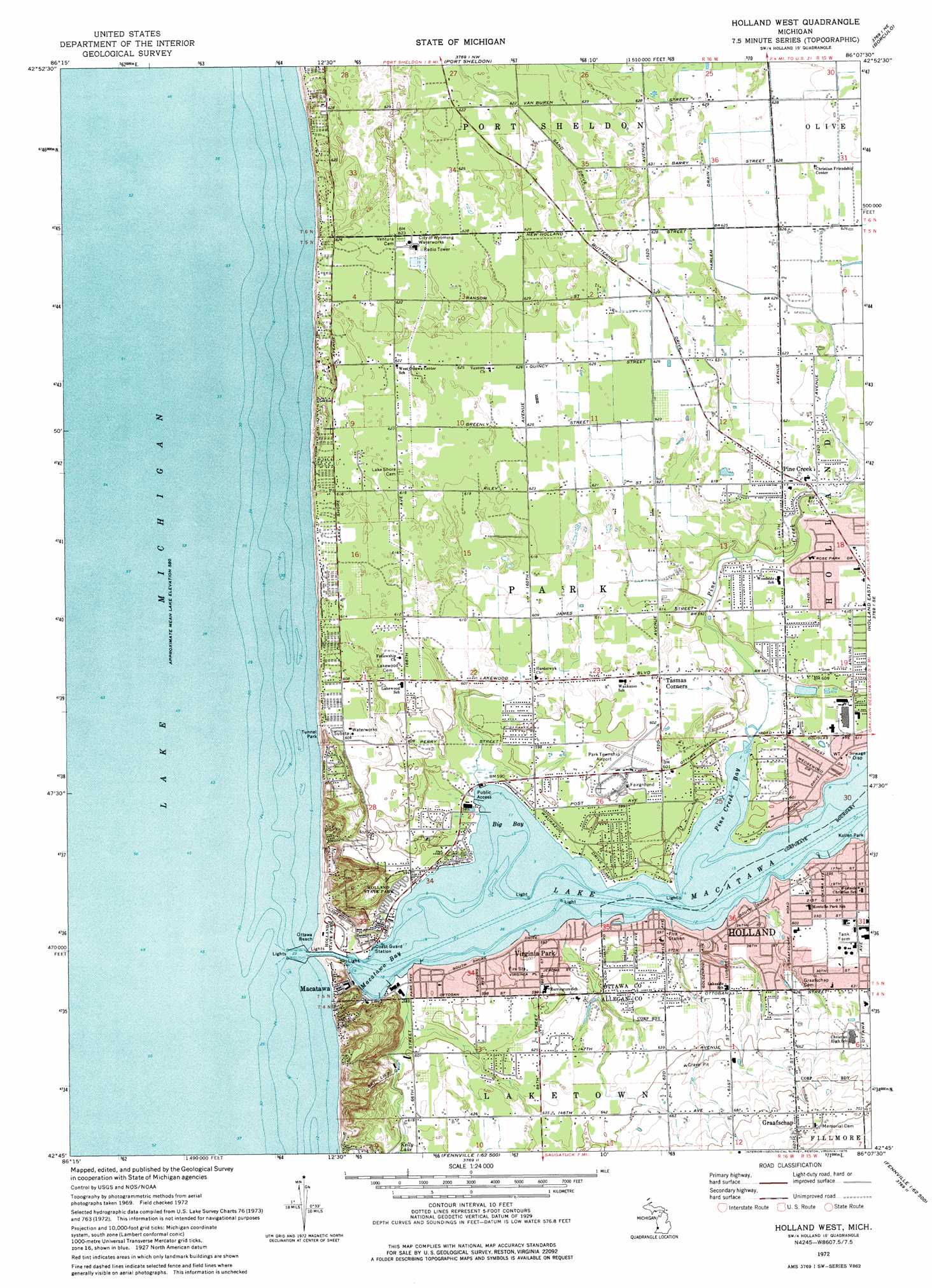
Holland West Topo Map Michigan
To zoom in, hover over the map of Holland West
USGS Topo Quad 42086g2 - 1:24,000 scale
| Topo Map Name: | Holland West |
| USGS Topo Quad ID: | 42086g2 |
| Print Size: | ca. 21 1/4" wide x 27" high |
| Southeast Coordinates: | 42.75° N latitude / 86.125° W longitude |
| Map Center Coordinates: | 42.8125° N latitude / 86.1875° W longitude |
| U.S. State: | MI |
| Filename: | o42086g2.jpg |
| Download Map JPG Image: | Holland West topo map 1:24,000 scale |
| Map Type: | Topographic |
| Topo Series: | 7.5´ |
| Map Scale: | 1:24,000 |
| Source of Map Images: | United States Geological Survey (USGS) |
| Alternate Map Versions: |
Holland West MI 1972, updated 1975 Download PDF Buy paper map Holland West MI 2011 Download PDF Buy paper map Holland West MI 2014 Download PDF Buy paper map Holland West MI 2017 Download PDF Buy paper map |
1:24,000 Topo Quads surrounding Holland West
Grand Haven |
Nunica |
Coopersville |
||
Port Sheldon |
Borculo |
Allendale |
||
Holland West |
Holland East |
Hudsonville West |
||
Saugatuck |
Hamilton West |
Hamilton East |
||
Glenn |
Fennville |
Millgrove |
> Back to 42086e1 at 1:100,000 scale
> Back to 42086a1 at 1:250,000 scale
> Back to U.S. Topo Maps home
Holland West topo map: Gazetteer
Holland West: Airports
Park Township Airport elevation 183m 600′Holland West: Bays
Big Bay elevation 177m 580′Macatawa Bay elevation 177m 580′
Pine Creek Bay elevation 177m 580′
Holland West: Beaches
Ottawa Beach elevation 179m 587′Rosabelle Beach elevation 183m 600′
Tunnel Park elevation 181m 593′
Holland West: Canals
Harlem Drain elevation 189m 620′Holland West: Capes
Superior Point elevation 179m 587′Holland West: Lakes
Lake Macatawa elevation 177m 580′Holland West: Parks
Central Park elevation 178m 583′Central Park Chapel Historical Marker elevation 181m 593′
DeGraaf Nature Center elevation 180m 590′
Graafschap Christian Reformed Church Historical Marker elevation 218m 715′
Holland Harbor Historical Marker elevation 178m 583′
Holland Harbor Lighthouse Historical Marker elevation 178m 583′
Holland State Park elevation 189m 620′
Jenison Park elevation 180m 590′
Lakeview Park elevation 182m 597′
Macatawa Park elevation 181m 593′
Marigold Lodge Historical Marker elevation 180m 590′
Ottawa Beach Historical Marker elevation 179m 587′
Quincy Park elevation 190m 623′
Riley Park elevation 188m 616′
Waukazoo Woods Historical Marker elevation 180m 590′
Wendt Park elevation 187m 613′
Winstrom Park elevation 179m 587′
Wolters Woods Park elevation 192m 629′
Holland West: Populated Places
Beechwood elevation 185m 606′Graafschap elevation 218m 715′
Holiday West Village Mobile Home Park elevation 192m 629′
Macatawa elevation 180m 590′
Pine Creek elevation 189m 620′
Tasmas Corners elevation 186m 610′
Virginia Park elevation 183m 600′
Holland West: Post Offices
Graafschap Post Office (historical) elevation 218m 715′Macatawa Post Office (historical) elevation 180m 590′
Ottawa Beach Post Office (historical) elevation 182m 597′
Ventura Post Office (historical) elevation 194m 636′
Holland West: Streams
Pine Creek elevation 178m 583′Holland West digital topo map on disk
Buy this Holland West topo map showing relief, roads, GPS coordinates and other geographical features, as a high-resolution digital map file on DVD:
Northern Illinois, Northern Indiana & Southwestern Michigan
Buy digital topo maps: Northern Illinois, Northern Indiana & Southwestern Michigan