Dows West Topo Map Iowa
To zoom in, hover over the map of Dows West
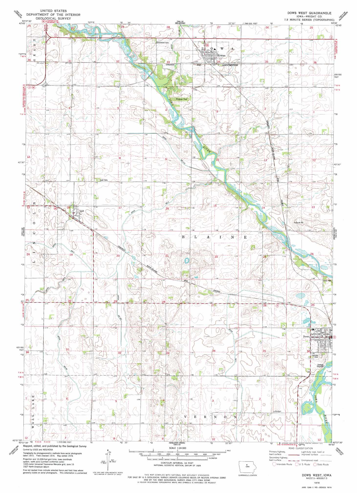
USGS Topo Quad 42093f5 - 1:24,000 scale
| Topo Map Name: | Dows West |
| USGS Topo Quad ID: | 42093f5 |
| Print Size: | ca. 21 1/4" wide x 27" high |
| Southeast Coordinates: | 42.625° N latitude / 93.5° W longitude |
| Map Center Coordinates: | 42.6875° N latitude / 93.5625° W longitude |
| U.S. State: | IA |
| Filename: | o42093f5.jpg |
| Download Map JPG Image: | Dows West topo map 1:24,000 scale |
| Map Type: | Topographic |
| Topo Series: | 7.5´ |
| Map Scale: | 1:24,000 |
| Source of Map Images: | United States Geological Survey (USGS) |
| Alternate Map Versions: |
Dows West IA 1978, updated 1979 Download PDF Buy paper map Dows West IA 2010 Download PDF Buy paper map Dows West IA 2013 Download PDF Buy paper map Dows West IA 2015 Download PDF Buy paper map |
1:24,000 Topo Quads surrounding Dows West
Kanawha |
Olaf |
Goodell |
Thornton |
Swaledale |
Kanawha Se |
Cornelia |
Belmond |
Alexander |
Latimer |
Holmes |
Clarion |
Dows West |
Dows East |
Coulter |
Woolstock |
Clarion Sw |
Sheldon Creek |
Popejoy |
Iowa Falls West |
Webster City |
Blairsburg |
Williams |
Buckeye West |
Buckeye East |
> Back to 42093e1 at 1:100,000 scale
> Back to 42092a1 at 1:250,000 scale
> Back to U.S. Topo Maps home
Dows West topo map: Gazetteer
Dows West: Canals
Ditch Number 187 elevation 357m 1171′Ditch Number 213 elevation 351m 1151′
Ditch Number 55 elevation 368m 1207′
Ditch Number 7 elevation 351m 1151′
Dows West: Parks
Bingham Park elevation 358m 1174′Dows Park elevation 357m 1171′
Groom Area elevation 350m 1148′
Gun Club Corner elevation 356m 1167′
Horse Grove - Rietz Forest Area elevation 351m 1151′
Prairie Smoke Wildlife Area - Central Unit elevation 372m 1220′
Prairie Smoke Wildlife Area - East Unit elevation 375m 1230′
Dows West: Populated Places
Dows elevation 351m 1151′Galt elevation 367m 1204′
Rowan elevation 369m 1210′
Dows West: Post Offices
Dows Post Office elevation 351m 1151′Fryeburgh Post Office (historical) elevation 366m 1200′
Galt Post Office elevation 367m 1204′
Otisville Post Office (historical) elevation 351m 1151′
Otisville Post Office (historical) elevation 359m 1177′
Rowan Post Office elevation 369m 1210′
Dows West digital topo map on disk
Buy this Dows West topo map showing relief, roads, GPS coordinates and other geographical features, as a high-resolution digital map file on DVD: