Flat Top Mountain Topo Map Oregon
To zoom in, hover over the map of Flat Top Mountain
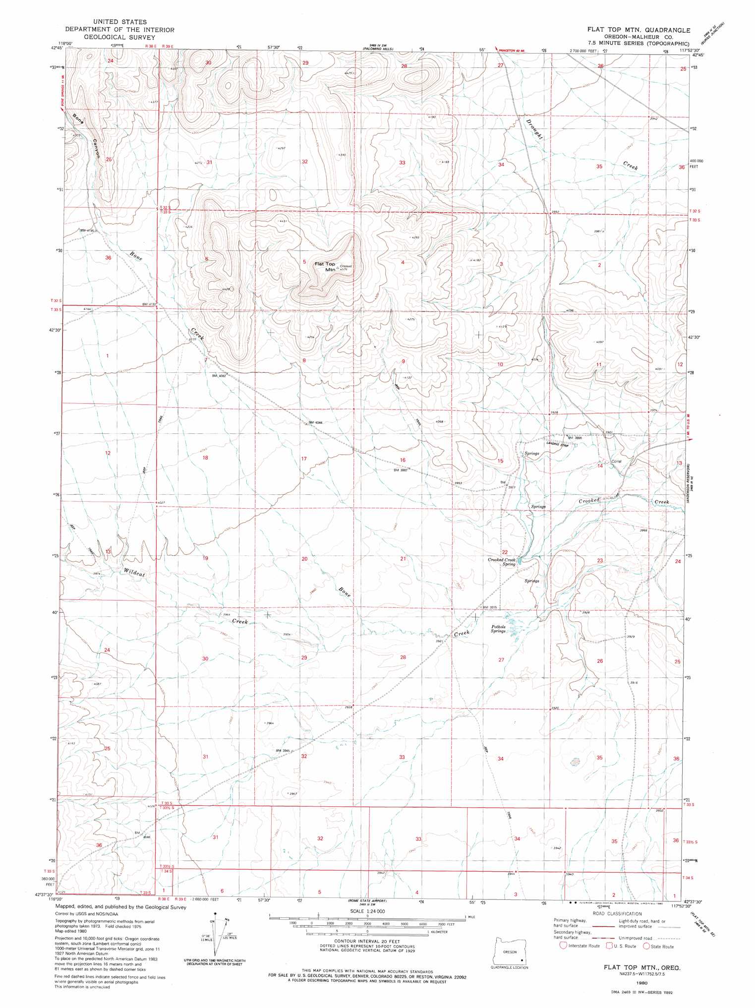
USGS Topo Quad 42117f8 - 1:24,000 scale
| Topo Map Name: | Flat Top Mountain |
| USGS Topo Quad ID: | 42117f8 |
| Print Size: | ca. 21 1/4" wide x 27" high |
| Southeast Coordinates: | 42.625° N latitude / 117.875° W longitude |
| Map Center Coordinates: | 42.6875° N latitude / 117.9375° W longitude |
| U.S. State: | OR |
| Filename: | o42117f8.jpg |
| Download Map JPG Image: | Flat Top Mountain topo map 1:24,000 scale |
| Map Type: | Topographic |
| Topo Series: | 7.5´ |
| Map Scale: | 1:24,000 |
| Source of Map Images: | United States Geological Survey (USGS) |
| Alternate Map Versions: |
Flat Top Mtn OR 1980, updated 1980 Download PDF Buy paper map Flat Top Mountain OR 2011 Download PDF Buy paper map Flat Top Mountain OR 2014 Download PDF Buy paper map |
1:24,000 Topo Quads surrounding Flat Top Mountain
Ryegrass Butte |
Johnny Creek Spring |
Palomino Lake |
Iron Mountain |
Owyhee Butte |
Johnny Creek Sw |
Groan Canyon |
Palomino Hills |
Burns Junction |
Rome |
Ancient Lake Well |
Grassy Ridge Well |
Flat Top Mountain |
Anderson Reservoir |
The Basin |
Coyote Lake West |
Coyote Lake East |
Rome State Airport |
Flat Top Mountain Se |
Bowden Ranch |
Coyote Meadows |
Twelvemile Ridge |
Three Man Butte Well |
Basque |
Battle Creek Ranch |
> Back to 42117e1 at 1:100,000 scale
> Back to 42116a1 at 1:250,000 scale
> Back to U.S. Topo Maps home
Flat Top Mountain topo map: Gazetteer
Flat Top Mountain: Canals
Kanehinke Ditch elevation 1183m 3881′Tudor Ditch elevation 1196m 3923′
Flat Top Mountain: Springs
Crooked Creek Spring elevation 1194m 3917′Pothole Springs elevation 1193m 3914′
Flat Top Mountain: Streams
Bone Creek elevation 1179m 3868′Wildcat Creek elevation 1199m 3933′
Flat Top Mountain: Summits
Flat Top Mountain elevation 1392m 4566′Flat Top Mountain: Valleys
Bone Canyon elevation 1278m 4192′Flat Top Mountain digital topo map on disk
Buy this Flat Top Mountain topo map showing relief, roads, GPS coordinates and other geographical features, as a high-resolution digital map file on DVD: