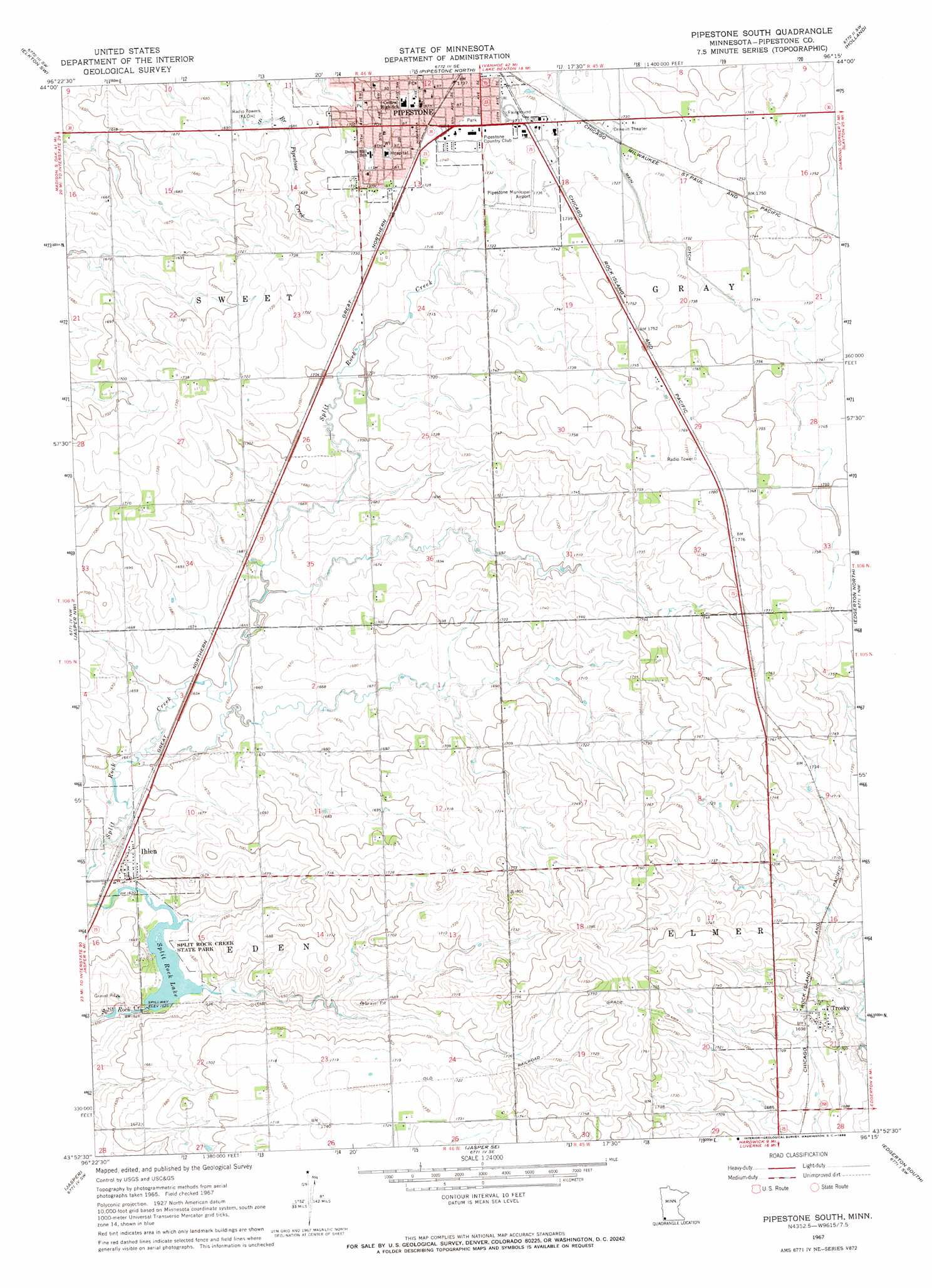
Pipestone South Topo Map Minnesota
To zoom in, hover over the map of Pipestone South
USGS Topo Quad 43096h3 - 1:24,000 scale
| Topo Map Name: | Pipestone South |
| USGS Topo Quad ID: | 43096h3 |
| Print Size: | ca. 21 1/4" wide x 27" high |
| Southeast Coordinates: | 43.875° N latitude / 96.25° W longitude |
| Map Center Coordinates: | 43.9375° N latitude / 96.3125° W longitude |
| U.S. State: | MN |
| Filename: | o43096h3.jpg |
| Download Map JPG Image: | Pipestone South topo map 1:24,000 scale |
| Map Type: | Topographic |
| Topo Series: | 7.5´ |
| Map Scale: | 1:24,000 |
| Source of Map Images: | United States Geological Survey (USGS) |
| Alternate Map Versions: |
Pipestone South MN 1967, updated 1968 Download PDF Buy paper map Pipestone South MN 2010 Download PDF Buy paper map Pipestone South MN 2013 Download PDF Buy paper map Pipestone South MN 2016 Download PDF Buy paper map |
1:24,000 Topo Quads surrounding Pipestone South
Flandreau Ne |
Elkton |
Verdi |
Ruthton Nw |
Ruthton |
Flandreau |
Elkton Sw |
Pipestone North |
Holland |
Woodstock |
Dell Rapids Ne |
Jasper Nw |
Pipestone South |
Edgerton North |
Edgerton Ne |
Dell Rapids Se |
Jasper |
Jasper Se |
Edgerton South |
Kenneth |
Garretson West |
Garretson East |
Hills Ne |
Luverne |
Magnolia |
> Back to 43096e1 at 1:100,000 scale
> Back to 43096a1 at 1:250,000 scale
> Back to U.S. Topo Maps home
Pipestone South topo map: Gazetteer
Pipestone South: Airports
Dykstra Acreage Airport elevation 516m 1692′Pipestone Municipal Airport elevation 527m 1729′
Pipestone South: Bridges
Split Rock Bridge elevation 490m 1607′Pipestone South: Canals
Main Ditch elevation 521m 1709′Pipestone South: Dams
Splitrock Lake Dam elevation 494m 1620′Pipestone South: Parks
Civil War Monument elevation 528m 1732′Erickson Park elevation 529m 1735′
Harmon Park elevation 529m 1735′
Paulsen Athletic Field elevation 515m 1689′
Southwest Playfield elevation 517m 1696′
Split Rock Creek State Park elevation 495m 1624′
Pipestone South: Populated Places
Ihlen elevation 502m 1646′Trosky elevation 519m 1702′
Pipestone South: Post Offices
Ihlen Post Office elevation 502m 1646′Pipestone Post Office elevation 525m 1722′
Trosky Post Office elevation 519m 1702′
Pipestone South: Reservoirs
Split Rock Lake elevation 495m 1624′Splitrock Lake elevation 494m 1620′
Pipestone South digital topo map on disk
Buy this Pipestone South topo map showing relief, roads, GPS coordinates and other geographical features, as a high-resolution digital map file on DVD:
Eastern North Dakota & Eastern South Dakota
Buy digital topo maps: Eastern North Dakota & Eastern South Dakota