Threemile Butte Topo Map Wyoming
To zoom in, hover over the map of Threemile Butte
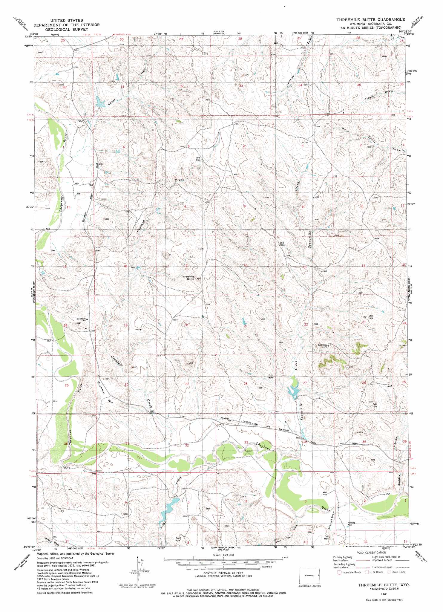
USGS Topo Quad 43104d4 - 1:24,000 scale
| Topo Map Name: | Threemile Butte |
| USGS Topo Quad ID: | 43104d4 |
| Print Size: | ca. 21 1/4" wide x 27" high |
| Southeast Coordinates: | 43.375° N latitude / 104.375° W longitude |
| Map Center Coordinates: | 43.4375° N latitude / 104.4375° W longitude |
| U.S. State: | WY |
| Filename: | o43104d4.jpg |
| Download Map JPG Image: | Threemile Butte topo map 1:24,000 scale |
| Map Type: | Topographic |
| Topo Series: | 7.5´ |
| Map Scale: | 1:24,000 |
| Source of Map Images: | United States Geological Survey (USGS) |
| Alternate Map Versions: |
Threemile Butte WY 1981, updated 1981 Download PDF Buy paper map Threemile Butte WY 2012 Download PDF Buy paper map Threemile Butte WY 2015 Download PDF Buy paper map |
| FStopo: | US Forest Service topo Threemile Butte is available: Download FStopo PDF Download FStopo TIF |
1:24,000 Topo Quads surrounding Threemile Butte
Clareton |
Dupont Creek |
Timber Creek |
Morrisey Ne |
Owens |
The Nose West |
The Nose East |
Morrisey |
Morrisey Se |
Dewey Sw |
Garland Draw |
Horseshoe Bend |
Threemile Butte |
Little Alkali Creek |
Riverview |
Dixon Ranch |
Boggy Reservoir |
Greasewood Creek |
Bowen Flat |
Mule Creek |
Lance Creek Nw |
Funny Rock |
Buck Creek Hills |
Redbird |
Oat Creek Nw |
> Back to 43104a1 at 1:100,000 scale
> Back to 43104a1 at 1:250,000 scale
> Back to U.S. Topo Maps home
Threemile Butte topo map: Gazetteer
Threemile Butte: Dams
Hanson Dam elevation 1185m 3887′Hanson Dam elevation 1202m 3943′
Mrs W E White Dam elevation 1177m 3861′
New Deal Number 1 Dam elevation 1164m 3818′
Seven Mile Number 1 Dam elevation 1176m 3858′
Threemile Butte: Reservoirs
Hanson Number 2 Reservoir elevation 1202m 3943′Hanson Reservoir elevation 1185m 3887′
Mrs W E White Reservoir elevation 1177m 3861′
New Deal Number 1 Reservoir elevation 1164m 3818′
Seven Mile Number 1 Reservoir elevation 1176m 3858′
Threemile Butte: Streams
Boggy Creek elevation 1153m 3782′Count Creek elevation 1177m 3861′
Crooked Creek elevation 1153m 3782′
Sevenmile Creek elevation 1152m 3779′
Threemile Butte: Summits
Sheldon Hill elevation 1209m 3966′Threemile Butte elevation 1285m 4215′
Threemile Butte: Valleys
Charlies Draw elevation 1146m 3759′Dutch Joe Draw elevation 1147m 3763′
Hungry Hollow elevation 1145m 3756′
Threemile Butte digital topo map on disk
Buy this Threemile Butte topo map showing relief, roads, GPS coordinates and other geographical features, as a high-resolution digital map file on DVD:
Eastern Wyoming & Western South Dakota
Buy digital topo maps: Eastern Wyoming & Western South Dakota