Castle Gardens Topo Map Wyoming
To zoom in, hover over the map of Castle Gardens
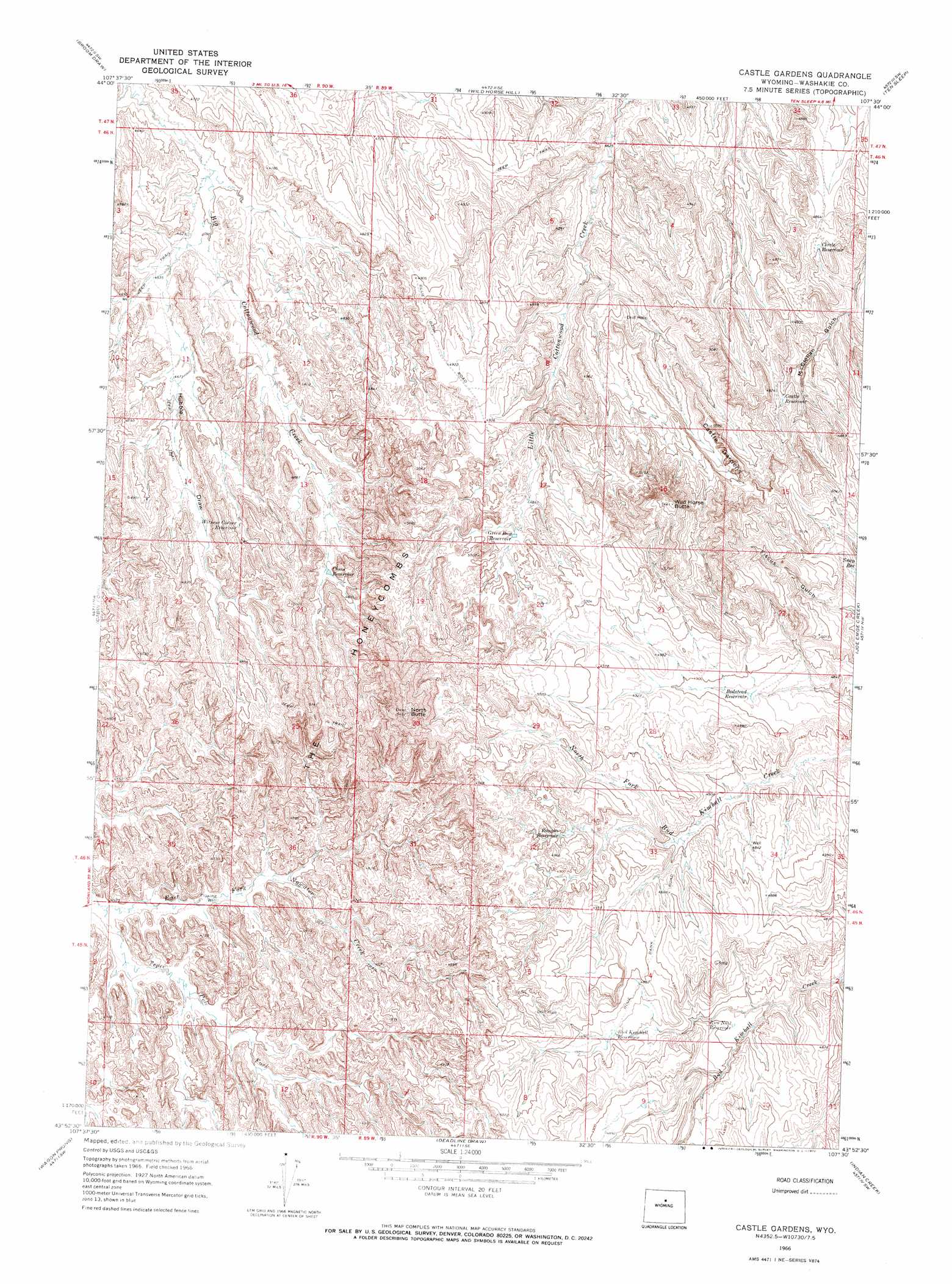
USGS Topo Quad 43107h5 - 1:24,000 scale
| Topo Map Name: | Castle Gardens |
| USGS Topo Quad ID: | 43107h5 |
| Print Size: | ca. 21 1/4" wide x 27" high |
| Southeast Coordinates: | 43.875° N latitude / 107.5° W longitude |
| Map Center Coordinates: | 43.9375° N latitude / 107.5625° W longitude |
| U.S. State: | WY |
| Filename: | o43107h5.jpg |
| Download Map JPG Image: | Castle Gardens topo map 1:24,000 scale |
| Map Type: | Topographic |
| Topo Series: | 7.5´ |
| Map Scale: | 1:24,000 |
| Source of Map Images: | United States Geological Survey (USGS) |
| Alternate Map Versions: |
Castle Gardens WY 1966, updated 1972 Download PDF Buy paper map Castle Gardens WY 2012 Download PDF Buy paper map Castle Gardens WY 2015 Download PDF Buy paper map |
1:24,000 Topo Quads surrounding Castle Gardens
Mcdermotts Butte |
Weintz Draw |
Hyattville |
Pierce Draw |
Brokenback Narrows |
Worland Se |
Broom Draw |
Wild Horse Hill |
Ten Sleep |
Old Maid Gulch |
Banjo Flats East |
Cabin Fork |
Castle Gardens |
Joe Emge Creek |
Big Trails Ne |
Henry Draw |
Wagon Prong |
Deadline Draw |
Indian Creek |
Big Trails |
Packsaddle Creek |
Bader Draw |
Sand Point |
Lightning Ridge |
Mahogany Butte |
> Back to 43107e1 at 1:100,000 scale
> Back to 43106a1 at 1:250,000 scale
> Back to U.S. Topo Maps home
Castle Gardens topo map: Gazetteer
Castle Gardens: Areas
The Honeycombs elevation 1524m 5000′Castle Gardens: Mines
Kimball Draw Mine elevation 1483m 4865′Castle Gardens: Reservoirs
Bedstead Reservoir elevation 1485m 4872′Bud Kimball Reservoir elevation 1484m 4868′
Castle Reservoir elevation 1497m 4911′
Chess Reservoir elevation 1454m 4770′
Circle Reservoir elevation 1466m 4809′
Green Bug Reservoir elevation 1484m 4868′
Rice Number 3 Reservoir elevation 1461m 4793′
Roughs Reservoir elevation 1487m 4878′
Snap Reservoir elevation 1498m 4914′
Witness Corner Reservoir elevation 1455m 4773′
Castle Gardens: Streams
Tepee Pole Draw elevation 1379m 4524′Castle Gardens: Summits
North Butte elevation 1651m 5416′Wild Horse Butte elevation 1660m 5446′
Castle Gardens: Valleys
Hubble Draw elevation 1403m 4603′Castle Gardens digital topo map on disk
Buy this Castle Gardens topo map showing relief, roads, GPS coordinates and other geographical features, as a high-resolution digital map file on DVD:
Eastern Wyoming & Western South Dakota
Buy digital topo maps: Eastern Wyoming & Western South Dakota