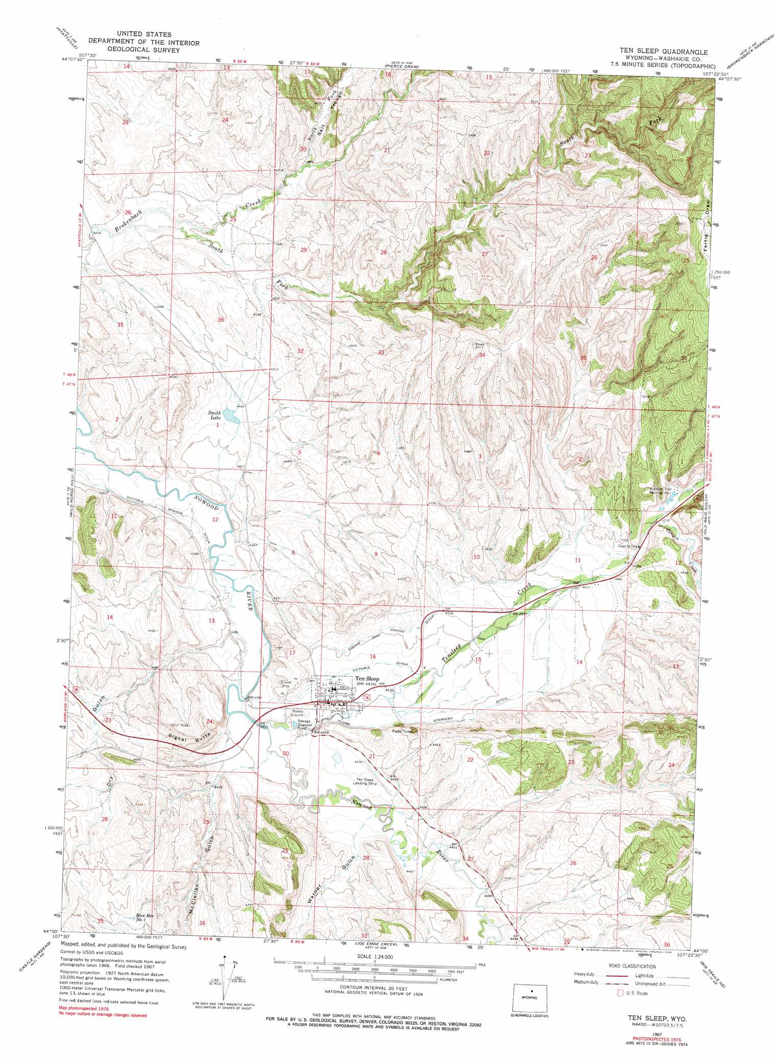
Ten Sleep Topo Map Wyoming
To zoom in, hover over the map of Ten Sleep
USGS Topo Quad 44107a4 - 1:24,000 scale
| Topo Map Name: | Ten Sleep |
| USGS Topo Quad ID: | 44107a4 |
| Print Size: | ca. 21 1/4" wide x 27" high |
| Southeast Coordinates: | 44° N latitude / 107.375° W longitude |
| Map Center Coordinates: | 44.0625° N latitude / 107.4375° W longitude |
| U.S. State: | WY |
| Filename: | o44107a4.jpg |
| Download Map JPG Image: | Ten Sleep topo map 1:24,000 scale |
| Map Type: | Topographic |
| Topo Series: | 7.5´ |
| Map Scale: | 1:24,000 |
| Source of Map Images: | United States Geological Survey (USGS) |
| Alternate Map Versions: |
Ten Sleep WY 1967, updated 1971 Download PDF Buy paper map Ten Sleep WY 1967, updated 1978 Download PDF Buy paper map Ten Sleep WY 2012 Download PDF Buy paper map Ten Sleep WY 2015 Download PDF Buy paper map |
1:24,000 Topo Quads surrounding Ten Sleep
Flitner Reservoir |
Hyatt Ranch |
Allen Draw |
Lake Solitude |
Lake Helen |
Weintz Draw |
Hyattville |
Pierce Draw |
Brokenback Narrows |
Meadowlark Lake |
Broom Draw |
Wild Horse Hill |
Ten Sleep |
Old Maid Gulch |
Onion Gulch |
Cabin Fork |
Castle Gardens |
Joe Emge Creek |
Big Trails Ne |
Monument Hill |
Wagon Prong |
Deadline Draw |
Indian Creek |
Big Trails |
Tallon Spring |
> Back to 44107a1 at 1:100,000 scale
> Back to 44106a1 at 1:250,000 scale
> Back to U.S. Topo Maps home
Ten Sleep topo map: Gazetteer
Ten Sleep: Canals
Fiscus and Vanoni Ditch elevation 1377m 4517′Standish Ditch elevation 1376m 4514′
Victoria Ditch elevation 1357m 4452′
Victoria Winsor Ditch elevation 1333m 4373′
Ten Sleep: Dams
J Smith Dam elevation 1366m 4481′Ten Sleep: Lakes
Smith Lake elevation 1350m 4429′Ten Sleep: Mines
Frison Mine elevation 1342m 4402′Mileski Mine elevation 1355m 4445′
Ten Sleep Area Mine elevation 1395m 4576′
Tensleep Canyon Mine elevation 1354m 4442′
Ten Sleep: Populated Places
Ten Sleep elevation 1349m 4425′Ten Sleep: Reservoirs
J Smith Reservoir elevation 1366m 4481′Rice Reservoir Number 1 elevation 1421m 4662′
Ten Sleep: Streams
Canyon Creek elevation 1435m 4708′North Fork Brokenback Creek elevation 1420m 4658′
South Fork Brokenback Creek elevation 1355m 4445′
Tensleep Creek elevation 1336m 4383′
Ten Sleep: Summits
Signal Butte elevation 1437m 4714′Ten Sleep: Valleys
Dry Gulch elevation 1342m 4402′McClellan Gulch elevation 1348m 4422′
Salt Trough elevation 1423m 4668′
Warner Gulch elevation 1359m 4458′
Ten Sleep digital topo map on disk
Buy this Ten Sleep topo map showing relief, roads, GPS coordinates and other geographical features, as a high-resolution digital map file on DVD:
Eastern Wyoming & Western South Dakota
Buy digital topo maps: Eastern Wyoming & Western South Dakota