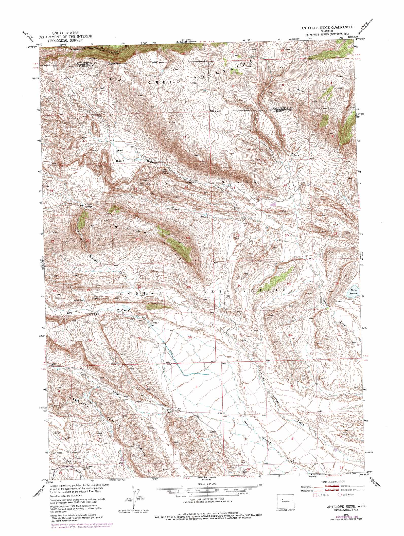
Antelope Ridge Topo Map Wyoming
To zoom in, hover over the map of Antelope Ridge
USGS Topo Quad 43108e8 - 1:24,000 scale
| Topo Map Name: | Antelope Ridge |
| USGS Topo Quad ID: | 43108e8 |
| Print Size: | ca. 21 1/4" wide x 27" high |
| Southeast Coordinates: | 43.5° N latitude / 108.875° W longitude |
| Map Center Coordinates: | 43.5625° N latitude / 108.9375° W longitude |
| U.S. State: | WY |
| Filename: | o43108e8.jpg |
| Download Map JPG Image: | Antelope Ridge topo map 1:24,000 scale |
| Map Type: | Topographic |
| Topo Series: | 7.5´ |
| Map Scale: | 1:24,000 |
| Source of Map Images: | United States Geological Survey (USGS) |
| Alternate Map Versions: |
Antelope Ridge WY 1952, updated 1953 Download PDF Buy paper map Antelope Ridge WY 1952, updated 1976 Download PDF Buy paper map Antelope Ridge WY 1952, updated 1979 Download PDF Buy paper map Antelope Ridge WY 2012 Download PDF Buy paper map Antelope Ridge WY 2015 Download PDF Buy paper map |
1:24,000 Topo Quads surrounding Antelope Ridge
Twin Peaks |
Cottonwood Peak |
Milk Creek |
Twentyone Creek |
Crater Sink |
Monument Peak |
Willow Creek |
Eagle Nest Ranch |
Anchor Reservoir |
Embar |
Johnson Draw |
Circle Ridge |
Antelope Ridge |
Bargee |
Sheep Ridge |
Crowheart Nw |
Crowheart Ne |
Maverick Spring |
Eagle Point |
Shotgun Butte |
Crowheart |
Crowheart Butte |
Lookout Butte Sw |
Lookout Butte |
Pavillion Butte |
> Back to 43108e1 at 1:100,000 scale
> Back to 43108a1 at 1:250,000 scale
> Back to U.S. Topo Maps home
Antelope Ridge topo map: Gazetteer
Antelope Ridge: Basins
Antelope Basin elevation 2087m 6847′Red Basin elevation 2148m 7047′
Antelope Ridge: Dams
Enlargement Pearl Dam elevation 2048m 6719′Antelope Ridge: Mines
Antelope Ridge Area Number One Mine elevation 2003m 6571′Antelope Ridge Area Number Three Mine elevation 2032m 6666′
Antelope Ridge Area Number Two Mine elevation 2056m 6745′
Circle Ridge Anticline Number Four Mine elevation 2288m 7506′
Antelope Ridge: Reservoirs
Enlargement Pearl Reservoir elevation 2048m 6719′Pearl Reservoir elevation 2076m 6811′
Antelope Ridge: Ridges
Antelope Ridge elevation 2320m 7611′Antelope Ridge: Springs
Antelope Springs elevation 2257m 7404′Trickle Spring elevation 2106m 6909′
Antelope Ridge: Valleys
Blue Draw elevation 1946m 6384′Antelope Ridge digital topo map on disk
Buy this Antelope Ridge topo map showing relief, roads, GPS coordinates and other geographical features, as a high-resolution digital map file on DVD: