Fish Lake Topo Map Wyoming
To zoom in, hover over the map of Fish Lake
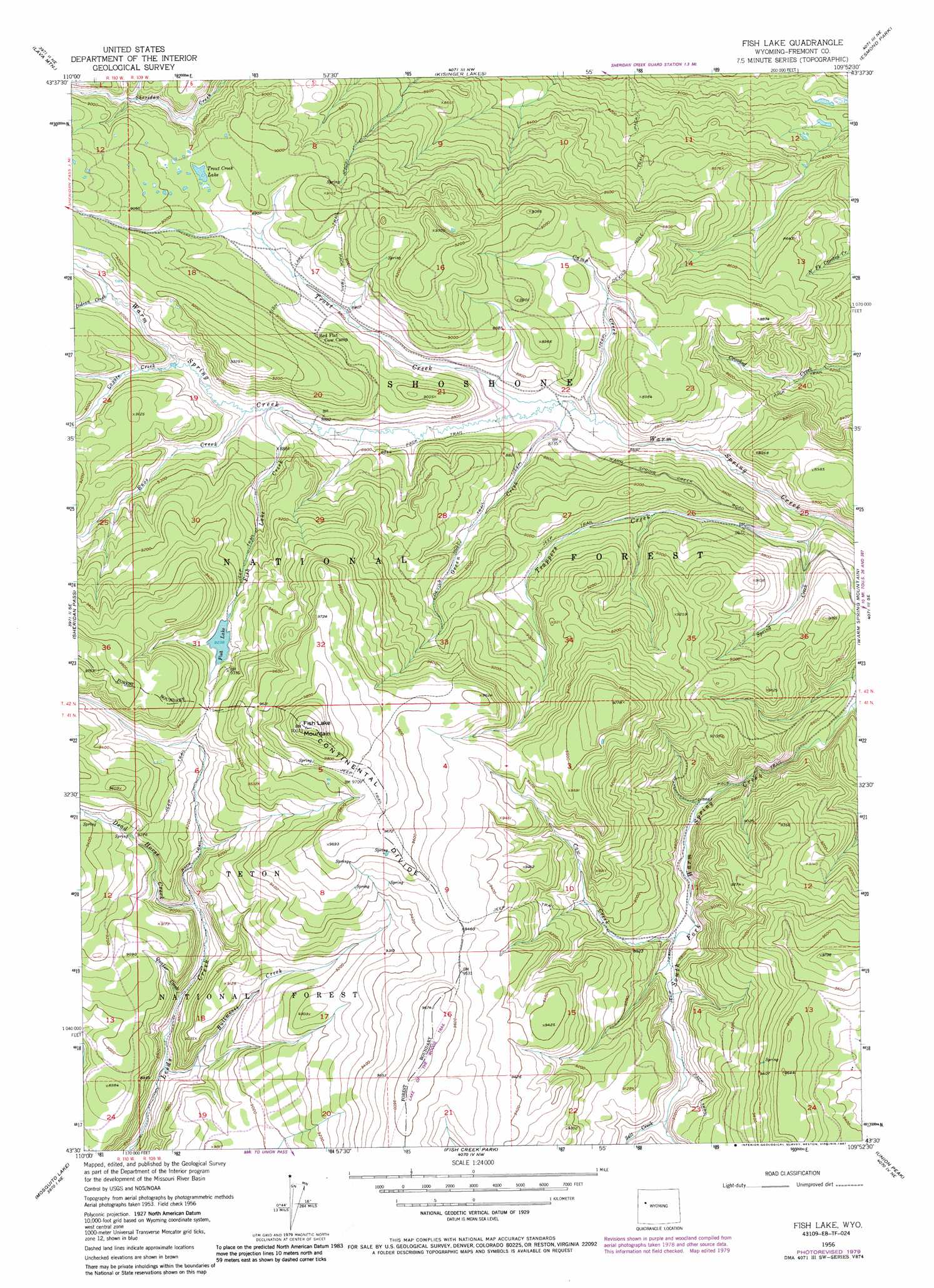
USGS Topo Quad 43109e8 - 1:24,000 scale
| Topo Map Name: | Fish Lake |
| USGS Topo Quad ID: | 43109e8 |
| Print Size: | ca. 21 1/4" wide x 27" high |
| Southeast Coordinates: | 43.5° N latitude / 109.875° W longitude |
| Map Center Coordinates: | 43.5625° N latitude / 109.9375° W longitude |
| U.S. State: | WY |
| Filename: | o43109e8.jpg |
| Download Map JPG Image: | Fish Lake topo map 1:24,000 scale |
| Map Type: | Topographic |
| Topo Series: | 7.5´ |
| Map Scale: | 1:24,000 |
| Source of Map Images: | United States Geological Survey (USGS) |
| Alternate Map Versions: |
Fish Lake WY 1956, updated 1958 Download PDF Buy paper map Fish Lake WY 1956, updated 1963 Download PDF Buy paper map Fish Lake WY 1956, updated 1974 Download PDF Buy paper map Fish Lake WY 1956, updated 1980 Download PDF Buy paper map Fish Lake WY 1956, updated 1987 Download PDF Buy paper map Fish Lake WY 1991, updated 1997 Download PDF Buy paper map Fish Lake WY 2012 Download PDF Buy paper map Fish Lake WY 2015 Download PDF Buy paper map |
| FStopo: | US Forest Service topo Fish Lake is available: Download FStopo PDF Download FStopo TIF |
1:24,000 Topo Quads surrounding Fish Lake
Angle Mountain |
Togwotee Pass |
Dundee Meadows |
Shoshone Pass |
Five Pockets |
Tripod Peak |
Lava Mountain |
Kisinger Lakes |
Esmond Park |
Ramshorn Peak |
Burnt Mountain |
Sheridan Pass |
Fish Lake |
Warm Spring Mountain |
Dubois |
Ouzel Falls |
Mosquito Lake |
Fish Creek Park |
Union Peak |
Simpson Lake |
Tosi Peak |
Klondike Hill |
Big Sheep Mountain |
Green River Lakes |
Downs Mountain |
> Back to 43109e1 at 1:100,000 scale
> Back to 43108a1 at 1:250,000 scale
> Back to U.S. Topo Maps home
Fish Lake topo map: Gazetteer
Fish Lake: Lakes
Fish Lake elevation 2817m 9242′Trout Creek Lake elevation 2719m 8920′
Fish Lake: Streams
Bullmoose Creek elevation 2639m 8658′Camp Creek elevation 2632m 8635′
Cow Creek elevation 2668m 8753′
Coyote Creek elevation 2706m 8877′
Dead Horse Creek elevation 2713m 8900′
Enos Creek elevation 2690m 8825′
Fish Lake Creek elevation 2686m 8812′
Green Creek elevation 2634m 8641′
Indian Creek elevation 2736m 8976′
Quaker Creek elevation 2668m 8753′
Salt Creek elevation 2705m 8874′
Spring Creek elevation 2621m 8599′
Trappers Creek elevation 2595m 8513′
Trout Creek elevation 2637m 8651′
Fish Lake: Summits
Fish Lake Mountain elevation 3065m 10055′Fish Lake: Trails
Devils Hole Trail elevation 2706m 8877′Fish Lake Trail elevation 2719m 8920′
Leeds Creek Trail elevation 2661m 8730′
Fish Lake digital topo map on disk
Buy this Fish Lake topo map showing relief, roads, GPS coordinates and other geographical features, as a high-resolution digital map file on DVD: