Summit Reservoir Topo Map Idaho
To zoom in, hover over the map of Summit Reservoir
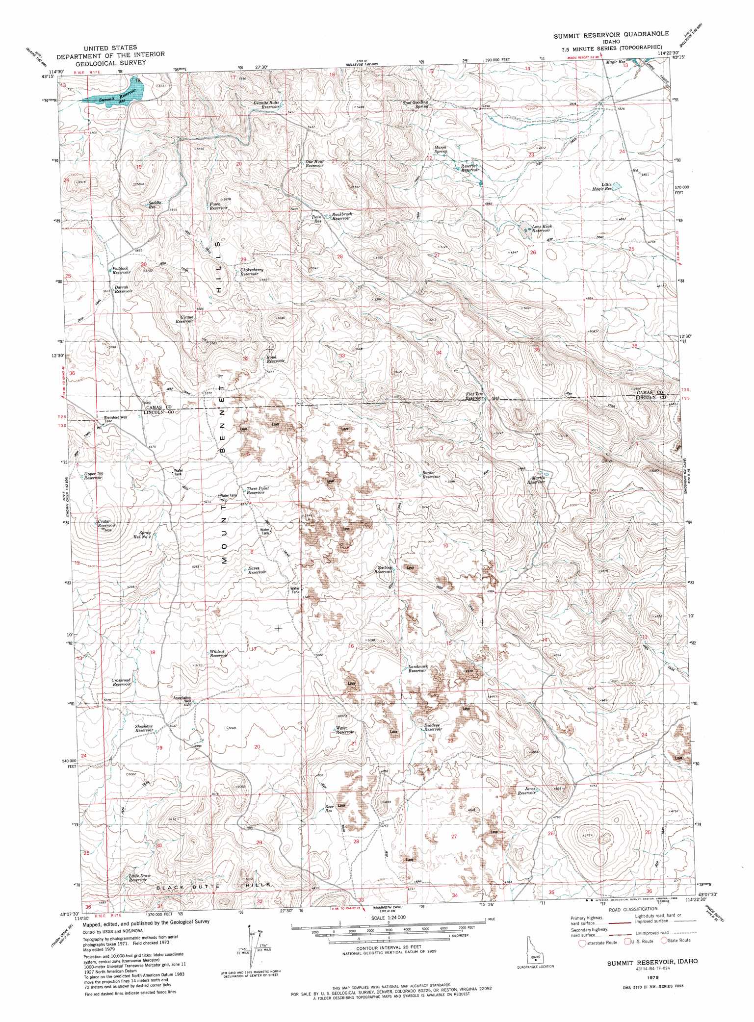
USGS Topo Quad 43114b4 - 1:24,000 scale
| Topo Map Name: | Summit Reservoir |
| USGS Topo Quad ID: | 43114b4 |
| Print Size: | ca. 21 1/4" wide x 27" high |
| Southeast Coordinates: | 43.125° N latitude / 114.375° W longitude |
| Map Center Coordinates: | 43.1875° N latitude / 114.4375° W longitude |
| U.S. State: | ID |
| Filename: | o43114b4.jpg |
| Download Map JPG Image: | Summit Reservoir topo map 1:24,000 scale |
| Map Type: | Topographic |
| Topo Series: | 7.5´ |
| Map Scale: | 1:24,000 |
| Source of Map Images: | United States Geological Survey (USGS) |
| Alternate Map Versions: |
Summit Reservoir ID 1979, updated 1980 Download PDF Buy paper map Summit Reservoir ID 1979, updated 1986 Download PDF Buy paper map Summit Reservoir ID 2010 Download PDF Buy paper map Summit Reservoir ID 2013 Download PDF Buy paper map |
1:24,000 Topo Quads surrounding Summit Reservoir
Cannonball Mountain |
Beaver Creek |
Richardson Summit |
Bellevue |
Seamans Creek |
Spring Creek Reservoir |
Macon |
Magic Reservoir West |
Magic Reservoir East |
Gannett |
Mchan Reservoir |
Thorn Creek Reservoir |
Summit Reservoir |
Shoshone Ice Cave |
Tapper Lake |
Thorn Creek Sw |
Thorn Creek Se |
Mammoth Cave |
Kinzie Butte |
Richfield |
Gooding |
Tunupa |
Shoshone |
Dietrich |
Dietrich Butte |
> Back to 43114a1 at 1:100,000 scale
> Back to 43114a1 at 1:250,000 scale
> Back to U.S. Topo Maps home
Summit Reservoir topo map: Gazetteer
Summit Reservoir: Dams
Dry Wash Dam elevation 1763m 5784′Summit Reservoir: Reservoirs
Bailing Reservoir elevation 1555m 5101′Border Reservoir elevation 1601m 5252′
Buck Brush Reservoir elevation 1635m 5364′
Buckbrush Reservoir elevation 1635m 5364′
Choke Cherry Reservoir elevation 1695m 5561′
Chokecherry Reservoir elevation 1695m 5561′
Cirque Reservoir elevation 1719m 5639′
Crater Reservoir elevation 1700m 5577′
Cross Road Reservoir elevation 1555m 5101′
Crossroad Reservoir elevation 1555m 5101′
Darrah Reservoir elevation 1714m 5623′
Daves Reservoir elevation 1590m 5216′
Deadeye Reservoir elevation 1474m 4835′
Deer Reservoir elevation 1454m 4770′
Fawn Reservoir elevation 1680m 5511′
Flat Tire Reservoir elevation 1538m 5045′
Granite Butte Reservoir elevation 1657m 5436′
Grante Butte Reservoir elevation 1657m 5436′
Jones Reservoir elevation 1450m 4757′
Landmark Reservoir elevation 1505m 4937′
Little Draw Reservoir elevation 1439m 4721′
Little Magic Reservoir elevation 1471m 4826′
Lone Rock Reservoir elevation 1493m 4898′
Martin Reservoir elevation 1511m 4957′
One Hour Reservoir elevation 1674m 5492′
Paddock Reservoir elevation 1716m 5629′
Reserve Reservoir elevation 1501m 4924′
Road Reservoir elevation 1671m 5482′
Saddle Reservoir elevation 1700m 5577′
Shoshone Reservoir elevation 1539m 5049′
Spray Reservoir Number Two elevation 1647m 5403′
Summit Reservoir elevation 1733m 5685′
Three Point Reservoir elevation 1645m 5396′
Twin Reservoir elevation 1636m 5367′
Upper Seven-Hundred Reservoir elevation 1687m 5534′
Water Reservoir elevation 1495m 4904′
Wildcat Reservoir elevation 1560m 5118′
Summit Reservoir: Springs
Marsh Spring elevation 1515m 4970′Tom Gooding Spring elevation 1533m 5029′
Summit Reservoir: Summits
Black Butte elevation 1548m 5078′Summit Reservoir: Wells
Association Well elevation 1531m 5022′Brailsford Well elevation 1701m 5580′
Summit Reservoir digital topo map on disk
Buy this Summit Reservoir topo map showing relief, roads, GPS coordinates and other geographical features, as a high-resolution digital map file on DVD: