Dix Mountain Topo Map New York
To zoom in, hover over the map of Dix Mountain
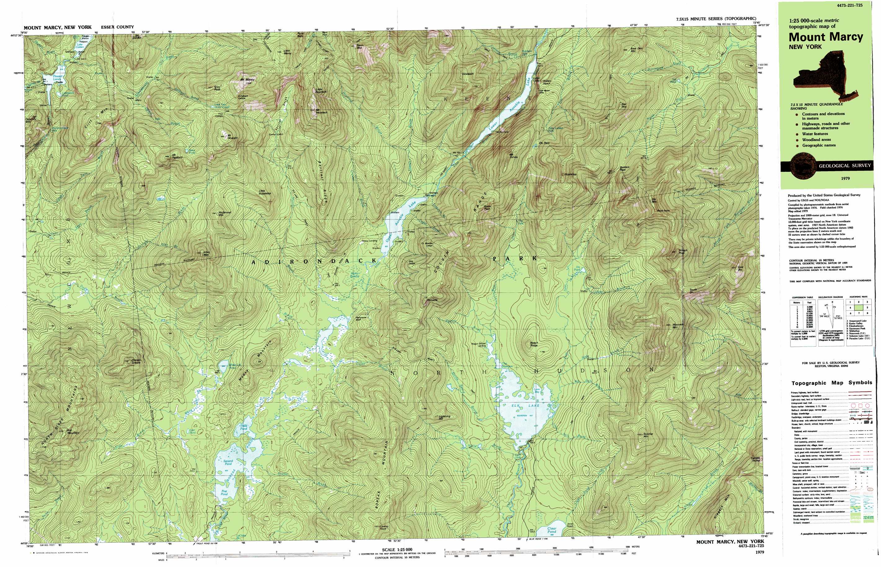
USGS Topo Quad 44073a7 - 1:25,000 scale
| Topo Map Name: | Dix Mountain |
| USGS Topo Quad ID: | 44073a7 |
| Print Size: | ca. 39" wide x 24" high |
| Southeast Coordinates: | 44° N latitude / 73.75° W longitude |
| Map Center Coordinates: | 44.0625° N latitude / 73.875° W longitude |
| U.S. State: | NY |
| Filename: | k44073a7.jpg |
| Download Map JPG Image: | Dix Mountain topo map 1:25,000 scale |
| Map Type: | Topographic |
| Topo Series: | 7.5´x15´ |
| Map Scale: | 1:25,000 |
| Source of Map Images: | United States Geological Survey (USGS) |
| Alternate Map Versions: |
Mount Marcy NY 1979, updated 1979 Download PDF Buy paper map Mount Marcy NY 1999, updated 2001 Download PDF Buy paper map |
1:24,000 Topo Quads surrounding Dix Mountain
Mckenzie Mountain |
Keene |
Lewis |
||
Street Mountain |
Keene Valley |
Elizabethtown |
||
Mount Adams |
Dix Mountain |
Witherbee |
||
Vanderwhacker Mountain |
Blue Ridge |
Paradox Lake |
Eagle Lake |
|
Starbuck Mountain |
Schroon Lake |
Pharaoh Mountain |
Graphite |
> Back to 44073a1 at 1:100,000 scale
> Back to 44072a1 at 1:250,000 scale
> Back to U.S. Topo Maps home
Dix Mountain topo map: Gazetteer
Dix Mountain: Bays
Duck Hole elevation 590m 1935′Indian Cove elevation 603m 1978′
Loon Bay elevation 607m 1991′
Dix Mountain: Beaches
Jones Beach elevation 591m 1938′Dix Mountain: Benches
Cy Beedes Ledge elevation 963m 3159′Otis Ledge elevation 803m 2634′
Dix Mountain: Capes
Beaver Point elevation 843m 2765′Point Balk elevation 1329m 4360′
Dix Mountain: Channels
The Narrows elevation 607m 1991′Dix Mountain: Cliffs
Fish Hawk Cliffs elevation 775m 2542′Panorama Bluff elevation 625m 2050′
Dix Mountain: Falls
Fairy Ladder Falls elevation 971m 3185′Hanging Spear Falls elevation 751m 2463′
Rainbow Falls elevation 598m 1961′
The Falls elevation 699m 2293′
Dix Mountain: Gaps
Elk Pass elevation 1018m 3339′Hunters Pass elevation 991m 3251′
Dix Mountain: Lakes
Boreas Ponds elevation 603m 1978′Deer Pond elevation 637m 2089′
Dial Pond elevation 725m 2378′
Dix Pond elevation 679m 2227′
Elk Lake elevation 607m 1991′
First Pond elevation 603m 1978′
Lake Colden elevation 843m 2765′
Lake Tear of the Clouds elevation 1318m 4324′
Livingston Pond elevation 847m 2778′
Lower Asuable Lake elevation 595m 1952′
Moss Pond elevation 1296m 4251′
Second Pond elevation 603m 1978′
Third Pond elevation 603m 1978′
Upper Ausable Lake elevation 607m 1991′
White Lily Pond elevation 644m 2112′
Dix Mountain: Reservoirs
Flowed Lands elevation 839m 2752′Dix Mountain: Ridges
Bartlett Ridge elevation 1132m 3713′Beech Ridge elevation 772m 2532′
Sawteeth elevation 1255m 4117′
Dix Mountain: Streams
Allen Brook elevation 800m 2624′Big Sally Brook elevation 607m 1991′
Cascade Brook elevation 598m 1961′
Casey Brook elevation 615m 2017′
Cedar Brook elevation 608m 1994′
Clear Pond Inlet elevation 582m 1909′
Cold Brook elevation 844m 2769′
Crystal Brook elevation 607m 1991′
East Inlet elevation 607m 1991′
Feldspar Brook elevation 1015m 3330′
Gravestone Brook elevation 699m 2293′
Guide Board Brook elevation 607m 1991′
Haystack Brook elevation 692m 2270′
Herbert Brook elevation 839m 2752′
LeClaire Brook elevation 595m 1952′
Lillian Brook elevation 676m 2217′
Little Sally Brook elevation 609m 1998′
Marcy Brook elevation 615m 2017′
Nellie Brook elevation 591m 1938′
Sand Brook elevation 616m 2020′
Shanty Brook elevation 600m 1968′
Skylight Brook elevation 639m 2096′
Slide Brook elevation 614m 2014′
Slide Brook elevation 638m 2093′
Snyder Brook elevation 605m 1984′
Stillwater Inlet elevation 607m 1991′
Teakettle Brook elevation 601m 1971′
Uphill Falls Brook elevation 992m 3254′
Virginia Brook elevation 607m 1991′
West Inlet elevation 607m 1991′
White Lily Brook elevation 607m 1991′
Dix Mountain: Summits
Allen Mountain elevation 1311m 4301′Basin Mountain elevation 1468m 4816′
Bear Den Mountain elevation 1030m 3379′
Beck-horn elevation 1455m 4773′
Blake Peak elevation 1212m 3976′
Boreas Mountain elevation 1152m 3779′
Boreas Mountain elevation 1152m 3779′
Cheney Cobble elevation 1120m 3674′
Cliff Mountain elevation 1202m 3943′
Colvin Range elevation 1235m 4051′
Dial Mountain elevation 1215m 3986′
Dix Mountain elevation 1473m 4832′
East Dix elevation 1223m 4012′
Gray Peak elevation 1463m 4799′
Hough Peak elevation 1341m 4399′
Indian Head elevation 812m 2664′
Lightning Hill elevation 846m 2775′
Little Haystack elevation 1421m 4662′
Little Marcy elevation 1438m 4717′
Little Nippletop elevation 1133m 3717′
Macomb Mountain elevation 1336m 4383′
McDonnel Mountain elevation 1200m 3937′
Moose Mountain elevation 823m 2700′
Mount Colvin elevation 1235m 4051′
Mount Haystack elevation 1497m 4911′
Mount Marcy elevation 1617m 5305′
Mount Redfield elevation 1403m 4603′
Mount Skylight elevation 1495m 4904′
Niagara Mountain elevation 913m 2995′
Nippletop elevation 1393m 4570′
Pinnacle elevation 1020m 3346′
Rist Mountain elevation 1170m 3838′
Schofield Cobble elevation 1446m 4744′
Slant Rock elevation 1095m 3592′
South Dix elevation 1242m 4074′
Sunrise Mountain elevation 1099m 3605′
Dix Mountain: Swamps
Marcy Swamp elevation 606m 1988′Dix Mountain: Trails
Dividing Ridge Trail elevation 615m 2017′Dix Trail elevation 1277m 4189′
Elk Lake Marcy Trail elevation 613m 2011′
Range Trail elevation 1408m 4619′
Shorey Short Cut elevation 1253m 4110′
Van Hoevenberg Trail elevation 1396m 4580′
Dix Mountain: Valleys
Panther Gorge elevation 937m 3074′Dix Mountain digital topo map on disk
Buy this Dix Mountain topo map showing relief, roads, GPS coordinates and other geographical features, as a high-resolution digital map file on DVD:
New York, Vermont, Connecticut & Western Massachusetts
Buy digital topo maps: New York, Vermont, Connecticut & Western Massachusetts