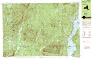
Schroon Lake Topo Map New York
To zoom in, hover over the map of Schroon Lake
USGS Topo Quad 43073g7 - 1:25,000 scale
| Topo Map Name: | Schroon Lake |
| USGS Topo Quad ID: | 43073g7 |
| Print Size: | ca. 39" wide x 24" high |
| Southeast Coordinates: | 43.75° N latitude / 73.75° W longitude |
| Map Center Coordinates: | 43.8125° N latitude / 73.875° W longitude |
| U.S. State: | NY |
| Filename: | k43073g7.jpg |
| Download Map JPG Image: | Schroon Lake topo map 1:25,000 scale |
| Map Type: | Topographic |
| Topo Series: | 7.5´x15´ |
| Map Scale: | 1:25,000 |
| Source of Map Images: | United States Geological Survey (USGS) |
| Alternate Map Versions: |
Schroon Lake NY 1989, updated 1989 Download PDF Buy paper map Schroon Lake NY 1989, updated 1989 Download PDF Buy paper map Schroon Lake NY 1995, updated 1999 Download PDF Buy paper map |
1:24,000 Topo Quads surrounding Schroon Lake
> Back to 43073e1 at 1:100,000 scale
> Back to 43072a1 at 1:250,000 scale
> Back to U.S. Topo Maps home
Schroon Lake topo map: Gazetteer
Schroon Lake: Capes
Gold Course Point elevation 246m 807′Grove Point elevation 259m 849′
Gull Point elevation 246m 807′
Taylors Point elevation 246m 807′
Schroon Lake: Channels
The Narrows elevation 246m 807′Schroon Lake: Cliffs
Moxham Point elevation 583m 1912′Schroon Lake: Islands
Clarks Island elevation 267m 875′Schroon Lake: Lakes
Bailey Pond elevation 502m 1646′Barnes Pond elevation 561m 1840′
Big Pond elevation 391m 1282′
Big Sherman Pond elevation 603m 1978′
Bigsby Pond elevation 476m 1561′
Bullet Pond elevation 385m 1263′
Calahan Pond elevation 437m 1433′
Center Pond elevation 638m 2093′
Duck Pond elevation 520m 1706′
Hewitt Pond elevation 516m 1692′
Horseshoe Pond elevation 381m 1250′
Little Sherman Pond elevation 603m 1978′
Lost Pond elevation 639m 2096′
Marsh Pond elevation 332m 1089′
Minerva Lake elevation 370m 1213′
Moxham Pond elevation 351m 1151′
Muller Pond elevation 447m 1466′
North Pond elevation 381m 1250′
Oliver Pond elevation 456m 1496′
Pat Pond elevation 435m 1427′
Schroon Lake elevation 246m 807′
Stony Pond elevation 633m 2076′
Thurman Pond elevation 271m 889′
Warrens Pond elevation 489m 1604′
Schroon Lake: Populated Places
Adirondack elevation 248m 813′Irishtown elevation 357m 1171′
Loch Muller elevation 510m 1673′
Minerva elevation 423m 1387′
Olmstedville elevation 360m 1181′
Schroon Lake elevation 265m 869′
South Schroon elevation 268m 879′
Schroon Lake: Streams
Alder Brook elevation 300m 984′East Branch Trout Brook elevation 397m 1302′
Falls Brook elevation 354m 1161′
Hewitt Pond Brook elevation 447m 1466′
Horseshoe Pond Brook elevation 246m 807′
Jones Brook elevation 349m 1145′
Kelso Brook elevation 348m 1141′
Mill Brook elevation 249m 816′
Minerva Stream elevation 315m 1033′
North Branch Trout Brook elevation 453m 1486′
Rogers Brook elevation 246m 807′
Ryan Brook elevation 351m 1151′
Sucker Brook elevation 246m 807′
West Branch Trout Brook elevation 397m 1302′
Schroon Lake: Summits
Allard Hill elevation 461m 1512′Beech Hill elevation 664m 2178′
Bigsby Hill elevation 620m 2034′
Catamount Hill elevation 482m 1581′
Cobble Hill elevation 677m 2221′
Green Hill elevation 638m 2093′
Green Mountain elevation 852m 2795′
Hardhack Hill elevation 425m 1394′
Hayes Mountain elevation 834m 2736′
Hedgehog Hill elevation 410m 1345′
Ledge Hill elevation 610m 2001′
Leland Hill elevation 397m 1302′
Merrills Hill elevation 622m 2040′
Moxham Mountain elevation 717m 2352′
Oliver Hill elevation 700m 2296′
Pine Hill elevation 661m 2168′
Poplar Hill elevation 485m 1591′
Quackenbush Hill elevation 453m 1486′
Severance Hill elevation 474m 1555′
Snyder Hill elevation 655m 2148′
Schroon Lake: Valleys
Buck Hollow elevation 479m 1571′Schroon Lake digital topo map on disk
Buy this Schroon Lake topo map showing relief, roads, GPS coordinates and other geographical features, as a high-resolution digital map file on DVD:
New York, Vermont, Connecticut & Western Massachusetts
Buy digital topo maps: New York, Vermont, Connecticut & Western Massachusetts


