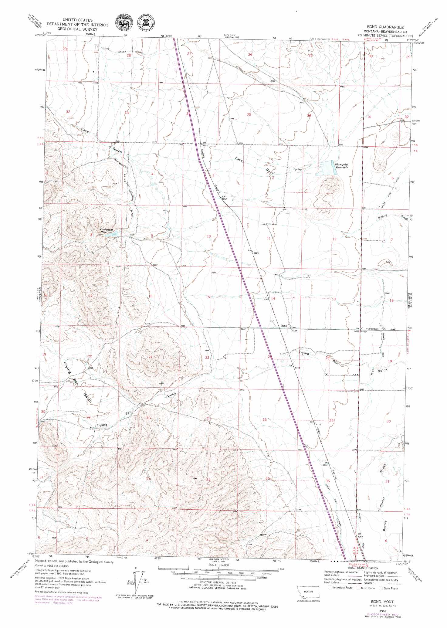
Bond Topo Map Montana
To zoom in, hover over the map of Bond
USGS Topo Quad 45112c6 - 1:24,000 scale
| Topo Map Name: | Bond |
| USGS Topo Quad ID: | 45112c6 |
| Print Size: | ca. 21 1/4" wide x 27" high |
| Southeast Coordinates: | 45.25° N latitude / 112.625° W longitude |
| Map Center Coordinates: | 45.3125° N latitude / 112.6875° W longitude |
| U.S. State: | MT |
| Filename: | o45112c6.jpg |
| Download Map JPG Image: | Bond topo map 1:24,000 scale |
| Map Type: | Topographic |
| Topo Series: | 7.5´ |
| Map Scale: | 1:24,000 |
| Source of Map Images: | United States Geological Survey (USGS) |
| Alternate Map Versions: |
Bond MT 1962, updated 1964 Download PDF Buy paper map Bond MT 1962, updated 1979 Download PDF Buy paper map Bond MT 1997, updated 2002 Download PDF Buy paper map Bond MT 2011 Download PDF Buy paper map Bond MT 2014 Download PDF Buy paper map |
| FStopo: | US Forest Service topo Bond is available: Download FStopo PDF Download FStopo TIF |
1:24,000 Topo Quads surrounding Bond
Mount Tahepia |
Storm Peak |
Earls Gulch |
Nez Perce Hollow |
Twin Bridges Sw |
Torrey Mountain |
Twin Adams Mountain |
Glen |
Block Mountain |
Beaverhead Rock |
Ermont |
Argenta |
Bond |
Glen Se |
Beaverhead Rock Sw |
Bannack |
Burns Mountain |
Dillon West |
Dillon East |
Christensen Ranch |
Eli Spring |
Dalys |
Gallagher Mountain |
Ashbough Canyon |
Elk Gulch |
> Back to 45112a1 at 1:100,000 scale
> Back to 45112a1 at 1:250,000 scale
> Back to U.S. Topo Maps home
Bond topo map: Gazetteer
Bond: Basins
Frying Pan Basin elevation 1648m 5406′Bond: Canals
Guidici Ditch elevation 1540m 5052′West Side Canal elevation 1549m 5082′
Willow Creek Ditch elevation 1687m 5534′
Bond: Dams
Blomquist Reservoir Dam elevation 1561m 5121′Overnight Reservoir Dam elevation 1671m 5482′
Bond: Populated Places
Bond elevation 1574m 5164′Bond: Reservoirs
Blomquist Reservoir elevation 1562m 5124′Overnight Reservoir elevation 1670m 5479′
Bond: Valleys
Cave Gulch elevation 1565m 5134′Bond: Wells
06S08W18CCC_02 Well elevation 1552m 5091′06S09W11DBB_01 Well elevation 1583m 5193′
06S09W13CDD_01 Well elevation 1561m 5121′
06S09W14BDCD01 Well elevation 1582m 5190′
06S09W15BBAB01 Well elevation 1623m 5324′
06S09W23ABB_01 Well elevation 1578m 5177′
07S09W23CACD02 Well elevation 1635m 5364′
Bond digital topo map on disk
Buy this Bond topo map showing relief, roads, GPS coordinates and other geographical features, as a high-resolution digital map file on DVD: