Giant Hill Topo Map Montana
To zoom in, hover over the map of Giant Hill
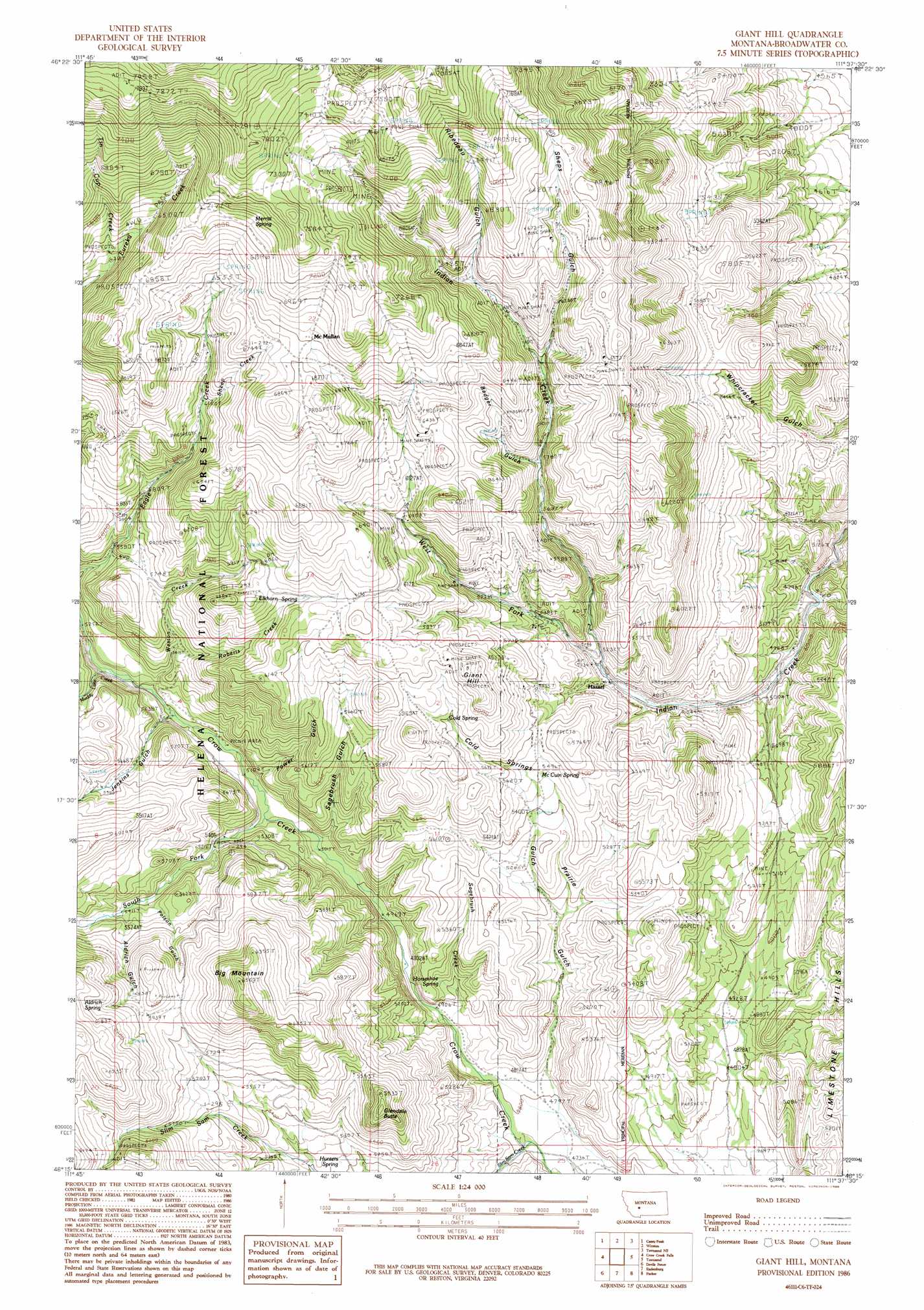
USGS Topo Quad 46111c6 - 1:24,000 scale
| Topo Map Name: | Giant Hill |
| USGS Topo Quad ID: | 46111c6 |
| Print Size: | ca. 21 1/4" wide x 27" high |
| Southeast Coordinates: | 46.25° N latitude / 111.625° W longitude |
| Map Center Coordinates: | 46.3125° N latitude / 111.6875° W longitude |
| U.S. State: | MT |
| Filename: | o46111c6.jpg |
| Download Map JPG Image: | Giant Hill topo map 1:24,000 scale |
| Map Type: | Topographic |
| Topo Series: | 7.5´ |
| Map Scale: | 1:24,000 |
| Source of Map Images: | United States Geological Survey (USGS) |
| Alternate Map Versions: |
Giant Hill MT 1986, updated 1986 Download PDF Buy paper map Giant Hill MT 2001, updated 2004 Download PDF Buy paper map Giant Hill MT 2011 Download PDF Buy paper map Giant Hill MT 2014 Download PDF Buy paper map |
| FStopo: | US Forest Service topo Giant Hill is available: Download FStopo PDF Download FStopo TIF |
1:24,000 Topo Quads surrounding Giant Hill
East Helena |
Louisville |
Canyon Ferry Sw |
Canyon Ferry Se |
Diamond City |
Clancy |
Casey Peak |
Winston |
Townsend Ne |
Gurnett Creek West |
Elkhorn |
Crow Creek Falls |
Giant Hill |
Townsend |
Holker |
Tacoma Park |
Devils Fence |
Radersburg |
Parker |
Toston |
Dunn Creek |
Willow Springs |
Radersburg Sw |
Plunket Lake |
Lombard |
> Back to 46111a1 at 1:100,000 scale
> Back to 46110a1 at 1:250,000 scale
> Back to U.S. Topo Maps home
Giant Hill topo map: Gazetteer
Giant Hill: Mines
Ada Mine elevation 1802m 5912′Badger Gulch Mine elevation 1864m 6115′
BC Number 2 Mine elevation 1844m 6049′
Bluebird Mine elevation 1683m 5521′
Buckeye Mine elevation 1897m 6223′
Bullion King Mine elevation 2294m 7526′
Central Mine elevation 1864m 6115′
Crass Mine elevation 1970m 6463′
Diamond Hill Mine elevation 1653m 5423′
Diamond Hill Mine elevation 1656m 5433′
Dolcoath Mine elevation 1734m 5688′
Gold Bug Mine elevation 1884m 6181′
Iron Mask Mine elevation 1792m 5879′
John L Mine elevation 1846m 6056′
Little Annie Mine elevation 2236m 7335′
Little Giant Mine elevation 1802m 5912′
Mamouth Mine elevation 1838m 6030′
NE NE Section 14 Mine elevation 2245m 7365′
NE NE Section 35 Mine elevation 1710m 5610′
NE NW Section 6 Mine elevation 1607m 5272′
NW SW Section 6 Mine elevation 1585m 5200′
Park Mines elevation 2193m 7194′
Park/New Era Mine elevation 2205m 7234′
Parker Mine elevation 2064m 6771′
Phoenix Mine elevation 1964m 6443′
Queen Bee Mine elevation 1975m 6479′
Ribedeau Mine elevation 1930m 6332′
S and S Mine elevation 2339m 7673′
Saint Louis Mine elevation 2015m 6610′
SE SE Section 7 Mine elevation 1589m 5213′
Shep Mine elevation 2006m 6581′
Spring Hill Mine elevation 1869m 6131′
SW NE Section 27 Mine elevation 2090m 6856′
SW NW Section 13 Mine elevation 2136m 7007′
Vulture Mine elevation 2425m 7956′
W A Clark Mine elevation 1849m 6066′
Giant Hill: Populated Places
Hassel elevation 1598m 5242′McMullan elevation 2076m 6811′
Giant Hill: Post Offices
Hassel Post Office (historical) elevation 1598m 5242′Mason Post Office (historical) elevation 2254m 7395′
Giant Hill: Springs
Aldrich Spring elevation 1854m 6082′Cold Spring elevation 1759m 5770′
Elkhorn Spring elevation 1839m 6033′
Horseshoe Spring elevation 1543m 5062′
Hunters Spring elevation 1594m 5229′
McCuin Spring elevation 1696m 5564′
Merritt Spring elevation 2171m 7122′
Giant Hill: Streams
Jenkins Gulch Creek elevation 1580m 5183′Muddy Lake Creek elevation 1594m 5229′
Roberts Creek elevation 1660m 5446′
Sagebrush Creek elevation 1486m 4875′
Sheep Creek elevation 1868m 6128′
Slim Sam Creek elevation 1448m 4750′
South Fork Crow Creek elevation 1550m 5085′
Tin Cup Creek elevation 1907m 6256′
West Fork Indian Creek elevation 1586m 5203′
Weston Creek elevation 1584m 5196′
Giant Hill: Summits
Big Mountain elevation 1999m 6558′Giant Hill elevation 1889m 6197′
Glendale Butte elevation 1821m 5974′
Giant Hill: Valleys
Aldrich Gulch elevation 1661m 5449′Badger Gulch elevation 1748m 5734′
Cold Springs Gulch elevation 1564m 5131′
Jenkins Gulch elevation 1591m 5219′
Polson Gulch elevation 1642m 5387′
Power Gulch elevation 1581m 5187′
Prairie Gulch elevation 1456m 4776′
Ribedeau Gulch elevation 1908m 6259′
Sagebrush Gulch elevation 1569m 5147′
Sheps Gulch elevation 1861m 6105′
Whipcracker Gulch elevation 1515m 4970′
Giant Hill digital topo map on disk
Buy this Giant Hill topo map showing relief, roads, GPS coordinates and other geographical features, as a high-resolution digital map file on DVD: