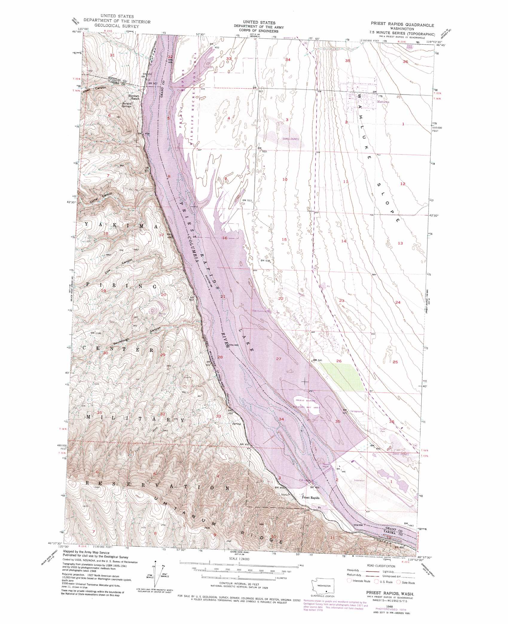
Priest Rapids Topo Map Washington
To zoom in, hover over the map of Priest Rapids
USGS Topo Quad 46119f8 - 1:24,000 scale
| Topo Map Name: | Priest Rapids |
| USGS Topo Quad ID: | 46119f8 |
| Print Size: | ca. 21 1/4" wide x 27" high |
| Southeast Coordinates: | 46.625° N latitude / 119.875° W longitude |
| Map Center Coordinates: | 46.6875° N latitude / 119.9375° W longitude |
| U.S. State: | WA |
| Filename: | o46119f8.jpg |
| Download Map JPG Image: | Priest Rapids topo map 1:24,000 scale |
| Map Type: | Topographic |
| Topo Series: | 7.5´ |
| Map Scale: | 1:24,000 |
| Source of Map Images: | United States Geological Survey (USGS) |
| Alternate Map Versions: |
Priest Rapids WA 1948, updated 1958 Download PDF Buy paper map Priest Rapids WA 1948, updated 1979 Download PDF Buy paper map Priest Rapids WA 2011 Download PDF Buy paper map Priest Rapids WA 2014 Download PDF Buy paper map |
1:24,000 Topo Quads surrounding Priest Rapids
Boylston |
Ginkgo |
Vantage |
Beverly Ne |
Royal City |
Mcdonald Spring |
Doris |
Beverly |
Beverly Se |
Smyrna |
Black Rock Spring Nw |
Black Rock Spring Ne |
Priest Rapids |
Priest Rapids Ne |
Vernita Bridge |
Black Rock Spring Sw |
Black Rock Spring |
Cairn Hope Peak |
Emerson Nipple |
Riverland |
Granger Nw |
Granger Ne |
Sulphur Spring |
Maiden Spring |
Snively Basin |
> Back to 46119e1 at 1:100,000 scale
> Back to 46118a1 at 1:250,000 scale
> Back to U.S. Topo Maps home
Priest Rapids topo map: Gazetteer
Priest Rapids: Airports
Desert Airport elevation 172m 564′Priest Rapids: Dams
Moran Slough Dike Dam elevation 139m 456′Priest Rapids Dam elevation 128m 419′
Priest Rapids: Guts
Moran Slough elevation 139m 456′Priest Rapids: Islands
Goose Island elevation 150m 492′Priest Rapids: Mines
Pozzuolana Mine elevation 263m 862′Priest Rapids: Parks
Priest Rapids Wildlife Recreation Area elevation 153m 501′Priest Rapids: Populated Places
Desert Aire elevation 172m 564′Mattawa elevation 234m 767′
Priest Rapids: Reservoirs
Priest Rapids Lake elevation 128m 419′Priest Rapids: Springs
Borden Springs elevation 189m 620′Priest Rapids: Valleys
Alkali Canyon elevation 154m 505′Corral Canyon elevation 149m 488′
Cow Canyon elevation 163m 534′
Sourdough Canyon elevation 149m 488′
Priest Rapids digital topo map on disk
Buy this Priest Rapids topo map showing relief, roads, GPS coordinates and other geographical features, as a high-resolution digital map file on DVD: