Sulphur Spring Topo Map Washington
To zoom in, hover over the map of Sulphur Spring
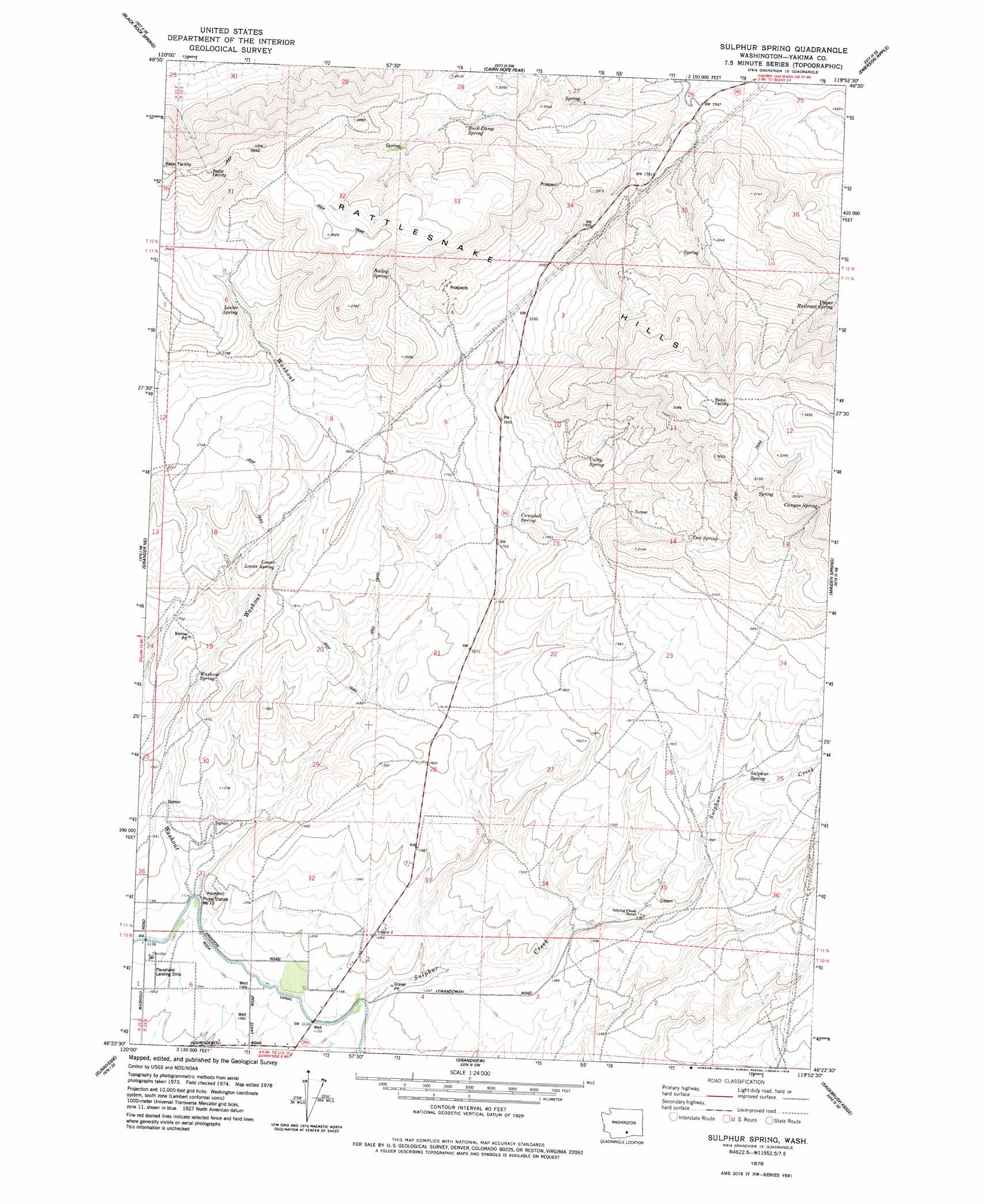
USGS Topo Quad 46119d8 - 1:24,000 scale
| Topo Map Name: | Sulphur Spring |
| USGS Topo Quad ID: | 46119d8 |
| Print Size: | ca. 21 1/4" wide x 27" high |
| Southeast Coordinates: | 46.375° N latitude / 119.875° W longitude |
| Map Center Coordinates: | 46.4375° N latitude / 119.9375° W longitude |
| U.S. State: | WA |
| Filename: | o46119d8.jpg |
| Download Map JPG Image: | Sulphur Spring topo map 1:24,000 scale |
| Map Type: | Topographic |
| Topo Series: | 7.5´ |
| Map Scale: | 1:24,000 |
| Source of Map Images: | United States Geological Survey (USGS) |
| Alternate Map Versions: |
Sulphur Spring WA 1978, updated 1978 Download PDF Buy paper map Sulphur Spring WA 2011 Download PDF Buy paper map Sulphur Spring WA 2013 Download PDF Buy paper map |
1:24,000 Topo Quads surrounding Sulphur Spring
Black Rock Spring Nw |
Black Rock Spring Ne |
Priest Rapids |
Priest Rapids Ne |
Vernita Bridge |
Black Rock Spring Sw |
Black Rock Spring |
Cairn Hope Peak |
Emerson Nipple |
Riverland |
Granger Nw |
Granger Ne |
Sulphur Spring |
Maiden Spring |
Snively Basin |
Granger |
Sunnyside |
Grandview |
Sagebrush Ridge |
Snipes Creek |
Bluelight Nw |
Mabton West |
Mabton East |
Prosser |
Whitstran |
> Back to 46119a1 at 1:100,000 scale
> Back to 46118a1 at 1:250,000 scale
> Back to U.S. Topo Maps home
Sulphur Spring topo map: Gazetteer
Sulphur Spring: Springs
Bailey Spring elevation 792m 2598′Buck Camp Spring elevation 679m 2227′
Campbell Spring elevation 573m 1879′
Canyon Spring elevation 927m 3041′
Colby Spring elevation 684m 2244′
Lower Lozier Spring elevation 533m 1748′
Lozier Spring elevation 705m 2312′
Sulphur Spring elevation 567m 1860′
Two Spring elevation 744m 2440′
Upper Railroad Spring elevation 706m 2316′
Washout Spring elevation 452m 1482′
Sulphur Spring: Streams
Washout elevation 340m 1115′Sulphur Spring digital topo map on disk
Buy this Sulphur Spring topo map showing relief, roads, GPS coordinates and other geographical features, as a high-resolution digital map file on DVD: