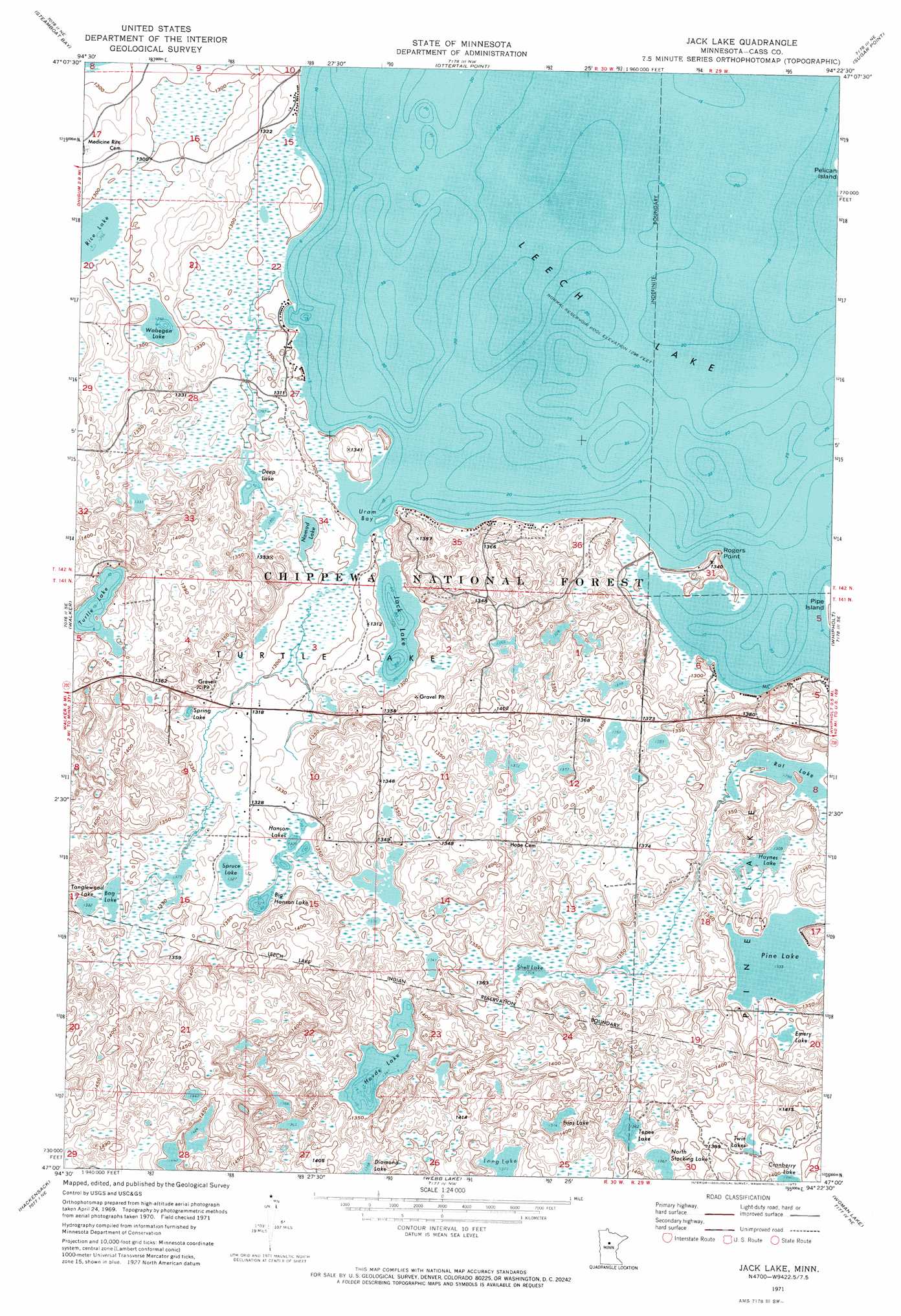
Jack Lake Topo Map Minnesota
To zoom in, hover over the map of Jack Lake
USGS Topo Quad 47094a4 - 1:24,000 scale
| Topo Map Name: | Jack Lake |
| USGS Topo Quad ID: | 47094a4 |
| Print Size: | ca. 21 1/4" wide x 27" high |
| Southeast Coordinates: | 47° N latitude / 94.375° W longitude |
| Map Center Coordinates: | 47.0625° N latitude / 94.4375° W longitude |
| U.S. State: | MN |
| Filename: | p47094a4.jpg |
| Download Map JPG Image: | Jack Lake topo map 1:24,000 scale |
| Map Type: | Orthophoto |
| Topo Series: | 7.5´ |
| Map Scale: | 1:24,000 |
| Source of Map Images: | United States Geological Survey (USGS) |
| Alternate Map Versions: |
Jack Lake MN 1971, updated 1973 Download PDF Buy paper map Jack Lake MN 1971, updated 1974 Download PDF Buy paper map Jack Lake MN 1996, updated 1998 Download PDF Buy paper map Jack Lake MN 2011 Download PDF Buy paper map Jack Lake MN 2013 Download PDF Buy paper map Jack Lake MN 2016 Download PDF Buy paper map |
| FStopo: | US Forest Service topo Jack Lake is available: Download FStopo PDF Download FStopo TIF |
1:24,000 Topo Quads surrounding Jack Lake
Steamboat Lake |
Pike Bay |
Sucker Lakes |
Portage Lake |
Bena |
Benedict |
Steamboat Bay |
Ottertail Point |
Sugar Point |
Federal Dam |
Akeley |
Walker |
Jack Lake |
Whipholt |
Town Line Lake |
Crystal Lake |
Hackensack |
Webb Lake |
Woman Lake |
Longville |
Oshawa |
Backus |
Mildred |
Lake Ada |
Stewart Lake |
> Back to 47094a1 at 1:100,000 scale
> Back to 47094a1 at 1:250,000 scale
> Back to U.S. Topo Maps home
Jack Lake topo map: Gazetteer
Jack Lake: Bays
Uram Bay elevation 395m 1295′Jack Lake: Capes
Rogers Point elevation 401m 1315′Jack Lake: Lakes
Bag Lake elevation 406m 1332′Big Hanson Lake elevation 405m 1328′
Deep Lake elevation 398m 1305′
Emery Lake elevation 410m 1345′
Hanson Lakes elevation 404m 1325′
Haynes Lake elevation 398m 1305′
Hovde Lake elevation 409m 1341′
Ivins Lake elevation 419m 1374′
Jack Lake elevation 395m 1295′
Nomad Lake elevation 396m 1299′
North Stocking Lake elevation 415m 1361′
Pine Lake elevation 407m 1335′
Rice Lake elevation 395m 1295′
Shell Lake elevation 407m 1335′
Spring Lake elevation 401m 1315′
Spruce Lake elevation 405m 1328′
Tanglewood Lake elevation 406m 1332′
Tepee Lake elevation 415m 1361′
Turtle Lake elevation 410m 1345′
Twin Lakes elevation 425m 1394′
Wabegon Lake elevation 396m 1299′
Jack Lake: Reservoirs
Bag Lake Impoundment elevation 403m 1322′Jack Lake digital topo map on disk
Buy this Jack Lake topo map showing relief, roads, GPS coordinates and other geographical features, as a high-resolution digital map file on DVD: