Upper Jocko Lake Topo Map Montana
To zoom in, hover over the map of Upper Jocko Lake
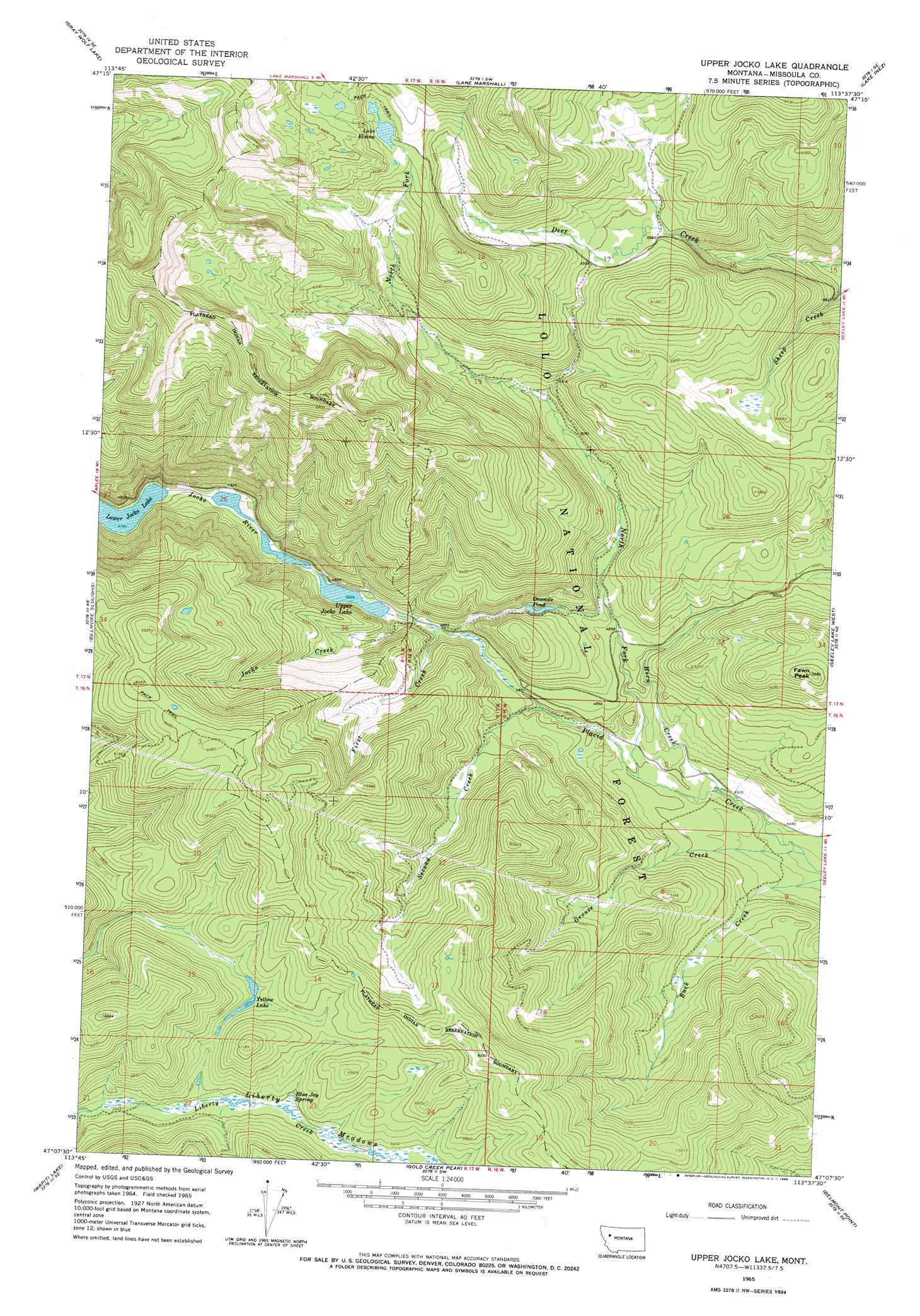
USGS Topo Quad 47113b6 - 1:24,000 scale
| Topo Map Name: | Upper Jocko Lake |
| USGS Topo Quad ID: | 47113b6 |
| Print Size: | ca. 21 1/4" wide x 27" high |
| Southeast Coordinates: | 47.125° N latitude / 113.625° W longitude |
| Map Center Coordinates: | 47.1875° N latitude / 113.6875° W longitude |
| U.S. State: | MT |
| Filename: | o47113b6.jpg |
| Download Map JPG Image: | Upper Jocko Lake topo map 1:24,000 scale |
| Map Type: | Topographic |
| Topo Series: | 7.5´ |
| Map Scale: | 1:24,000 |
| Source of Map Images: | United States Geological Survey (USGS) |
| Alternate Map Versions: |
Upper Jocko Lake MT 1965, updated 1968 Download PDF Buy paper map Upper Jocko Lake MT 1999, updated 2003 Download PDF Buy paper map Upper Jocko Lake MT 2011 Download PDF Buy paper map Upper Jocko Lake MT 2014 Download PDF Buy paper map |
| FStopo: | US Forest Service topo Upper Jocko Lake is available: Download FStopo PDF Download FStopo TIF |
1:24,000 Topo Quads surrounding Upper Jocko Lake
Mount Harding |
Hemlock Lake |
Cygnet Lake |
Holland Lake |
Shaw Creek |
Saint Marys Lake |
Gray Wolf Lake |
Lake Marshall |
Lake Inez |
Morrell Lake |
Gold Creek |
Belmore Sloughs |
Upper Jocko Lake |
Seeley Lake West |
Seeley Lake East |
Stuart Peak |
Wapiti Lake |
Gold Creek Peak |
Belmont Point |
Salmon Lake |
Northeast Missoula |
Blue Point |
Sunflower Mountain |
Potomac |
Greenough |
> Back to 47113a1 at 1:100,000 scale
> Back to 47112a1 at 1:250,000 scale
> Back to U.S. Topo Maps home
Upper Jocko Lake topo map: Gazetteer
Upper Jocko Lake: Dams
Black Lake Dam elevation 1528m 5013′Upper Jocko Lake: Flats
Liberty Meadows elevation 1707m 5600′Upper Jocko Lake: Lakes
Lake Elsina elevation 1924m 6312′Onemile Pond elevation 1510m 4954′
Upper Jocko Lake elevation 1473m 4832′
Yellow Lake elevation 1731m 5679′
Upper Jocko Lake: Reservoirs
Black Lake elevation 1528m 5013′Upper Jocko Lake: Springs
Blue Jay Spring elevation 1706m 5597′Upper Jocko Lake: Streams
First Creek elevation 1447m 4747′Grouse Creek elevation 1353m 4438′
Horn Creek elevation 1378m 4520′
Jocko Creek elevation 1473m 4832′
North Fork Placid Creek elevation 1402m 4599′
Second Creek elevation 1446m 4744′
Upper Jocko Lake: Summits
Fawn Peak elevation 1734m 5688′Upper Jocko Lake digital topo map on disk
Buy this Upper Jocko Lake topo map showing relief, roads, GPS coordinates and other geographical features, as a high-resolution digital map file on DVD: