Conners Island Topo Map Minnesota
To zoom in, hover over the map of Conners Island
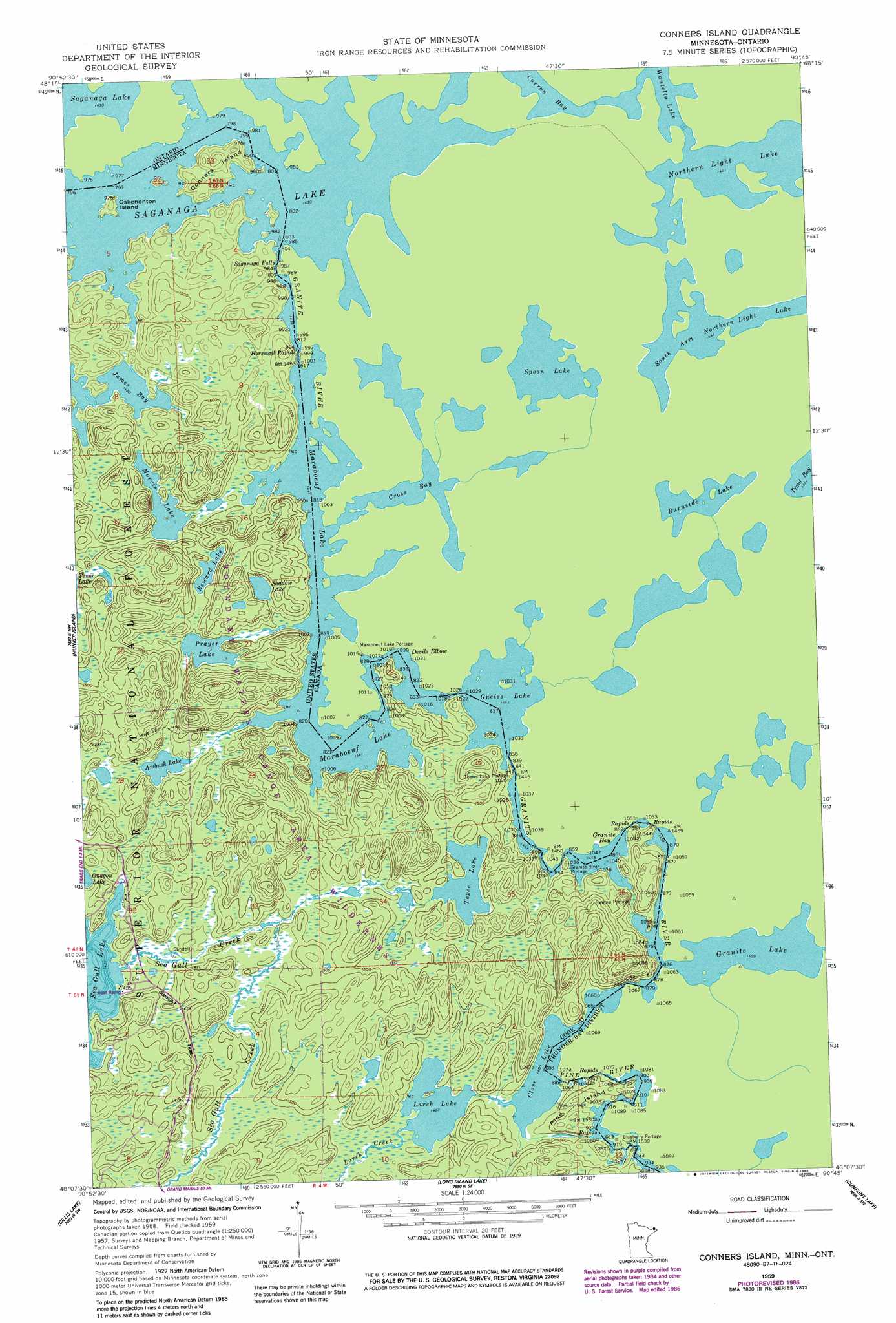
USGS Topo Quad 48090b7 - 1:24,000 scale
| Topo Map Name: | Conners Island |
| USGS Topo Quad ID: | 48090b7 |
| Print Size: | ca. 21 1/4" wide x 27" high |
| Southeast Coordinates: | 48.125° N latitude / 90.75° W longitude |
| Map Center Coordinates: | 48.1875° N latitude / 90.8125° W longitude |
| U.S. State: | MN |
| Filename: | o48090b7.jpg |
| Download Map JPG Image: | Conners Island topo map 1:24,000 scale |
| Map Type: | Topographic |
| Topo Series: | 7.5´ |
| Map Scale: | 1:24,000 |
| Source of Map Images: | United States Geological Survey (USGS) |
| Alternate Map Versions: |
Conners Island MN 1959, updated 1962 Download PDF Buy paper map Conners Island MN 1959, updated 1966 Download PDF Buy paper map Conners Island MN 1959, updated 1986 Download PDF Buy paper map Conners Island MN 2011 Download PDF Buy paper map Conners Island MN 2013 Download PDF Buy paper map Conners Island MN 2016 Download PDF Buy paper map |
| FStopo: | US Forest Service topo Conners Island is available: Download FStopo PDF Download FStopo TIF |
1:24,000 Topo Quads surrounding Conners Island
Ester Lake |
Munker Island |
Conners Island |
||
Ogishkemuncie Lake |
Gillis Lake |
Long Island Lake |
Gunflint Lake |
South Lake |
Lake Polly |
Kelso Mountain |
Cherokee Lake |
Brule Lake |
Eagle Mountain |
> Back to 48090a1 at 1:100,000 scale
> Back to 48090a1 at 1:250,000 scale
> Back to U.S. Topo Maps home
Conners Island topo map: Gazetteer
Conners Island: Bays
Granite Bay elevation 444m 1456′James Bay elevation 436m 1430′
Red Sucker Bay elevation 436m 1430′
Conners Island: Bends
Devils Elbow elevation 439m 1440′Conners Island: Falls
Saganaga Falls elevation 439m 1440′Conners Island: Islands
Conners Island elevation 457m 1499′Oskenonton Island elevation 447m 1466′
Pine Island elevation 470m 1541′
Conners Island: Lakes
Ambush Lake elevation 442m 1450′Clove Lake elevation 445m 1459′
Gneiss Lake elevation 436m 1430′
Larch Lake elevation 447m 1466′
Maraboeuf Lake elevation 437m 1433′
Morris Lake elevation 444m 1456′
Prayer Lake elevation 444m 1456′
Reward Lake elevation 449m 1473′
Shadow Lake elevation 455m 1492′
Tepee Lake elevation 454m 1489′
Conners Island: Rapids
Horsetail Rapids elevation 441m 1446′Conners Island: Streams
Granite River elevation 436m 1430′Larch Creek elevation 445m 1459′
Pine River elevation 453m 1486′
Sea Gull Creek elevation 443m 1453′
Conners Island: Trails
Gneiss Lake Portage elevation 444m 1456′Gneiss Trail elevation 443m 1453′
Granite River Portage elevation 445m 1459′
Maraboeuf Lake Portage elevation 453m 1486′
Pine Portage elevation 466m 1528′
Conners Island digital topo map on disk
Buy this Conners Island topo map showing relief, roads, GPS coordinates and other geographical features, as a high-resolution digital map file on DVD: