Loomis Topo Map Washington
To zoom in, hover over the map of Loomis
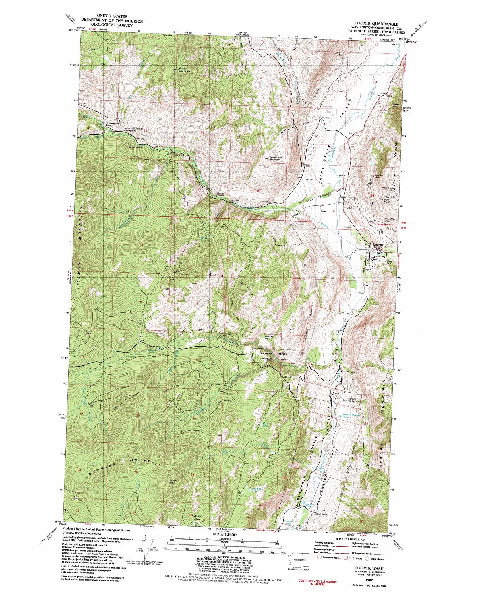
USGS Topo Quad 48119g6 - 1:24,000 scale
| Topo Map Name: | Loomis |
| USGS Topo Quad ID: | 48119g6 |
| Print Size: | ca. 21 1/4" wide x 27" high |
| Southeast Coordinates: | 48.75° N latitude / 119.625° W longitude |
| Map Center Coordinates: | 48.8125° N latitude / 119.6875° W longitude |
| U.S. State: | WA |
| Filename: | o48119g6.jpg |
| Download Map JPG Image: | Loomis topo map 1:24,000 scale |
| Map Type: | Topographic |
| Topo Series: | 7.5´ |
| Map Scale: | 1:24,000 |
| Source of Map Images: | United States Geological Survey (USGS) |
| Alternate Map Versions: |
Loomis WA 1982, updated 1982 Download PDF Buy paper map Loomis WA 2011 Download PDF Buy paper map Loomis WA 2014 Download PDF Buy paper map |
1:24,000 Topo Quads surrounding Loomis
Horseshoe Basin |
Hurley Peak |
Nighthawk |
Bullfrog Mountain |
Oroville |
Corral Butte |
Duncan Ridge |
Loomis |
Enterprise |
Ellisforde |
Tiffany Mountain |
Coxit Mountain |
Blue Goat Mountain |
Aeneas Lake |
Tonasket |
Old Baldy |
Conconully West |
Conconully East |
Riverside |
Keystone |
> Back to 48119e1 at 1:100,000 scale
> Back to 48118a1 at 1:250,000 scale
> Back to U.S. Topo Maps home
Loomis topo map: Gazetteer
Loomis: Basins
Doney Basin elevation 1246m 4087′Loomis: Flats
Hercules Flat elevation 774m 2539′Tunnel Flat elevation 454m 1489′
Loomis: Lakes
Jim Black Lake elevation 994m 3261′Renn Lake elevation 948m 3110′
Stadium Lake elevation 458m 1502′
Loomis: Mines
Black Bear Mine elevation 817m 2680′Security Mine elevation 613m 2011′
War Eagle Mine elevation 719m 2358′
Loomis: Populated Places
Loomis elevation 401m 1315′Loomis: Streams
Cecil Creek elevation 420m 1377′Chopaka Creek elevation 364m 1194′
Deer Creek elevation 562m 1843′
Huckleberry Creek elevation 703m 2306′
Katasa Creek elevation 906m 2972′
North Fork Toats Coulee Creek elevation 836m 2742′
Olie Creek elevation 808m 2650′
Redman Creek elevation 637m 2089′
South Fork Toats Coulee Creek elevation 852m 2795′
Three Forks elevation 1113m 3651′
Toats Coulee Creek elevation 391m 1282′
Loomis: Summits
Douglas Mountain elevation 1615m 5298′Gold Hill elevation 1288m 4225′
Quartz Mountain elevation 1327m 4353′
Rattlesnake Mountain elevation 812m 2664′
Loomis: Tunnels
Palmer Mountain Tunnel elevation 501m 1643′Loomis: Valleys
Rattlesnake Draw elevation 384m 1259′Security Draw elevation 471m 1545′
Loomis digital topo map on disk
Buy this Loomis topo map showing relief, roads, GPS coordinates and other geographical features, as a high-resolution digital map file on DVD: