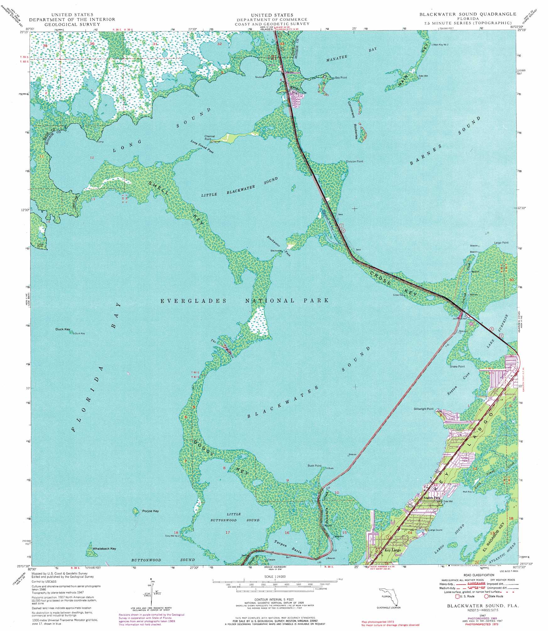
Blackwater Sound Topo Map Florida
To zoom in, hover over the map of Blackwater Sound
USGS Topo Quad 25080b4 - 1:24,000 scale
| Topo Map Name: | Blackwater Sound |
| USGS Topo Quad ID: | 25080b4 |
| Print Size: | ca. 21 1/4" wide x 27" high |
| Southeast Coordinates: | 25.125° N latitude / 80.375° W longitude |
| Map Center Coordinates: | 25.1875° N latitude / 80.4375° W longitude |
| U.S. State: | FL |
| Filename: | O25080B4.jpg |
| Download Map JPG Image: | Blackwater Sound topo map 1:24,000 scale |
| Map Type: | Topographic |
| Topo Series: | 7.5´ |
| Map Scale: | 1:24,000 |
| Source of Map Images: | United States Geological Survey (USGS) |
| Alternate Map Versions: |
Blackwater Sound FL 1947, updated 1967 Download PDF Buy paper map Blackwater Sound FL 1947, updated 1970 Download PDF Buy paper map Blackwater Sound FL 1947, updated 1976 Download PDF Buy paper map Blackwater Sound FL 1949 Download PDF Buy paper map Blackwater Sound FL 2012 Download PDF Buy paper map Blackwater Sound FL 2015 Download PDF Buy paper map |
1:24,000 Topo Quads surrounding Blackwater Sound
Long Pine Key |
Royal Palm Ranger Station |
Homestead |
Arsenicker Keys |
Elliott Key |
Taylor Slough |
Royal Palm Ranger Station Se |
Glades |
Card Sound |
Pacific Reef |
Madeira Bay |
Joe Bay |
Blackwater Sound |
Garden Cove |
|
Calusa Keys |
Tavernier |
Rock Harbor |
||
Upper Matecumbe Key |
Plantation Key |
> Back to 25080a1 at 1:100,000 scale
> Back to 25080a1 at 1:250,000 scale
> Back to U.S. Topo Maps home
Blackwater Sound topo map: Gazetteer
Blackwater Sound: Bays
Barnes Sound elevation 0m 0′Blackwater Sound elevation 0m 0′
Largo Sound elevation 0m 0′
Little Blackwater Sound elevation 0m 0′
Little Buttonwood Sound elevation 0m 0′
Long Sound elevation 0m 0′
Sexton Cove elevation 0m 0′
Blackwater Sound: Canals
Marvin D Adams Waterway elevation 3m 9′Blackwater Sound: Capes
Bay Point elevation 0m 0′Bush Point elevation 0m 0′
Channel Point elevation 0m 0′
Division Point elevation 0m 0′
Largo Point elevation 0m 0′
Snake Point elevation 0m 0′
Stellrecht Point elevation 0m 0′
Blackwater Sound: Channels
Blackwater Pass elevation 0m 0′Long Sound Pass elevation 0m 0′
The Boggies elevation 0m 0′
Blackwater Sound: Guts
Dusenbury Creek elevation 0m 0′Jewfish Creek elevation 0m 0′
Manatee Creek elevation 0m 0′
Shell Creek elevation 0m 0′
Blackwater Sound: Islands
Boggy Key elevation 0m 0′Cormorant Rookeries elevation 0m 0′
Cross Key elevation 0m 0′
Duck Key elevation 0m 0′
Main Key elevation 0m 0′
Porjoe Key elevation 0m 0′
Shell Key elevation 0m 0′
Whaleback Key elevation 0m 0′
Blackwater Sound: Lakes
Lake Surprise elevation 0m 0′Blackwater Sound: Populated Places
Anglers Park elevation 3m 9′Jewfish elevation -1m -4′
Manatee Cove Mobile Home Park elevation 0m 0′
Blackwater Sound digital topo map on disk
Buy this Blackwater Sound topo map showing relief, roads, GPS coordinates and other geographical features, as a high-resolution digital map file on DVD: