West Lake Topo Map Florida
To zoom in, hover over the map of West Lake
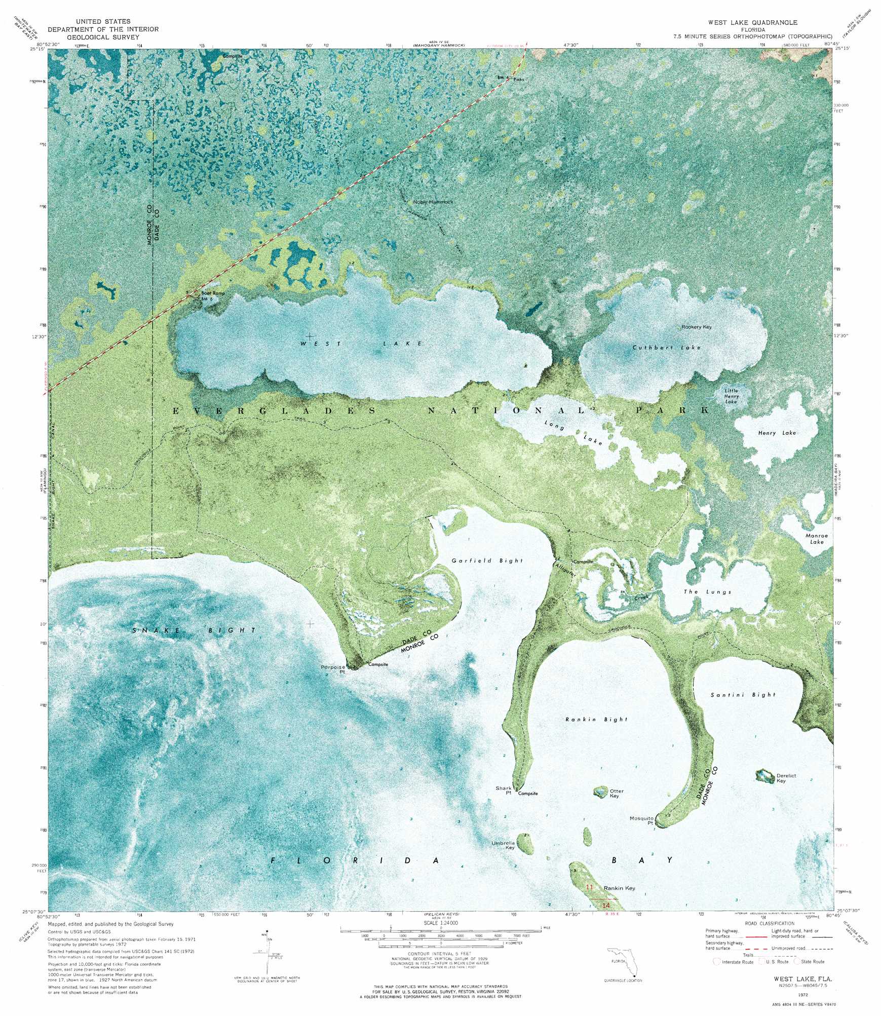
USGS Topo Quad 25080b7 - 1:24,000 scale
| Topo Map Name: | West Lake |
| USGS Topo Quad ID: | 25080b7 |
| Print Size: | ca. 21 1/4" wide x 27" high |
| Southeast Coordinates: | 25.125° N latitude / 80.75° W longitude |
| Map Center Coordinates: | 25.1875° N latitude / 80.8125° W longitude |
| U.S. State: | FL |
| Filename: | P25080B7.jpg |
| Download Map JPG Image: | West Lake topo map 1:24,000 scale |
| Map Type: | Orthophoto |
| Topo Series: | 7.5´ |
| Map Scale: | 1:24,000 |
| Source of Map Images: | United States Geological Survey (USGS) |
| Alternate Map Versions: |
West Lake FL 2012 Download PDF Buy paper map West Lake FL 2015 Download PDF Buy paper map |
1:24,000 Topo Quads surrounding West Lake
Harney River |
Tarpon Bay |
Pa-Hay-Okee Lookout Tower |
Long Pine Key |
Royal Palm Ranger Station |
Whitewater Bay West |
Whitewater Bay East |
Mahogany Hammock |
Taylor Slough |
Royal Palm Ranger Station Se |
Lake Ingraham East |
Flamingo |
West Lake |
Madeira Bay |
Joe Bay |
Sandy Key |
Clive Key |
Pelican Keys |
Calusa Keys |
Tavernier |
East Bahia Honda Key Ne |
Schooner Bank |
Buchanan Keys |
Upper Matecumbe Key |
Plantation Key |
> Back to 25080a1 at 1:100,000 scale
> Back to 25080a1 at 1:250,000 scale
> Back to U.S. Topo Maps home
West Lake topo map: Gazetteer
West Lake: Bays
Garfield Bight elevation 0m 0′Rankin Bight elevation 0m 0′
Santini Bight elevation 0m 0′
Snake Bight elevation 0m 0′
West Lake: Canals
Snake Bight Canal elevation 0m 0′West Lake: Capes
Mosquito Point elevation 0m 0′Porpoise Point elevation 0m 0′
Shark Point elevation 0m 0′
Shark Point elevation 0m 0′
West Lake: Guts
Alligator Creek elevation 0m 0′West Lake: Islands
Derelict Key elevation 0m 0′Noble Hammock elevation -1m -4′
Otter Key elevation 0m 0′
Rankin Key elevation 0m 0′
Rookery Key elevation 0m 0′
Umbrella Key elevation 0m 0′
West Lake: Lakes
Cuthbert Lake elevation 0m 0′Henry Lake elevation 0m 0′
Little Henry Lake elevation 0m 0′
Long Lake elevation 0m 0′
The Lungs elevation 0m 0′
West Lake elevation 0m 0′
West Lake: Trails
Crocodile Point Trail elevation 0m 0′Noble Hammock Canoe Trail elevation -1m -4′
West Lake digital topo map on disk
Buy this West Lake topo map showing relief, roads, GPS coordinates and other geographical features, as a high-resolution digital map file on DVD: