Sarasota Topo Map Florida
To zoom in, hover over the map of Sarasota
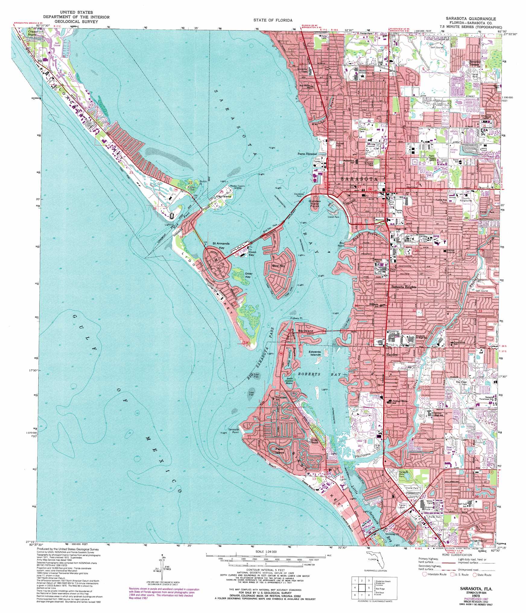
USGS Topo Quad 27082c5 - 1:24,000 scale
| Topo Map Name: | Sarasota |
| USGS Topo Quad ID: | 27082c5 |
| Print Size: | ca. 21 1/4" wide x 27" high |
| Southeast Coordinates: | 27.25° N latitude / 82.5° W longitude |
| Map Center Coordinates: | 27.3125° N latitude / 82.5625° W longitude |
| U.S. State: | FL |
| Filename: | O27082C5.jpg |
| Download Map JPG Image: | Sarasota topo map 1:24,000 scale |
| Map Type: | Topographic |
| Topo Series: | 7.5´ |
| Map Scale: | 1:24,000 |
| Source of Map Images: | United States Geological Survey (USGS) |
| Alternate Map Versions: |
Sarasota FL 1944, updated 1961 Download PDF Buy paper map Sarasota FL 1973, updated 1975 Download PDF Buy paper map Sarasota FL 1973, updated 1987 Download PDF Buy paper map Sarasota FL 1973, updated 1992 Download PDF Buy paper map Sarasota FL 1994, updated 2000 Download PDF Buy paper map Sarasota FL 2012 Download PDF Buy paper map Sarasota FL 2015 Download PDF Buy paper map |
1:24,000 Topo Quads surrounding Sarasota
Egmont Key |
Anna Maria |
Palmetto |
Parrish |
Rye |
Bradenton Beach |
Bradenton |
Lorraine |
Verna |
|
Sarasota |
Bee Ridge |
Old Myakka |
||
Bird Keys |
Laurel |
Lower Myakka Lake |
||
Venice |
Myakka River |
> Back to 27082a1 at 1:100,000 scale
> Back to 27082a1 at 1:250,000 scale
> Back to U.S. Topo Maps home
Sarasota topo map: Gazetteer
Sarasota: Airports
Memorial Hospital Heliport elevation 5m 16′Wallace 1 Heliport elevation 7m 22′
Sarasota: Bays
Coconut Bayou elevation 1m 3′Roberts Bay elevation 0m 0′
Sarasota Bay elevation 0m 0′
South Coconut Bayou elevation 0m 0′
Sarasota: Beaches
Crescent Beach elevation 1m 3′Indian Beach elevation 1m 3′
Sarasota Beach elevation 1m 3′
Siesta Beach elevation 1m 3′
Sarasota: Bridges
Ringlin Bridge elevation 0m 0′Sarasota: Canals
Grand Canal elevation 1m 3′Sarasota: Capes
Bay Point elevation 2m 6′Bird Key Point elevation 1m 3′
Fishery Point elevation 0m 0′
Golden Gate Point elevation 1m 3′
Quick Point elevation 0m 0′
Sarasota Point elevation 1m 3′
Stickney Point elevation 1m 3′
Sarasota: Channels
Big Sarasota Pass elevation 0m 0′New Pass elevation 0m 0′
Sarasota: Guts
Hamsen Bayou elevation 1m 3′Hudson Bayou elevation 1m 3′
Whitaker Bayou elevation 1m 3′
Sarasota: Islands
Bay Island elevation 1m 3′Bird Key elevation 1m 3′
City Island elevation 1m 3′
Coon Key elevation 1m 3′
Edwards Islands elevation 2m 6′
Lido Key elevation 1m 3′
Otter Key elevation 1m 3′
Palm Island elevation 1m 3′
Saint Armands Key elevation 1m 3′
Siesta Key elevation 0m 0′
Sarasota: Parks
Bee Ridge Park elevation 7m 22′Causeway Park elevation 2m 6′
Coolidge Park elevation 1m 3′
Gillespie Park elevation 7m 22′
Island Park elevation 2m 6′
Lukewood Park elevation 4m 13′
Payne Park elevation 8m 26′
Pioneer Park elevation 4m 13′
South Lido County Park elevation 1m 3′
Tuttle Avenue Park elevation 9m 29′
Sarasota: Populated Places
Bailey Hall elevation 1m 3′Beverley Terrace elevation 11m 36′
Gulf Gate Estates elevation 4m 13′
North Sarasota elevation 11m 36′
Ridge Wood Heights elevation 7m 22′
Sarasota elevation 7m 22′
Sarasota Heights elevation 5m 16′
Siesta Key elevation 1m 3′
South Sarasota elevation 4m 13′
South Trail elevation 7m 22′
Southgate elevation 0m 0′
Sarasota: Streams
Philippe Creek elevation 0m 0′Sarasota digital topo map on disk
Buy this Sarasota topo map showing relief, roads, GPS coordinates and other geographical features, as a high-resolution digital map file on DVD: