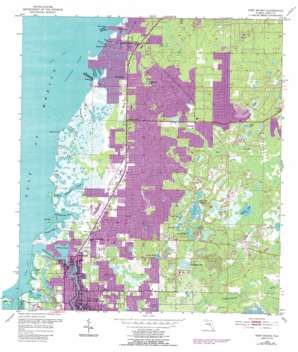
Port Richey Topo Map Florida
To zoom in, hover over the map of Port Richey
USGS Topo Quad 28082c6 - 1:24,000 scale
| Topo Map Name: | Port Richey |
| USGS Topo Quad ID: | 28082c6 |
| Print Size: | ca. 21 1/4" wide x 27" high |
| Southeast Coordinates: | 28.25° N latitude / 82.625° W longitude |
| Map Center Coordinates: | 28.3125° N latitude / 82.6875° W longitude |
| U.S. State: | FL |
| Filename: | O28082C6.jpg |
| Download Map JPG Image: | Port Richey topo map 1:24,000 scale |
| Map Type: | Topographic |
| Topo Series: | 7.5´ |
| Map Scale: | 1:24,000 |
| Source of Map Images: | United States Geological Survey (USGS) |
| Alternate Map Versions: |
Port Richey FL 1954, updated 1955 Download PDF Buy paper map Port Richey FL 1954, updated 1965 Download PDF Buy paper map Port Richey FL 1954, updated 1988 Download PDF Buy paper map Port Richey FL 1954, updated 1988 Download PDF Buy paper map Port Richey FL 1998, updated 2002 Download PDF Buy paper map Port Richey FL 2012 Download PDF Buy paper map Port Richey FL 2015 Download PDF Buy paper map |
1:24,000 Topo Quads surrounding Port Richey
Bayport |
Weeki Wachee Spring |
Brooksville |
||
Aripeka |
Port Richey Ne |
Masaryktown |
||
Port Richey |
Fivay Junction |
Ehren |
||
Tarpon Springs |
Elfers |
Odessa |
Lutz |
|
Dunedin |
Oldsmar |
Citrus Park |
Sulphur Springs |
> Back to 28082a1 at 1:100,000 scale
> Back to 28082a1 at 1:250,000 scale
> Back to U.S. Topo Maps home
Port Richey topo map: Gazetteer
Port Richey: Airports
Hidden Lake Airport elevation 6m 19′Port Richey: Bays
Boggy Bay elevation 0m 0′Port Richey: Capes
Bayonet Point elevation 0m 0′Stake Creek Point elevation 0m 0′
Yellow Point elevation 0m 0′
Port Richey: Guts
Hope Bayou elevation 0m 0′Port Richey: Islands
Cow Key elevation 0m 0′Shine Island elevation 1m 3′
Skeleton Key elevation 0m 0′
Port Richey: Lakes
Dead Cypress Lake elevation 5m 16′Frierson Lakes elevation 5m 16′
Garden Lake elevation 5m 16′
Hidden Lake elevation 7m 22′
Hudson Lake elevation 6m 19′
Lake Worrell elevation 5m 16′
Lighter Bayou elevation 1m 3′
Millers Bayou elevation 0m 0′
Orange Lake elevation 3m 9′
Orchid Lake elevation 4m 13′
Scout Lake elevation 4m 13′
Smokehouse Pond elevation 3m 9′
Worley Lakes elevation 6m 19′
Yellow Lake elevation 6m 19′
Port Richey: Parks
Werner-Boyce Salt Springs State Park elevation 1m 3′Port Richey: Populated Places
Bayonet Point elevation 9m 29′Hudson elevation 3m 9′
Jasmine Estates elevation 1m 3′
Port Richey elevation 3m 9′
Port Richey: Post Offices
Port Richey Post Office elevation 3m 9′Port Richey: Streams
Britches Creek elevation 0m 0′Cow Creek elevation 0m 0′
Doorshutter Creek elevation 0m 0′
Double Hammock Creek elevation 0m 0′
Hudson Creek elevation 0m 0′
Long Grassy Creek elevation 0m 0′
Oyster Creek elevation 0m 0′
Pithlachascotee River elevation 0m 0′
Pound Net Creek elevation 0m 0′
Rocky Creek elevation 0m 0′
Salt Springs Run elevation 0m 0′
Sponge Crawl Creek elevation 0m 0′
Stake Creek elevation 0m 0′
Wigwam Creek elevation 0m 0′
Port Richey: Summits
Buzzards Roost elevation 1m 3′Port Richey: Swamps
Bear Creek elevation 6m 19′Port Richey digital topo map on disk
Buy this Port Richey topo map showing relief, roads, GPS coordinates and other geographical features, as a high-resolution digital map file on DVD:


