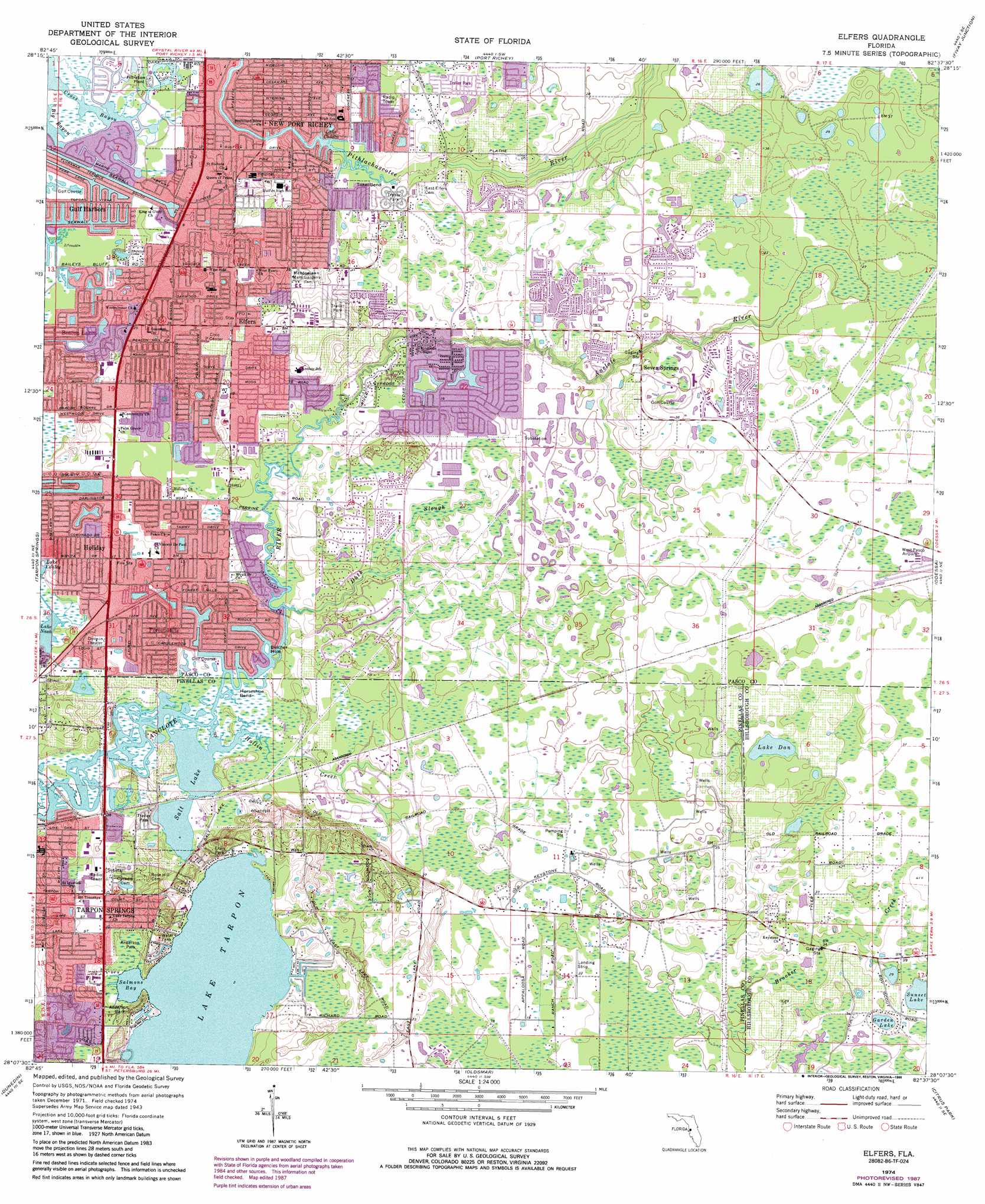
Elfers Topo Map Florida
To zoom in, hover over the map of Elfers
USGS Topo Quad 28082b6 - 1:24,000 scale
| Topo Map Name: | Elfers |
| USGS Topo Quad ID: | 28082b6 |
| Print Size: | ca. 21 1/4" wide x 27" high |
| Southeast Coordinates: | 28.125° N latitude / 82.625° W longitude |
| Map Center Coordinates: | 28.1875° N latitude / 82.6875° W longitude |
| U.S. State: | FL |
| Filename: | O28082B6.jpg |
| Download Map JPG Image: | Elfers topo map 1:24,000 scale |
| Map Type: | Topographic |
| Topo Series: | 7.5´ |
| Map Scale: | 1:24,000 |
| Source of Map Images: | United States Geological Survey (USGS) |
| Alternate Map Versions: |
Elfers FL 1943, updated 1957 Download PDF Buy paper map Elfers FL 1943, updated 1965 Download PDF Buy paper map Elfers FL 1974, updated 1975 Download PDF Buy paper map Elfers FL 1974, updated 1988 Download PDF Buy paper map Elfers FL 1998, updated 2001 Download PDF Buy paper map Elfers FL 2012 Download PDF Buy paper map Elfers FL 2015 Download PDF Buy paper map |
1:24,000 Topo Quads surrounding Elfers
Aripeka |
Port Richey Ne |
Masaryktown |
||
Port Richey |
Fivay Junction |
Ehren |
||
Tarpon Springs |
Elfers |
Odessa |
Lutz |
|
Dunedin |
Oldsmar |
Citrus Park |
Sulphur Springs |
|
Clearwater |
Safety Harbor |
Gandy Bridge |
Tampa |
> Back to 28082a1 at 1:100,000 scale
> Back to 28082a1 at 1:250,000 scale
> Back to U.S. Topo Maps home
Elfers topo map: Gazetteer
Elfers: Airports
HCA-New Port Richey Hospital Heliport elevation 5m 16′Tampa Bay Executive Airport elevation 12m 39′
Torii Field elevation 6m 19′
Elfers: Bays
Salmons Bay elevation 0m 0′Elfers: Bends
Horseshoe Bend elevation 0m 0′Tokel Bend elevation 1m 3′
Elfers: Guts
Big Bayou elevation 0m 0′Cross Bayou elevation 0m 0′
Duck Slough elevation 6m 19′
Salt Lake elevation 0m 0′
Elfers: Lakes
Belcher Hole elevation 1m 3′Garden Lake elevation 8m 26′
Lake Chasco elevation 5m 16′
Lake Dan elevation 9m 29′
Lake Nash elevation 0m 0′
Sunset Lake elevation 9m 29′
Elfers: Parks
Anderson Park elevation 1m 3′Dorsett Park elevation 4m 13′
Highland Nature Park elevation 11m 36′
Richard Ervin Park elevation 4m 13′
Tarpon Sports Complex elevation 5m 16′
Elfers: Populated Places
Beacon Lakes elevation 4m 13′Elfers elevation 12m 39′
Forest Hills elevation 7m 22′
Garden Lake elevation 8m 26′
Holiday elevation 5m 16′
Keystone Park elevation 12m 39′
New Port Richey elevation 5m 16′
Seven Springs elevation 9m 29′
Trinity elevation 6m 19′
Elfers: Post Offices
Holiday Post Office elevation 3m 9′New Port Richey Post Office elevation 7m 22′
Tarpon Springs Post Office elevation 2m 6′
Elfers: Streams
Hollin Creek elevation 0m 0′Elfers digital topo map on disk
Buy this Elfers topo map showing relief, roads, GPS coordinates and other geographical features, as a high-resolution digital map file on DVD: