Satsuma Topo Map Texas
To zoom in, hover over the map of Satsuma
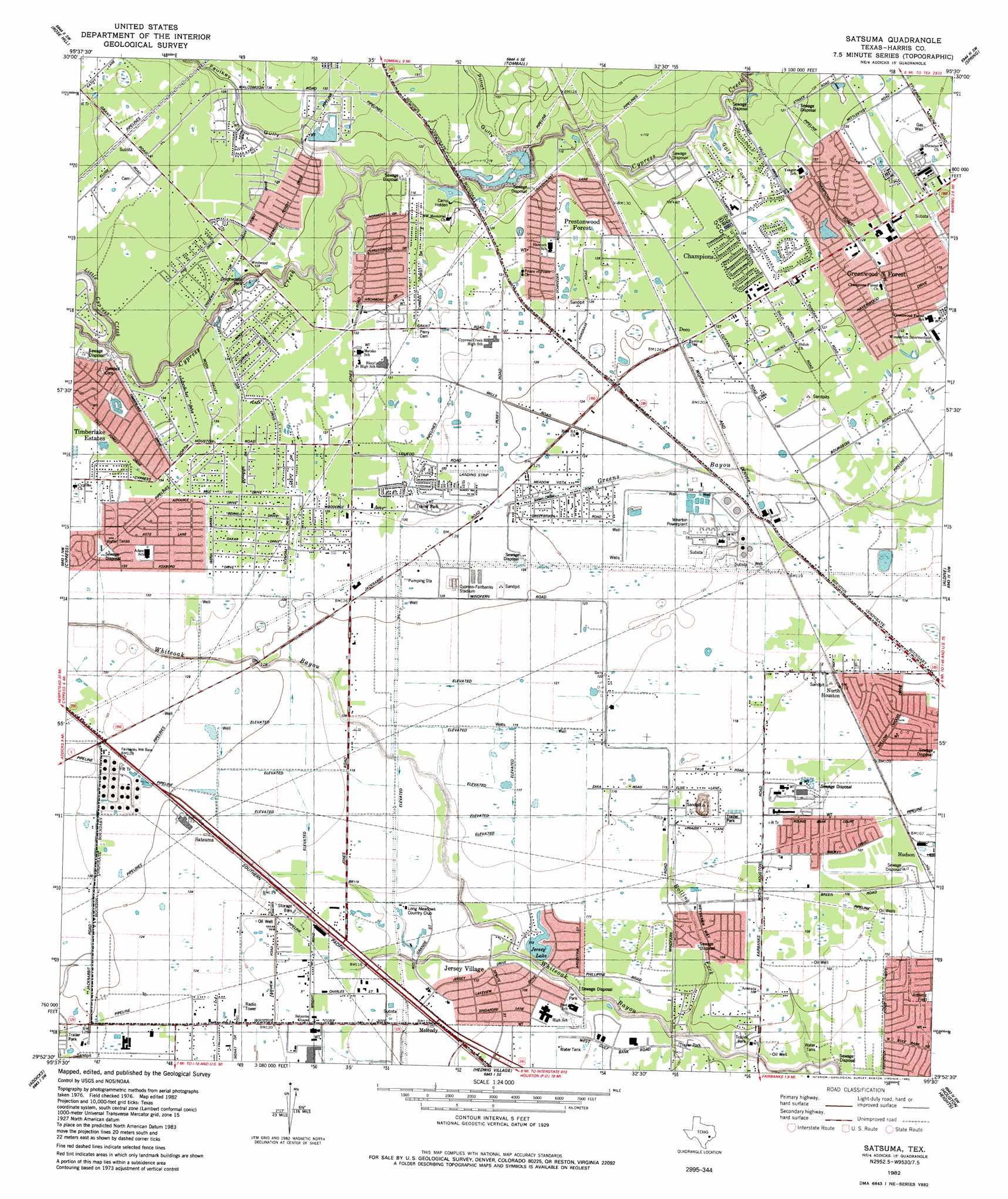
USGS Topo Quad 29095h5 - 1:24,000 scale
| Topo Map Name: | Satsuma |
| USGS Topo Quad ID: | 29095h5 |
| Print Size: | ca. 21 1/4" wide x 27" high |
| Southeast Coordinates: | 29.875° N latitude / 95.5° W longitude |
| Map Center Coordinates: | 29.9375° N latitude / 95.5625° W longitude |
| U.S. State: | TX |
| Filename: | o29095h5.jpg |
| Download Map JPG Image: | Satsuma topo map 1:24,000 scale |
| Map Type: | Topographic |
| Topo Series: | 7.5´ |
| Map Scale: | 1:24,000 |
| Source of Map Images: | United States Geological Survey (USGS) |
| Alternate Map Versions: |
Satsuma TX 1916 Download PDF Buy paper map Satsuma TX 1916 Download PDF Buy paper map Satsuma TX 1916, updated 1961 Download PDF Buy paper map Satsuma TX 1970, updated 1973 Download PDF Buy paper map Satsuma TX 1982, updated 1982 Download PDF Buy paper map Satsuma TX 1982, updated 1982 Download PDF Buy paper map Satsuma TX 1995, updated 2000 Download PDF Buy paper map Satsuma TX 2010 Download PDF Buy paper map Satsuma TX 2013 Download PDF Buy paper map Satsuma TX 2016 Download PDF Buy paper map |
1:24,000 Topo Quads surrounding Satsuma
Magnolia West |
Magnolia East |
Oklahoma |
Tamina |
Outlaw Pond |
Hockley |
Rose Hill |
Tomball |
Spring |
Maedan |
Warren Lake |
Cypress |
Satsuma |
Aldine |
Humble |
Katy |
Addicks |
Hedwig Village |
Houston Heights |
Settegast |
Richmond Ne |
Clodine |
Alief |
Bellaire |
Park Place |
> Back to 29095e1 at 1:100,000 scale
> Back to 29094a1 at 1:250,000 scale
> Back to U.S. Topo Maps home
Satsuma topo map: Gazetteer
Satsuma: Airports
Action Number 2 Heliport elevation 36m 118′Flying Acres Airport elevation 41m 134′
Hickory Hollow Heliport elevation 35m 114′
Steeplechase Heliport elevation 37m 121′
Satsuma: Dams
Marshall Dam elevation 30m 98′Neuhaus Lake Dam elevation 38m 124′
Satsuma: Lakes
Jersey Lake elevation 34m 111′Satsuma: Oilfields
Fairbanks Oil Field elevation 31m 101′Satsuma: Parks
Aerodrome Willowbrook elevation 38m 124′Cypress Community Christian School Football and Baseball Fields elevation 40m 131′
Grant Woods Park elevation 38m 124′
Henry Park elevation 31m 101′
Pridgeon Stadium elevation 40m 131′
Willowbrook Sports Complex elevation 39m 127′
Satsuma: Populated Places
Barwood elevation 41m 134′Bell Meads elevation 37m 121′
Brookhollow West elevation 31m 101′
Canterbury Forest elevation 42m 137′
Cashel Forest elevation 36m 118′
Champion Park elevation 39m 127′
Champions East elevation 38m 124′
Creekside Estates South elevation 30m 98′
Cutten Green elevation 36m 118′
Cypress Creek Estates elevation 40m 131′
Cypress Glen elevation 40m 131′
Deco elevation 38m 124′
Grantwood elevation 40m 131′
Greenwood Forest elevation 37m 121′
Harvest Meadows elevation 38m 124′
Hastings Green elevation 40m 131′
Hudson elevation 33m 108′
Huntwick Forest elevation 38m 124′
Jersey Village elevation 32m 104′
Lakewood West elevation 39m 127′
Melendy elevation 34m 111′
Mill Ridge North elevation 41m 134′
Norchester elevation 39m 127′
North Houston elevation 35m 114′
Northwest Green elevation 34m 111′
Northwest Park elevation 34m 111′
Pedegrel Forest elevation 34m 111′
Ravensway elevation 41m 134′
Ravensway South elevation 42m 137′
Sabacen Park elevation 42m 137′
Satsuma elevation 38m 124′
Tallowwood elevation 40m 131′
Tower Oak Bend elevation 41m 134′
Tower Oak Plaza elevation 41m 134′
Tower Oaks elevation 41m 134′
Tower Oaks Meadows elevation 41m 134′
Turtle Lake elevation 38m 124′
Westbank elevation 33m 108′
Western Estates elevation 40m 131′
Willowood elevation 33m 108′
Winchester Country elevation 36m 118′
Windfern Forest elevation 33m 108′
Woodedge Village elevation 40m 131′
Woodland Oaks elevation 31m 101′
Woodland Trails North elevation 30m 98′
Woods of Wimbledon elevation 38m 124′
Satsuma: Reservoirs
Marshall Lake elevation 30m 98′Satsuma: Streams
Little Cypress Creek elevation 34m 111′Rolling Fork elevation 25m 82′
Satsuma: Valleys
Faulkey Gully elevation 32m 104′Pillot Gully elevation 30m 98′
Satsuma digital topo map on disk
Buy this Satsuma topo map showing relief, roads, GPS coordinates and other geographical features, as a high-resolution digital map file on DVD: