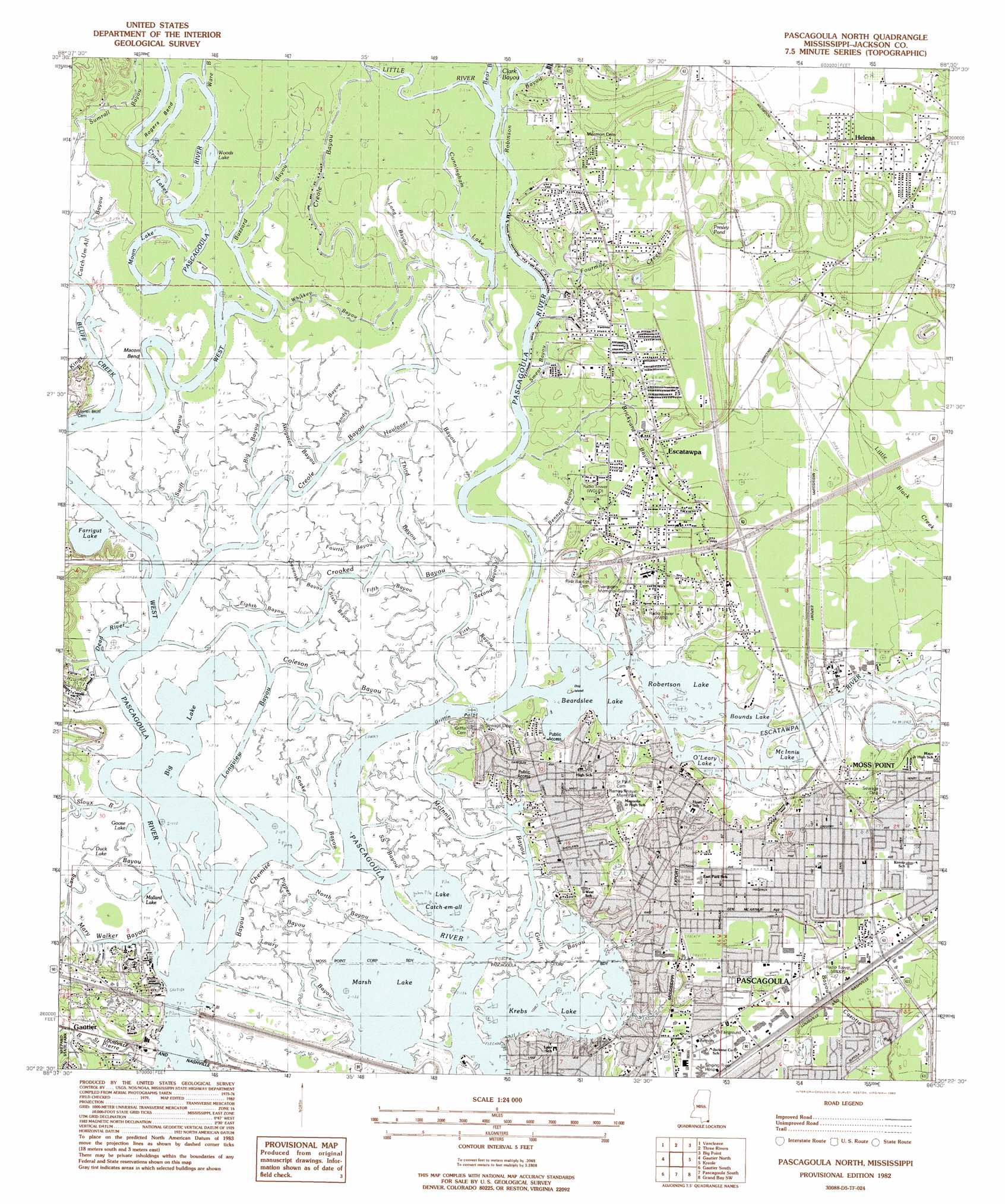
Pascagoula North Topo Map Mississippi
To zoom in, hover over the map of Pascagoula North
USGS Topo Quad 30088d5 - 1:24,000 scale
| Topo Map Name: | Pascagoula North |
| USGS Topo Quad ID: | 30088d5 |
| Print Size: | ca. 21 1/4" wide x 27" high |
| Southeast Coordinates: | 30.375° N latitude / 88.5° W longitude |
| Map Center Coordinates: | 30.4375° N latitude / 88.5625° W longitude |
| U.S. State: | MS |
| Filename: | o30088d5.jpg |
| Download Map JPG Image: | Pascagoula North topo map 1:24,000 scale |
| Map Type: | Topographic |
| Topo Series: | 7.5´ |
| Map Scale: | 1:24,000 |
| Source of Map Images: | United States Geological Survey (USGS) |
| Alternate Map Versions: |
Pascagoula North MS 1982, updated 1983 Download PDF Buy paper map Pascagoula North MS 2012 Download PDF Buy paper map Pascagoula North MS 2015 Download PDF Buy paper map |
1:24,000 Topo Quads surrounding Pascagoula North
Vestry |
Easen Hill |
Harleston |
Hurley |
Tanner Williams |
Latimer |
Vancleave |
Three Rivers |
Big Point |
Saint Elmo |
Ocean Springs |
Gautier North |
Pascagoula North |
Kreole |
Grand Bay |
Deer Island |
Gautier South |
Pascagoula South |
Grand Bay Sw |
Isle Aux Herbes |
Dog Keys Pass |
Horn Island West |
Horn Island East |
Petit Bois Island |
Petit Bois Pass |
> Back to 30088a1 at 1:100,000 scale
> Back to 30088a1 at 1:250,000 scale
> Back to U.S. Topo Maps home
Pascagoula North topo map: Gazetteer
Pascagoula North: Bends
Macon Bend elevation 0m 0′Rogers Bend elevation 0m 0′
Pascagoula North: Capes
Griffin Point elevation 0m 0′Pascagoula North: Cliffs
Martins Bluff elevation 1m 3′Pascagoula North: Crossings
Elders Ferry (historical) elevation 0m 0′Interchange 68 elevation 8m 26′
Interchange 69 elevation 5m 16′
Randall Ferry (historical) elevation 0m 0′
Pascagoula North: Guts
Bayou Chemise elevation 0m 0′Coleson Bayou elevation 1m 3′
Crooked Bayou elevation 1m 3′
Dead River elevation 0m 0′
Fifth Bayou elevation 1m 3′
Fourth Bayou elevation 1m 3′
Gurlie Bayou elevation 1m 3′
Lang Bayou elevation 1m 3′
Longview Bayou elevation 1m 3′
Lowry Bayou elevation 1m 3′
McInnis Bayou elevation 1m 3′
North Bayou elevation 1m 3′
Pigpen Bayou elevation 1m 3′
Sandy Bayou elevation 1m 3′
Snake Bayou elevation 1m 3′
SS Bayou elevation 1m 3′
Swift Bayou elevation 1m 3′
Third Bayou elevation 1m 3′
Pascagoula North: Islands
Dog Island elevation 0m 0′Lowry Island elevation 1m 3′
Pascagoula North: Lakes
Beardslee Lake elevation 0m 0′Big Lake elevation 0m 0′
Bounds Lake elevation 0m 0′
Crane Lakes elevation 0m 0′
Cunningham Lake elevation 1m 3′
Duck Lake elevation 1m 3′
Farrigut Lake elevation 0m 0′
Goose Lake elevation 1m 3′
Krebs Lake elevation 0m 0′
Lake Catch-em-all elevation 0m 0′
Mallard Lake elevation 1m 3′
Marsh Lake elevation 0m 0′
McInnis Lake elevation 0m 0′
Moon Lake elevation 1m 3′
O'Leary Lake elevation 0m 0′
Presley Pond elevation 2m 6′
Robertson Lake elevation 0m 0′
Woods Lake elevation 1m 3′
Pascagoula North: Parks
Bellview Park elevation 2m 6′Frederick Street Park elevation 6m 19′
Jackson County Ski Area elevation 1m 3′
Moss Point Recreation Center elevation 2m 6′
Rames Khayat Memorial Park elevation 2m 6′
Sue Ellen Street Park elevation 5m 16′
Pascagoula North: Populated Places
Escatawpa elevation 4m 13′Ford elevation 2m 6′
Gautier elevation 3m 9′
Moss Point elevation 5m 16′
Sawmill Pointe elevation 5m 16′
Pascagoula North: Streams
Alligator Bayou elevation 1m 3′Bear Bayou elevation 0m 0′
Big Bayou elevation 1m 3′
Bluff Creek elevation 0m 0′
Brickyard Bayou elevation 0m 0′
Buzzard Bayou elevation 0m 0′
Clark Bayou elevation 0m 0′
Creole Bayou elevation 0m 0′
Dutch Bayou elevation 0m 0′
Eighth Bayou elevation 0m 0′
Escatawpa River elevation 0m 0′
First Bayou elevation 0m 0′
Haulover Bayou elevation 1m 3′
Little River elevation 4m 13′
Long Bayou elevation 2m 6′
Mary Walker Bayou elevation 0m 0′
Robinson Bayou elevation 1m 3′
Second Bayou elevation 1m 3′
Seventh Bayou elevation 1m 3′
Sioux Bayou elevation 0m 0′
Sixth Bayou elevation 1m 3′
Smear Bayou elevation 1m 3′
Ware Bayou elevation 1m 3′
Pascagoula North digital topo map on disk
Buy this Pascagoula North topo map showing relief, roads, GPS coordinates and other geographical features, as a high-resolution digital map file on DVD:
Gulf Coast (LA, MS, AL, FL) & Southwestern Georgia
Buy digital topo maps: Gulf Coast (LA, MS, AL, FL) & Southwestern Georgia
 & Southwestern Georgia map DVD")