Sorrento Topo Map Louisiana
To zoom in, hover over the map of Sorrento
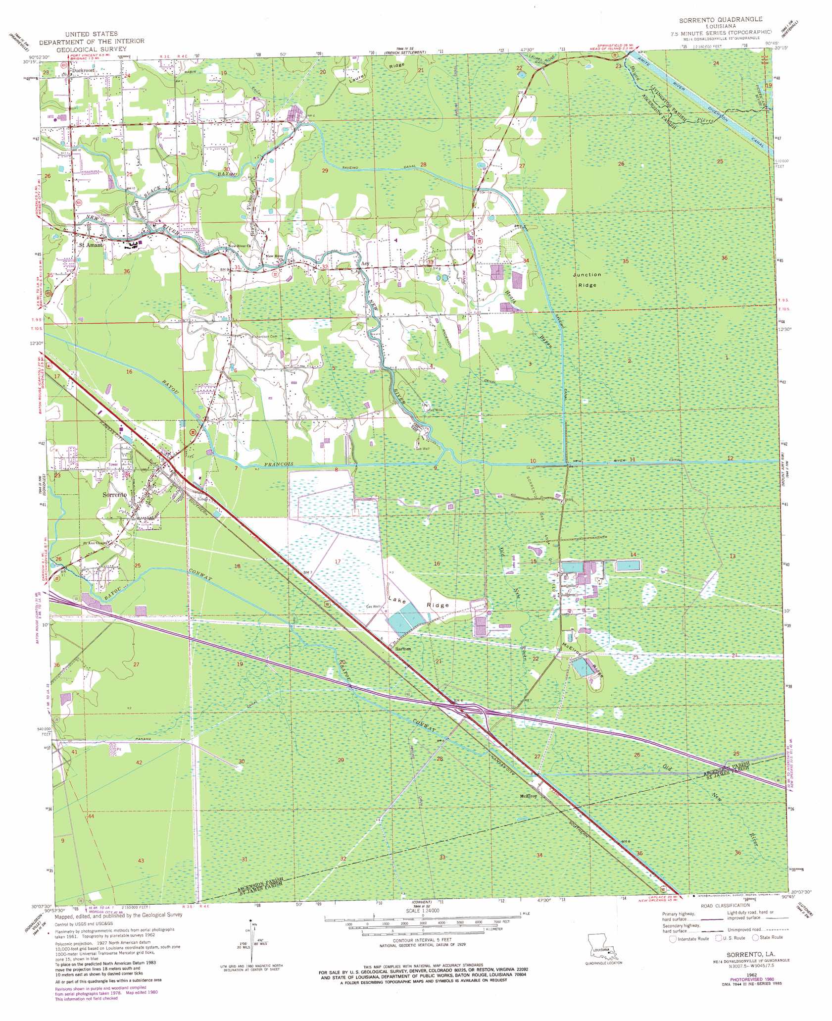
USGS Topo Quad 30090b7 - 1:24,000 scale
| Topo Map Name: | Sorrento |
| USGS Topo Quad ID: | 30090b7 |
| Print Size: | ca. 21 1/4" wide x 27" high |
| Southeast Coordinates: | 30.125° N latitude / 90.75° W longitude |
| Map Center Coordinates: | 30.1875° N latitude / 90.8125° W longitude |
| U.S. State: | LA |
| Filename: | o30090b7.jpg |
| Download Map JPG Image: | Sorrento topo map 1:24,000 scale |
| Map Type: | Topographic |
| Topo Series: | 7.5´ |
| Map Scale: | 1:24,000 |
| Source of Map Images: | United States Geological Survey (USGS) |
| Alternate Map Versions: |
Sorrento LA 1962, updated 1963 Download PDF Buy paper map Sorrento LA 1962, updated 1969 Download PDF Buy paper map Sorrento LA 1962, updated 1981 Download PDF Buy paper map Sorrento LA 1962, updated 1981 Download PDF Buy paper map Sorrento LA 2012 Download PDF Buy paper map Sorrento LA 2015 Download PDF Buy paper map |
1:24,000 Topo Quads surrounding Sorrento
Baton Rouge East |
Denham Springs |
Walker |
Frost |
Springfield |
Saint Gabriel |
Prairieville |
French Settlement |
Whitehall |
Killian |
Carville |
Gonzales |
Sorrento |
Mount Airy Nw |
Mount Airy Ne |
Belle Rose |
Donaldsonville |
Convent |
Lutcher |
Reserve |
Napoleonville |
Madewood |
Lagan |
Lower Vacherie |
Lac Des Allemands |
> Back to 30090a1 at 1:100,000 scale
> Back to 30090a1 at 1:250,000 scale
> Back to U.S. Topo Maps home
Sorrento topo map: Gazetteer
Sorrento: Canals
Amite River Diversion Canal elevation 0m 0′Anderson Canal elevation 1m 3′
Babin Canal elevation 1m 3′
New River Canal elevation 2m 6′
Saveiro Canal elevation 3m 9′
Sorrento: Crossings
Interchange 187 elevation 1m 3′Sorrento: Oilfields
Sorrento Gas and Oil Field elevation 0m 0′Sorrento: Populated Places
Acy elevation 2m 6′Barmen elevation 1m 3′
Duckroost elevation 2m 6′
McElroy elevation 1m 3′
Saint Amant elevation 2m 6′
Sorrento elevation 2m 6′
Sorrento: Post Offices
Saint Amant Post Office elevation 3m 9′Sorrento: Ridges
Junction Ridge elevation 1m 3′Lake Ridge elevation 1m 3′
McElroy Ridge elevation 0m 0′
Sorrento: Streams
Bayou Conway elevation 0m 0′Bayou Francois elevation 1m 3′
Bayou Pierre elevation 0m 0′
Bayou Vicknair elevation 1m 3′
Black Bayou elevation 0m 0′
Duckroost Bayou elevation 2m 6′
Heath Bayou elevation 0m 0′
New River elevation 0m 0′
Pierre Bayou elevation 0m 0′
Sorrento digital topo map on disk
Buy this Sorrento topo map showing relief, roads, GPS coordinates and other geographical features, as a high-resolution digital map file on DVD: