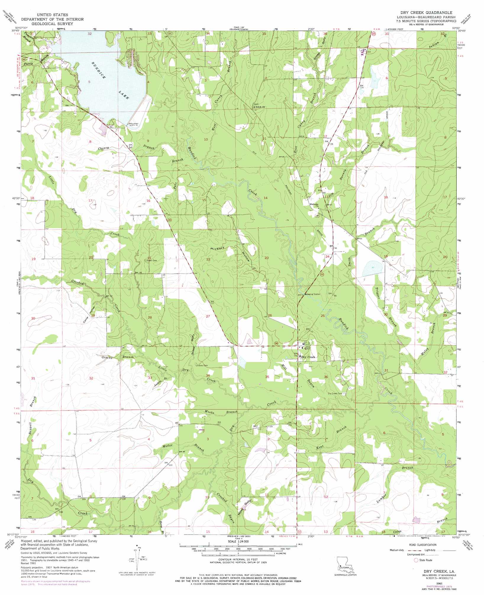
Dry Creek Topo Map Louisiana
To zoom in, hover over the map of Dry Creek
USGS Topo Quad 30093f1 - 1:24,000 scale
| Topo Map Name: | Dry Creek |
| USGS Topo Quad ID: | 30093f1 |
| Print Size: | ca. 21 1/4" wide x 27" high |
| Southeast Coordinates: | 30.625° N latitude / 93° W longitude |
| Map Center Coordinates: | 30.6875° N latitude / 93.0625° W longitude |
| U.S. State: | LA |
| Filename: | o30093f1.jpg |
| Download Map JPG Image: | Dry Creek topo map 1:24,000 scale |
| Map Type: | Topographic |
| Topo Series: | 7.5´ |
| Map Scale: | 1:24,000 |
| Source of Map Images: | United States Geological Survey (USGS) |
| Alternate Map Versions: |
Dry Creek LA 1950, updated 1952 Download PDF Buy paper map Dry Creek LA 1961, updated 1963 Download PDF Buy paper map Dry Creek LA 1961, updated 1976 Download PDF Buy paper map Dry Creek LA 2012 Download PDF Buy paper map Dry Creek LA 2015 Download PDF Buy paper map |
1:24,000 Topo Quads surrounding Dry Creek
Rose Pine |
Hurricane Branch |
Sugrue |
Pitkin |
Steep Gully |
De Ridder |
Boneset Creek |
Sugartown |
Grant |
Elizabeth |
Mach Branch |
Redhead Branch |
Dry Creek |
Mittie |
Pine Chapel |
Kernan |
Longville |
Reeves |
Le Blanc |
Oberlin |
Gordon |
Gaytine |
Topsy |
Indian Village |
Kinder |
> Back to 30093e1 at 1:100,000 scale
> Back to 30092a1 at 1:250,000 scale
> Back to U.S. Topo Maps home
Dry Creek topo map: Gazetteer
Dry Creek: Airports
BT and KH Ranch Airport elevation 33m 108′Dry Creek: Dams
Bundicks Creek Dam elevation 28m 91′Louisiana Noname 103 Dam elevation 39m 127′
Louisiana Noname 77 Dam elevation 24m 78′
Dry Creek: Populated Places
Bundick (historical) elevation 33m 108′Dry Creek elevation 30m 98′
Dry Creek: Post Offices
Dry Creek Post Office elevation 32m 104′Dry Creek: Reservoirs
Bundick Lake elevation 28m 91′Dry Creek: Streams
Anders Branch elevation 25m 82′Baygall Branch elevation 32m 104′
Cherry Branch elevation 22m 72′
Crooked Branch elevation 24m 78′
Crooked Creek elevation 27m 88′
Dry Branch elevation 28m 91′
Dry Creek elevation 16m 52′
East Caney Branch elevation 23m 75′
Farris Branch elevation 29m 95′
Greens Branch elevation 28m 91′
Horse Branch elevation 27m 88′
Jim Burney Branch elevation 19m 62′
Kent Branch elevation 16m 52′
Little Dry Creek elevation 20m 65′
Lumber Branch elevation 18m 59′
Mill Bayou elevation 17m 55′
Miller Branch elevation 22m 72′
Muley Branch elevation 17m 55′
Pate Branch elevation 23m 75′
Pumpkin Branch elevation 29m 95′
Sheep Gully elevation 30m 98′
Smith Branch elevation 19m 62′
Trigger Branch elevation 18m 59′
Weeks Branch elevation 23m 75′
West Caney Branch elevation 21m 68′
Dry Creek: Valleys
Camp Hollow elevation 31m 101′Hickory Hollow elevation 24m 78′
Miller Gully elevation 26m 85′
Steep Gully elevation 26m 85′
Dry Creek digital topo map on disk
Buy this Dry Creek topo map showing relief, roads, GPS coordinates and other geographical features, as a high-resolution digital map file on DVD: