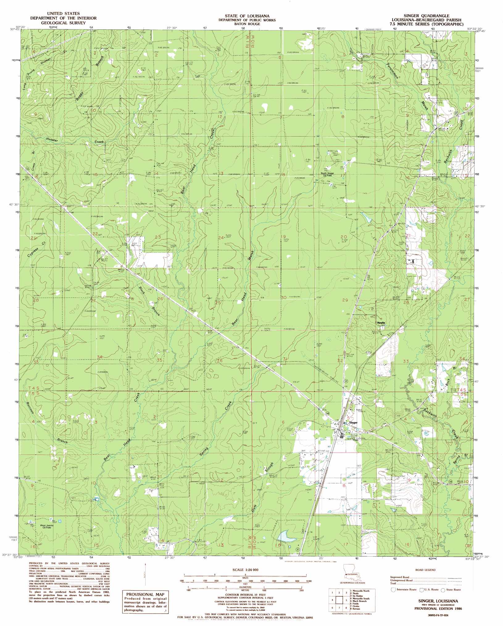
Singer Topo Map Louisiana
To zoom in, hover over the map of Singer
USGS Topo Quad 30093f4 - 1:24,000 scale
| Topo Map Name: | Singer |
| USGS Topo Quad ID: | 30093f4 |
| Print Size: | ca. 21 1/4" wide x 27" high |
| Southeast Coordinates: | 30.625° N latitude / 93.375° W longitude |
| Map Center Coordinates: | 30.6875° N latitude / 93.4375° W longitude |
| U.S. State: | LA |
| Filename: | o30093f4.jpg |
| Download Map JPG Image: | Singer topo map 1:24,000 scale |
| Map Type: | Topographic |
| Topo Series: | 7.5´ |
| Map Scale: | 1:24,000 |
| Source of Map Images: | United States Geological Survey (USGS) |
| Alternate Map Versions: |
Singer LA 1986, updated 1986 Download PDF Buy paper map Singer LA 2012 Download PDF Buy paper map Singer LA 2015 Download PDF Buy paper map |
1:24,000 Topo Quads surrounding Singer
Shankleville |
Evans |
Knight |
Rose Pine |
Hurricane Branch |
Newton East |
Merryville North |
Neale |
De Ridder |
Boneset Creek |
Bon Wier |
Merryville South |
Singer |
Mach Branch |
Redhead Branch |
Bancroft |
Fields |
Oretta |
Kernan |
Longville |
Shoats Creek |
Clark Hollow |
De Quincy |
Gordon |
Gaytine |
> Back to 30093e1 at 1:100,000 scale
> Back to 30092a1 at 1:250,000 scale
> Back to U.S. Topo Maps home
Singer topo map: Gazetteer
Singer: Dams
Louisiana Noname 74 Dam elevation 46m 150′Singer: Oilfields
Black Branch Oil Field elevation 49m 160′North Singer Oil Field elevation 49m 160′
West Juanita Oil Field elevation 44m 144′
Singer: Populated Places
Newlin elevation 44m 144′Singer elevation 45m 147′
Singer: Post Offices
Singer Post Office elevation 45m 147′Singer: Streams
Bear Head Marsh elevation 37m 121′Black Branch elevation 38m 124′
Boggy Branch elevation 34m 111′
Buck Branch elevation 31m 101′
Cowpen Creek elevation 35m 114′
Crazy Branch elevation 33m 108′
Persimmon Marsh elevation 37m 121′
Raccoon Branch elevation 33m 108′
Spring Branch elevation 28m 91′
Spring Creek elevation 33m 108′
Wildcat Branch elevation 35m 114′
Singer digital topo map on disk
Buy this Singer topo map showing relief, roads, GPS coordinates and other geographical features, as a high-resolution digital map file on DVD: