North Franklin Mountain Topo Map Texas
To zoom in, hover over the map of North Franklin Mountain
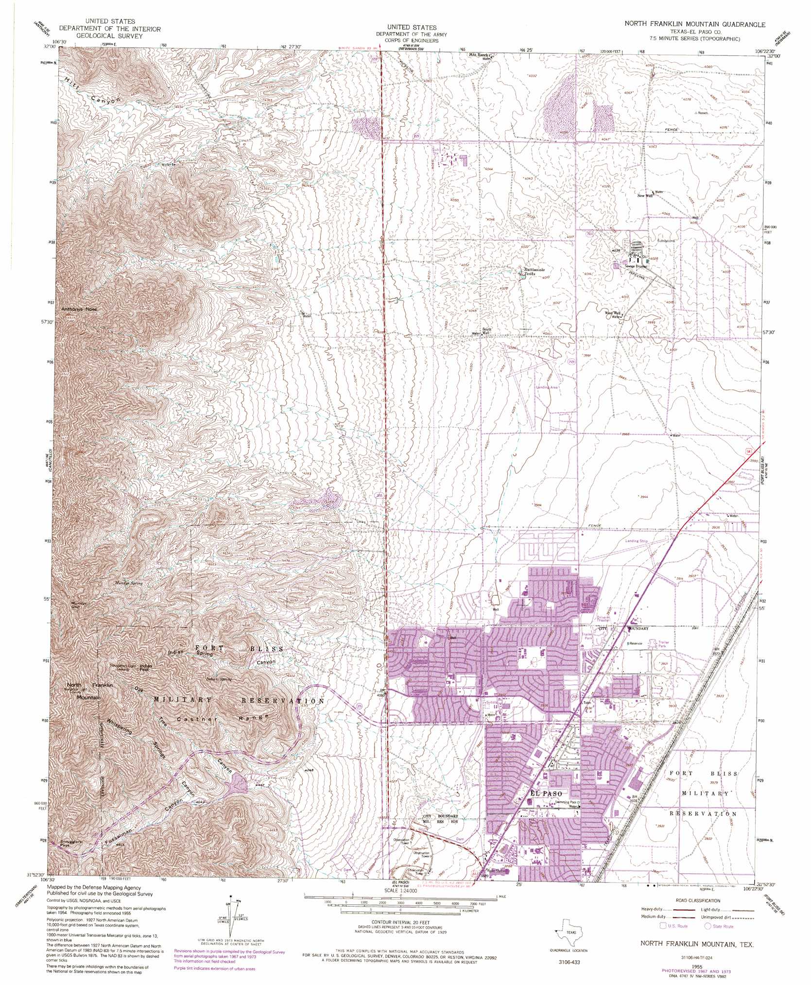
USGS Topo Quad 31106h4 - 1:24,000 scale
| Topo Map Name: | North Franklin Mountain |
| USGS Topo Quad ID: | 31106h4 |
| Print Size: | ca. 21 1/4" wide x 27" high |
| Southeast Coordinates: | 31.875° N latitude / 106.375° W longitude |
| Map Center Coordinates: | 31.9375° N latitude / 106.4375° W longitude |
| U.S. State: | TX |
| Filename: | o31106h4.jpg |
| Download Map JPG Image: | North Franklin Mountain topo map 1:24,000 scale |
| Map Type: | Topographic |
| Topo Series: | 7.5´ |
| Map Scale: | 1:24,000 |
| Source of Map Images: | United States Geological Survey (USGS) |
| Alternate Map Versions: |
North Franklin Mountain TX 1955, updated 1959 Download PDF Buy paper map North Franklin Mountain TX 1955, updated 1967 Download PDF Buy paper map North Franklin Mountain TX 1955, updated 1974 Download PDF Buy paper map North Franklin Mountain TX 1955, updated 1991 Download PDF Buy paper map North Franklin Mountain TX 1995, updated 1995 Download PDF Buy paper map North Franklin Mountain TX 2010 Download PDF Buy paper map North Franklin Mountain TX 2012 Download PDF Buy paper map North Franklin Mountain TX 2016 Download PDF Buy paper map |
1:24,000 Topo Quads surrounding North Franklin Mountain
San Miguel |
Bishop Cap |
Newman Nw |
Newman Ne |
Desert |
La Mesa |
Anthony |
Newman Sw |
Newman |
Desert Sw |
La Union |
Canutillo |
North Franklin Mountain |
Fort Bliss Ne |
Nations East Well |
Strauss |
Smeltertown |
El Paso |
Fort Bliss Se |
Nations South Well |
Ysleta Nw |
Ysleta |
Clint Nw |
> Back to 31106e1 at 1:100,000 scale
> Back to 31106a1 at 1:250,000 scale
> Back to U.S. Topo Maps home
North Franklin Mountain topo map: Gazetteer
North Franklin Mountain: Dams
El Paso Electric Company Lake Dam elevation 1235m 4051′Fusselman Dam elevation 1362m 4468′
Range Dam elevation 1185m 3887′
North Franklin Mountain: Gaps
Mundys Gap elevation 1800m 5905′Smugglers Pass elevation 1653m 5423′
North Franklin Mountain: Parks
Andress High School Stadium elevation 1205m 3953′Arlington Park elevation 1229m 4032′
Civic Leaders Park elevation 1205m 3953′
Cohen Stadium elevation 1223m 4012′
Colonia Verde Park elevation 1201m 3940′
Dolphin Park elevation 1196m 3923′
Milagro Park elevation 1202m 3943′
Recreation Ranch Park elevation 1192m 3910′
Shearman Park elevation 1195m 3920′
Skyline Optimist Youth Park elevation 1200m 3937′
Student Memorial Park elevation 1188m 3897′
Veterans Park elevation 1213m 3979′
North Franklin Mountain: Ranges
Castner Range elevation 1695m 5561′Franklin Mountains elevation 2186m 7171′
North Franklin Mountain: Reservoirs
El Paso Electric Company Lake elevation 1235m 4051′Fusselman Reservoir elevation 1362m 4468′
Range Reservoir elevation 1185m 3887′
Rattlesnake Tanks elevation 1224m 4015′
North Franklin Mountain: Springs
Indian Spring elevation 1456m 4776′Mundys Spring elevation 1518m 4980′
North Franklin Mountain: Summits
Anthonys Nose elevation 2081m 6827′Indian Peak elevation 1985m 6512′
North Franklin Mountain elevation 2186m 7171′
North Franklin Mountain: Trails
Wilderness Park Museum Trail elevation 1296m 4251′North Franklin Mountain: Valleys
Fusselman Canyon elevation 1384m 4540′Hitt Canyon elevation 1352m 4435′
Indian Spring Canyon elevation 1316m 4317′
Oak Tree Canyon elevation 1379m 4524′
Whispering Springs Canyon elevation 1409m 4622′
North Franklin Mountain: Wells
New Well elevation 1235m 4051′South Well elevation 1232m 4041′
West Well elevation 1220m 4002′
North Franklin Mountain digital topo map on disk
Buy this North Franklin Mountain topo map showing relief, roads, GPS coordinates and other geographical features, as a high-resolution digital map file on DVD: