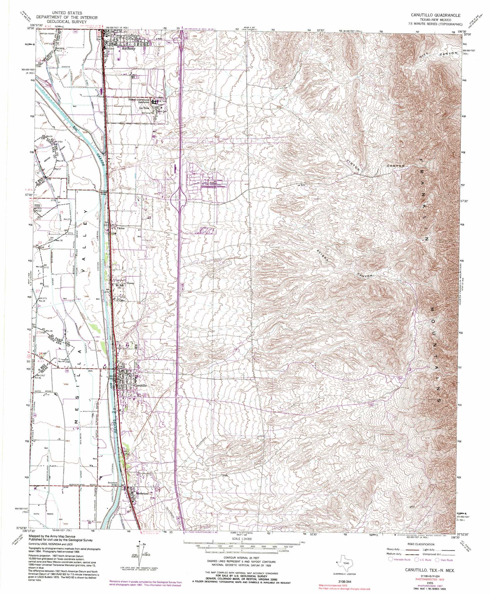
Canutillo Topo Map Texas
To zoom in, hover over the map of Canutillo
USGS Topo Quad 31106h5 - 1:24,000 scale
| Topo Map Name: | Canutillo |
| USGS Topo Quad ID: | 31106h5 |
| Print Size: | ca. 21 1/4" wide x 27" high |
| Southeast Coordinates: | 31.875° N latitude / 106.5° W longitude |
| Map Center Coordinates: | 31.9375° N latitude / 106.5625° W longitude |
| U.S. States: | TX, NM |
| Filename: | o31106h5.jpg |
| Download Map JPG Image: | Canutillo topo map 1:24,000 scale |
| Map Type: | Topographic |
| Topo Series: | 7.5´ |
| Map Scale: | 1:24,000 |
| Source of Map Images: | United States Geological Survey (USGS) |
| Alternate Map Versions: |
Canutillo TX 1955, updated 1962 Download PDF Buy paper map Canutillo TX 1955, updated 1967 Download PDF Buy paper map Canutillo TX 1955, updated 1971 Download PDF Buy paper map Canutillo TX 1955, updated 1991 Download PDF Buy paper map Canutillo TX 1995, updated 1995 Download PDF Buy paper map Canutillo TX 1995, updated 1995 Download PDF Buy paper map Canutillo TX 2010 Download PDF Buy paper map Canutillo TX 2012 Download PDF Buy paper map Canutillo TX 2016 Download PDF Buy paper map |
1:24,000 Topo Quads surrounding Canutillo
Black Mesa |
San Miguel |
Bishop Cap |
Newman Nw |
Newman Ne |
Little Black Mountain |
La Mesa |
Anthony |
Newman Sw |
Newman |
Lanark |
La Union |
Canutillo |
North Franklin Mountain |
Fort Bliss Ne |
Noria |
Strauss |
Smeltertown |
El Paso |
Fort Bliss Se |
Ysleta Nw |
Ysleta |
> Back to 31106e1 at 1:100,000 scale
> Back to 31106a1 at 1:250,000 scale
> Back to U.S. Topo Maps home
Canutillo topo map: Gazetteer
Canutillo: Bridges
Borderland Bridge elevation 1147m 3763′Canutillo: Canals
Anthony Drain elevation 1155m 3789′Borderland Spur elevation 1147m 3763′
East Drain elevation 1157m 3795′
La Union East Lateral elevation 1148m 3766′
Nemexas Drain elevation 1147m 3763′
Three Saints Lateral elevation 1156m 3792′
Vinton Drain elevation 1153m 3782′
Vinton Drain elevation 1152m 3779′
Vinton Lateral elevation 1153m 3782′
Vinton Lateral elevation 1153m 3782′
Vinton River Drain elevation 1151m 3776′
Canutillo: Parks
Franklin Mountains State Natural Area elevation 1829m 6000′Gallegos Park elevation 1149m 3769′
Irnie Ranson Park elevation 1177m 3861′
Canutillo: Populated Places
Anthony elevation 1160m 3805′Borderland elevation 1150m 3772′
Canutillo elevation 1150m 3772′
Green Acres Colonia elevation 1146m 3759′
Hermosa Vista Addition Colonia elevation 1158m 3799′
La Tuna elevation 1184m 3884′
La Union Estates Colonia elevation 1149m 3769′
Mobile Haven Estates Colonia elevation 1214m 3982′
Nuway elevation 1161m 3809′
Nuway Addition Colonia elevation 1156m 3792′
Polkinghorn Addition Colonia elevation 1171m 3841′
Ponderosa Mobile Home Colonia elevation 1149m 3769′
Prado Verde elevation 1147m 3763′
Prado Verde Addition Number 1 Colonia elevation 1147m 3763′
R W Jones Colonia elevation 1168m 3832′
Schuman Estates Colonia elevation 1149m 3769′
Serene Acres Colonia elevation 1149m 3769′
Vinton elevation 1157m 3795′
Vinton Acres Number 1 Colonia elevation 1152m 3779′
Westway elevation 1207m 3959′
Westway Number 1 Colonia elevation 1206m 3956′
Westway Number 2 Colonia elevation 1199m 3933′
Westway Number 3 Colonia elevation 1222m 4009′
Westway Number 4 Colonia elevation 1212m 3976′
Westway Number 6 Colonia elevation 1218m 3996′
Westway Number 7 Colonia elevation 1208m 3963′
Canutillo: Ridges
Cedar Ridge elevation 1149m 3769′Canutillo: Trails
Franklin Mountains State Park Trail Network elevation 1654m 5426′Resler Drive Walk and Bike Trail elevation 1199m 3933′
Tom Mays Unit Trail elevation 1477m 4845′
Canutillo: Valleys
Avispa Canyon elevation 1280m 4199′Vinton Canyon elevation 1276m 4186′
Canutillo: Wells
City 301 Water Well elevation 1153m 3782′NM 4904449 Water Well elevation 1149m 3769′
Q-63 Water Well elevation 1152m 3779′
United States Bureau of Reclamation 49 Water Well elevation 1152m 3779′
United States Bureau of Reclamation 50 Water Well elevation 1149m 3769′
Canutillo digital topo map on disk
Buy this Canutillo topo map showing relief, roads, GPS coordinates and other geographical features, as a high-resolution digital map file on DVD: