Gumm Pond Topo Map Georgia
To zoom in, hover over the map of Gumm Pond
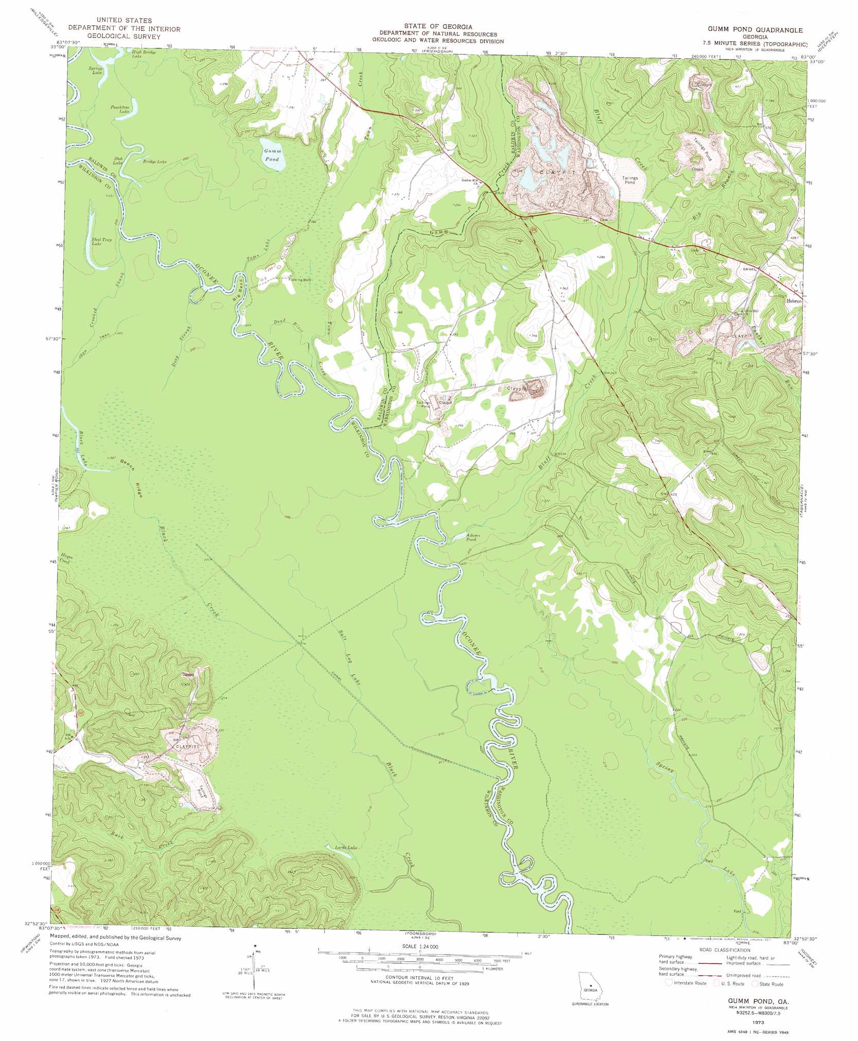
USGS Topo Quad 32083h1 - 1:24,000 scale
| Topo Map Name: | Gumm Pond |
| USGS Topo Quad ID: | 32083h1 |
| Print Size: | ca. 21 1/4" wide x 27" high |
| Southeast Coordinates: | 32.875° N latitude / 83° W longitude |
| Map Center Coordinates: | 32.9375° N latitude / 83.0625° W longitude |
| U.S. State: | GA |
| Filename: | o32083h1.jpg |
| Download Map JPG Image: | Gumm Pond topo map 1:24,000 scale |
| Map Type: | Topographic |
| Topo Series: | 7.5´ |
| Map Scale: | 1:24,000 |
| Source of Map Images: | United States Geological Survey (USGS) |
| Alternate Map Versions: |
Gumm Pond GA 1973, updated 1977 Download PDF Buy paper map Gumm Pond GA 2011 Download PDF Buy paper map Gumm Pond GA 2014 Download PDF Buy paper map |
1:24,000 Topo Quads surrounding Gumm Pond
Lake Sinclair West |
Lake Sinclair East |
Devereux |
Warthen Nw |
Warthen Ne |
Browns Crossing |
Milledgeville |
Friendship |
Deepstep |
Warthen |
Gordon |
Napier Pond |
Gumm Pond |
Tabernacle |
Sandersville |
Massey Hill |
Irwinton |
Toomsboro |
Oconee |
Irwins Crossroads |
Jeffersonville |
Stuckey Boone Lake |
Nicklesville |
Cow Hell Swamp |
Lovett |
> Back to 32083e1 at 1:100,000 scale
> Back to 32082a1 at 1:250,000 scale
> Back to U.S. Topo Maps home
Gumm Pond topo map: Gazetteer
Gumm Pond: Bends
Big Bend elevation 67m 219′Gumm Pond: Lakes
Adams Pond elevation 66m 216′Black Lake elevation 68m 223′
Bridge Lake elevation 71m 232′
Gumm Pond elevation 68m 223′
High Bridge Lake elevation 72m 236′
Lord Lake elevation 64m 209′
Peachtree Lake elevation 71m 232′
Spring Lake elevation 72m 236′
Steel Trap Lake elevation 68m 223′
Stob Lake elevation 68m 223′
Gumm Pond: Ridges
Beech Ridge elevation 68m 223′Gumm Pond: Streams
Big Branch elevation 76m 249′Black Creek elevation 61m 200′
Bluff Creek elevation 65m 213′
Buck Creek elevation 61m 200′
Crooked Shank elevation 67m 219′
Dead River elevation 67m 219′
Deep Slough elevation 67m 219′
Gumm Creek elevation 67m 219′
Hayes Creek elevation 69m 226′
Ramage Branch elevation 70m 229′
Salt Log Lake elevation 63m 206′
Tomas Lake elevation 67m 219′
Town Creek elevation 65m 213′
Gumm Pond digital topo map on disk
Buy this Gumm Pond topo map showing relief, roads, GPS coordinates and other geographical features, as a high-resolution digital map file on DVD:
South Carolina, Western North Carolina & Northeastern Georgia
Buy digital topo maps: South Carolina, Western North Carolina & Northeastern Georgia