Warthen Ne Topo Map Georgia
To zoom in, hover over the map of Warthen Ne
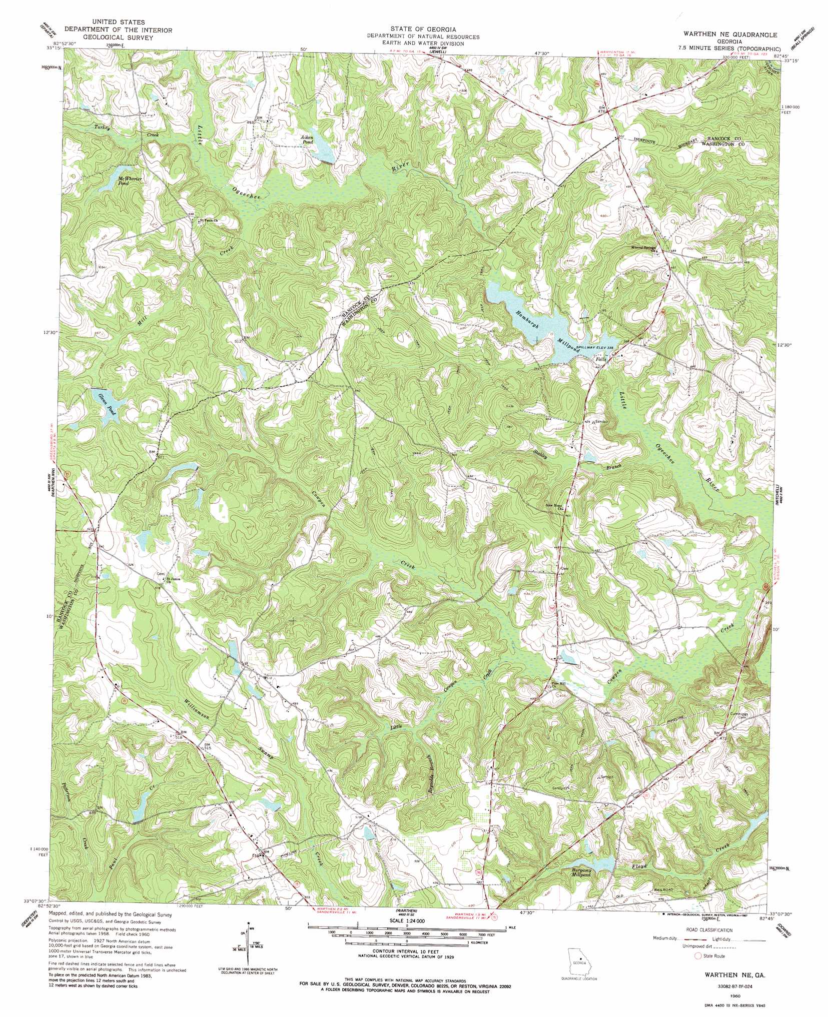
USGS Topo Quad 33082b7 - 1:24,000 scale
| Topo Map Name: | Warthen Ne |
| USGS Topo Quad ID: | 33082b7 |
| Print Size: | ca. 21 1/4" wide x 27" high |
| Southeast Coordinates: | 33.125° N latitude / 82.75° W longitude |
| Map Center Coordinates: | 33.1875° N latitude / 82.8125° W longitude |
| U.S. State: | GA |
| Filename: | o33082b7.jpg |
| Download Map JPG Image: | Warthen Ne topo map 1:24,000 scale |
| Map Type: | Topographic |
| Topo Series: | 7.5´ |
| Map Scale: | 1:24,000 |
| Source of Map Images: | United States Geological Survey (USGS) |
| Alternate Map Versions: |
Warthen NE GA 1960, updated 1961 Download PDF Buy paper map Warthen NE GA 2011 Download PDF Buy paper map Warthen NE GA 2014 Download PDF Buy paper map |
1:24,000 Topo Quads surrounding Warthen Ne
White Plains |
Sparta Nw |
Sparta Ne |
Warrenton |
Thomson West |
Shoulderbone |
Sparta |
Jewell |
Beall Springs |
Bastonville |
Devereux |
Warthen Nw |
Warthen Ne |
Mitchell |
Gibson |
Friendship |
Deepstep |
Warthen |
Downs |
Grange |
Gumm Pond |
Tabernacle |
Sandersville |
Riddleville |
Davisboro |
> Back to 33082a1 at 1:100,000 scale
> Back to 33082a1 at 1:250,000 scale
> Back to U.S. Topo Maps home
Warthen Ne topo map: Gazetteer
Warthen Ne: Dams
Adams Pond North Dam elevation 127m 416′Adams Pond South Dam elevation 138m 452′
Aiken Pond Dam elevation 122m 400′
Burgamy Millpond Dam elevation 118m 387′
Glenn Pond Dam elevation 139m 456′
Hamburg Mill Pond Dam elevation 103m 337′
Ralph Walker Lake Dam elevation 117m 383′
Warthen Ne: Parks
Hamburg State Park elevation 103m 337′Warthen Ne: Populated Places
Eureka (historical) elevation 155m 508′Lindsey (historical) elevation 143m 469′
Warthen Ne: Reservoirs
Adams Pond North elevation 127m 416′Adams Pond South elevation 138m 452′
Aiken Pond elevation 122m 400′
Burgamy Millpond elevation 118m 387′
Glenn Pond elevation 139m 456′
Hamburg Mill Pond elevation 103m 337′
Hamburg Millpond elevation 103m 337′
McWhorter Pond elevation 128m 419′
Ralph Walker Lake elevation 117m 383′
Warthen Ne: Streams
Little Cowpen Creek elevation 102m 334′Meek Branch elevation 113m 370′
Mill Creek elevation 109m 357′
Patterson Creek elevation 105m 344′
Reynolds Branch elevation 112m 367′
Rocky Branch elevation 103m 337′
Stabley Branch elevation 92m 301′
Turkey Creek elevation 112m 367′
Warthen Ne digital topo map on disk
Buy this Warthen Ne topo map showing relief, roads, GPS coordinates and other geographical features, as a high-resolution digital map file on DVD:
South Carolina, Western North Carolina & Northeastern Georgia
Buy digital topo maps: South Carolina, Western North Carolina & Northeastern Georgia