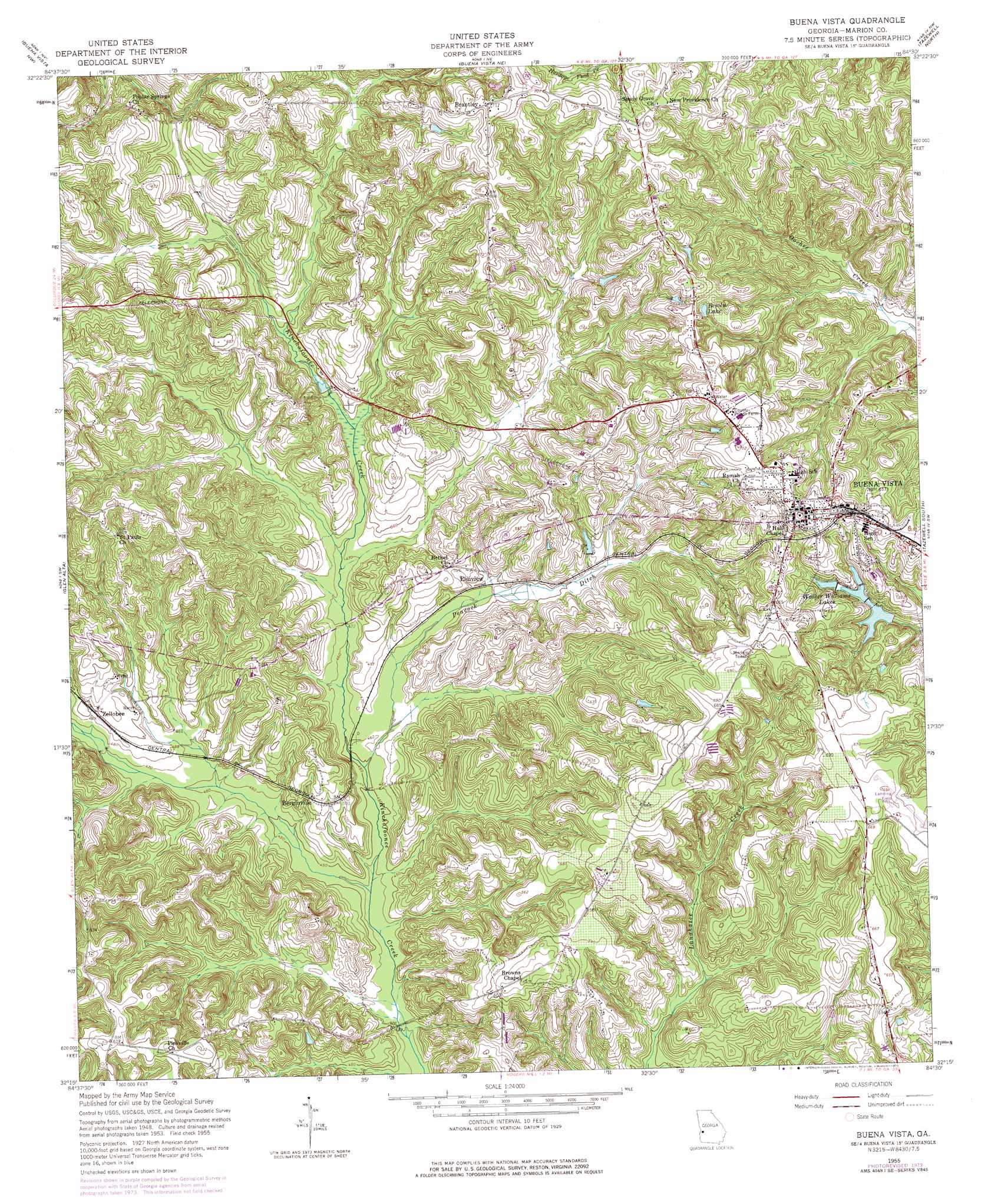
Buena Vista Topo Map Georgia
To zoom in, hover over the map of Buena Vista
USGS Topo Quad 32084c5 - 1:24,000 scale
| Topo Map Name: | Buena Vista |
| USGS Topo Quad ID: | 32084c5 |
| Print Size: | ca. 21 1/4" wide x 27" high |
| Southeast Coordinates: | 32.25° N latitude / 84.5° W longitude |
| Map Center Coordinates: | 32.3125° N latitude / 84.5625° W longitude |
| U.S. State: | GA |
| Filename: | o32084c5.jpg |
| Download Map JPG Image: | Buena Vista topo map 1:24,000 scale |
| Map Type: | Topographic |
| Topo Series: | 7.5´ |
| Map Scale: | 1:24,000 |
| Source of Map Images: | United States Geological Survey (USGS) |
| Alternate Map Versions: |
Buena Vista GA 1950, updated 1953 Download PDF Buy paper map Buena Vista GA 1955, updated 1959 Download PDF Buy paper map Buena Vista GA 1955, updated 1975 Download PDF Buy paper map Buena Vista GA 2011 Download PDF Buy paper map Buena Vista GA 2014 Download PDF Buy paper map |
1:24,000 Topo Quads surrounding Buena Vista
Midland |
Upatoi |
Geneva |
Junction City |
Butler West |
Ochillee |
Buena Vista Nw |
Buena Vista Ne |
Tazewell North |
Rupert |
Cusseta |
Glen Alta |
Buena Vista |
Tazewell South |
Ellaville North |
Louvale |
Brooklyn |
Church Hill |
Draneville |
Ellaville South |
Lumpkin |
Richland |
Preston |
Plains |
Lake Collins |
> Back to 32084a1 at 1:100,000 scale
> Back to 32084a1 at 1:250,000 scale
> Back to U.S. Topo Maps home
Buena Vista topo map: Gazetteer
Buena Vista: Airports
Marion County Airport elevation 205m 672′Marion Hospital Heliport elevation 209m 685′
Buena Vista: Dams
Lower Walker Williams Lake Dam elevation 171m 561′Buena Vista: Populated Places
Berginville elevation 158m 518′Brantley elevation 218m 715′
Buena Vista elevation 210m 688′
Elmview elevation 151m 495′
Pineville elevation 191m 626′
Zellobee elevation 156m 511′
Buena Vista: Reservoirs
Bebolu Lake elevation 184m 603′Lower Walker Williams Lake elevation 171m 561′
Walker Williams Lakes elevation 172m 564′
Buena Vista: Streams
Peacock Ditch elevation 136m 446′Buena Vista digital topo map on disk
Buy this Buena Vista topo map showing relief, roads, GPS coordinates and other geographical features, as a high-resolution digital map file on DVD:
Gulf Coast (LA, MS, AL, FL) & Southwestern Georgia
Buy digital topo maps: Gulf Coast (LA, MS, AL, FL) & Southwestern Georgia
 & Southwestern Georgia map DVD")