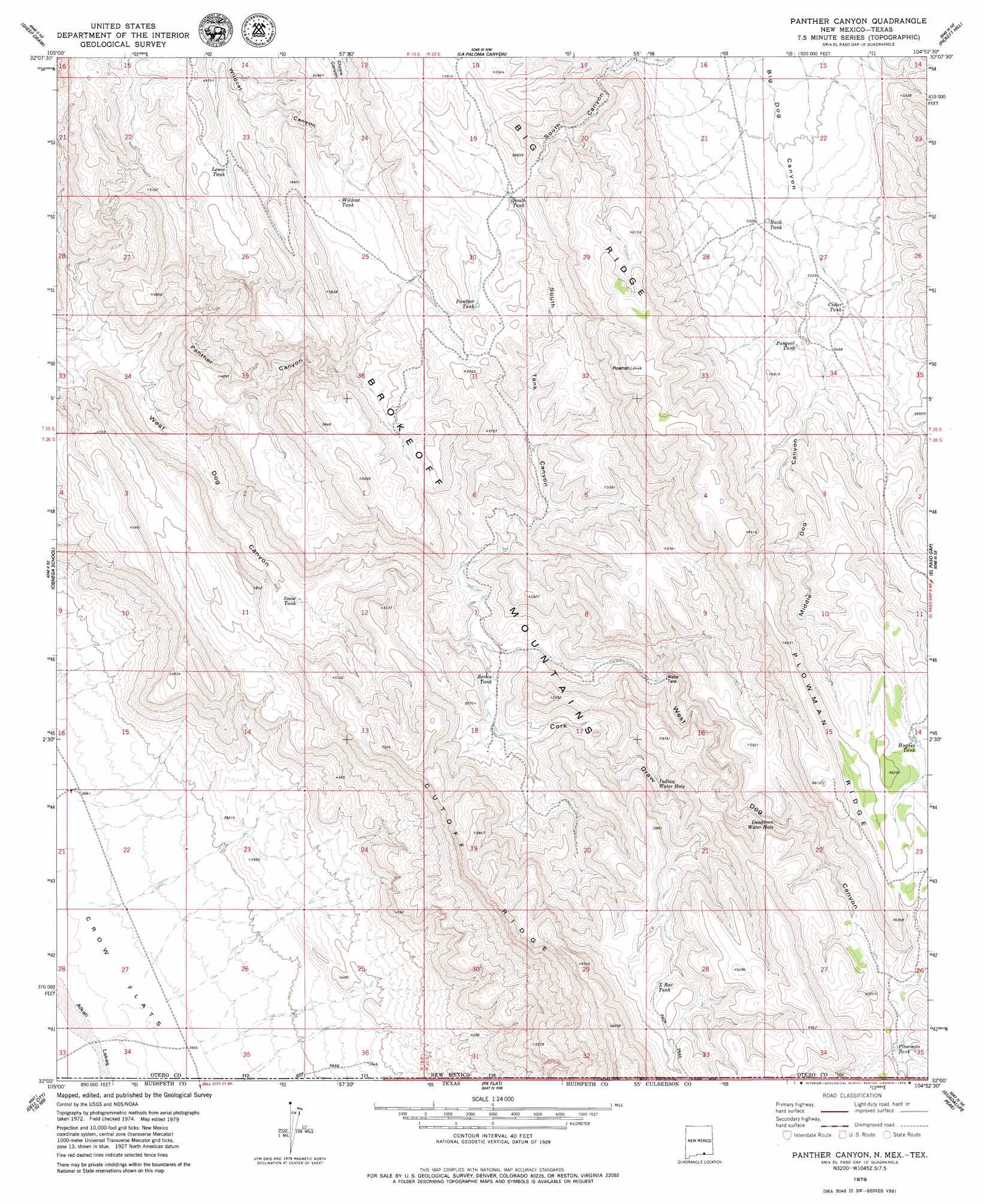
Panther Canyon Topo Map New Mexico
To zoom in, hover over the map of Panther Canyon
USGS Topo Quad 32104a8 - 1:24,000 scale
| Topo Map Name: | Panther Canyon |
| USGS Topo Quad ID: | 32104a8 |
| Print Size: | ca. 21 1/4" wide x 27" high |
| Southeast Coordinates: | 32° N latitude / 104.875° W longitude |
| Map Center Coordinates: | 32.0625° N latitude / 104.9375° W longitude |
| U.S. States: | NM, TX |
| Filename: | o32104a8.jpg |
| Download Map JPG Image: | Panther Canyon topo map 1:24,000 scale |
| Map Type: | Topographic |
| Topo Series: | 7.5´ |
| Map Scale: | 1:24,000 |
| Source of Map Images: | United States Geological Survey (USGS) |
| Alternate Map Versions: |
Panther Canyon NM 2010 Download PDF Buy paper map Panther Canyon NM 2013 Download PDF Buy paper map Panther Canyon NM 2017 Download PDF Buy paper map |
1:24,000 Topo Quads surrounding Panther Canyon
Hackberry Hill |
Gowdy Ranch |
Algerita Canyon |
Ares Peak |
Red Bluff Draw |
Lewis Canyon |
Sheep Draw |
La Paloma Canyon |
Pickett Hill |
Queen |
Culp Draw |
Cienega School |
Panther Canyon |
El Paso Gap |
Gunsight Canyon |
Dell City |
Linda Lake North |
P X Flat |
Guadalupe Peak |
Independence Spring |
Mickey Draw East |
Linda Lake South |
Patterson Hills |
Guadalupe Pass |
Long Point |
> Back to 32104a1 at 1:100,000 scale
> Back to 32104a1 at 1:250,000 scale
> Back to U.S. Topo Maps home
Panther Canyon topo map: Gazetteer
Panther Canyon: Basins
Salt Basin elevation 1128m 3700′Panther Canyon: Parks
Brokeoff Mountains Wilderness Study Area elevation 1774m 5820′Panther Canyon: Reservoirs
Berlin Tank elevation 1473m 4832′Buck Tank elevation 1610m 5282′
Cedar Tank elevation 1636m 5367′
Cork Tanks elevation 1770m 5807′
Deadman Water Hole elevation 1724m 5656′
Hughes Tank elevation 1854m 6082′
Indian Water Hole elevation 1626m 5334′
Lee Magby Tank elevation 1870m 6135′
Lewis Tank elevation 1559m 5114′
Panther Tank elevation 1675m 5495′
Pasqual Tank elevation 1658m 5439′
Plowman Tank elevation 1821m 5974′
Snow Tank elevation 1354m 4442′
South Tank elevation 1707m 5600′
Wildcat Tank elevation 1605m 5265′
Will Magby Tank elevation 1863m 6112′
X Bar Tank elevation 1781m 5843′
Panther Canyon: Ridges
Big Ridge elevation 1881m 6171′Cutoff Ridge elevation 1831m 6007′
Cutoff Ridge elevation 1847m 6059′
Plowman Ridge elevation 1990m 6528′
Panther Canyon: Springs
O Bar U Waterhole elevation 1724m 5656′Panther Canyon: Valleys
Cork Draw elevation 1498m 4914′Cork Draw elevation 1451m 4760′
Middle Dog Canyon elevation 1604m 5262′
Panther Canyon elevation 1266m 4153′
South Canyon elevation 1610m 5282′
South Tank Canyon elevation 1489m 4885′
Panther Canyon: Wells
Den Well elevation 1118m 3667′Panther Canyon digital topo map on disk
Buy this Panther Canyon topo map showing relief, roads, GPS coordinates and other geographical features, as a high-resolution digital map file on DVD: