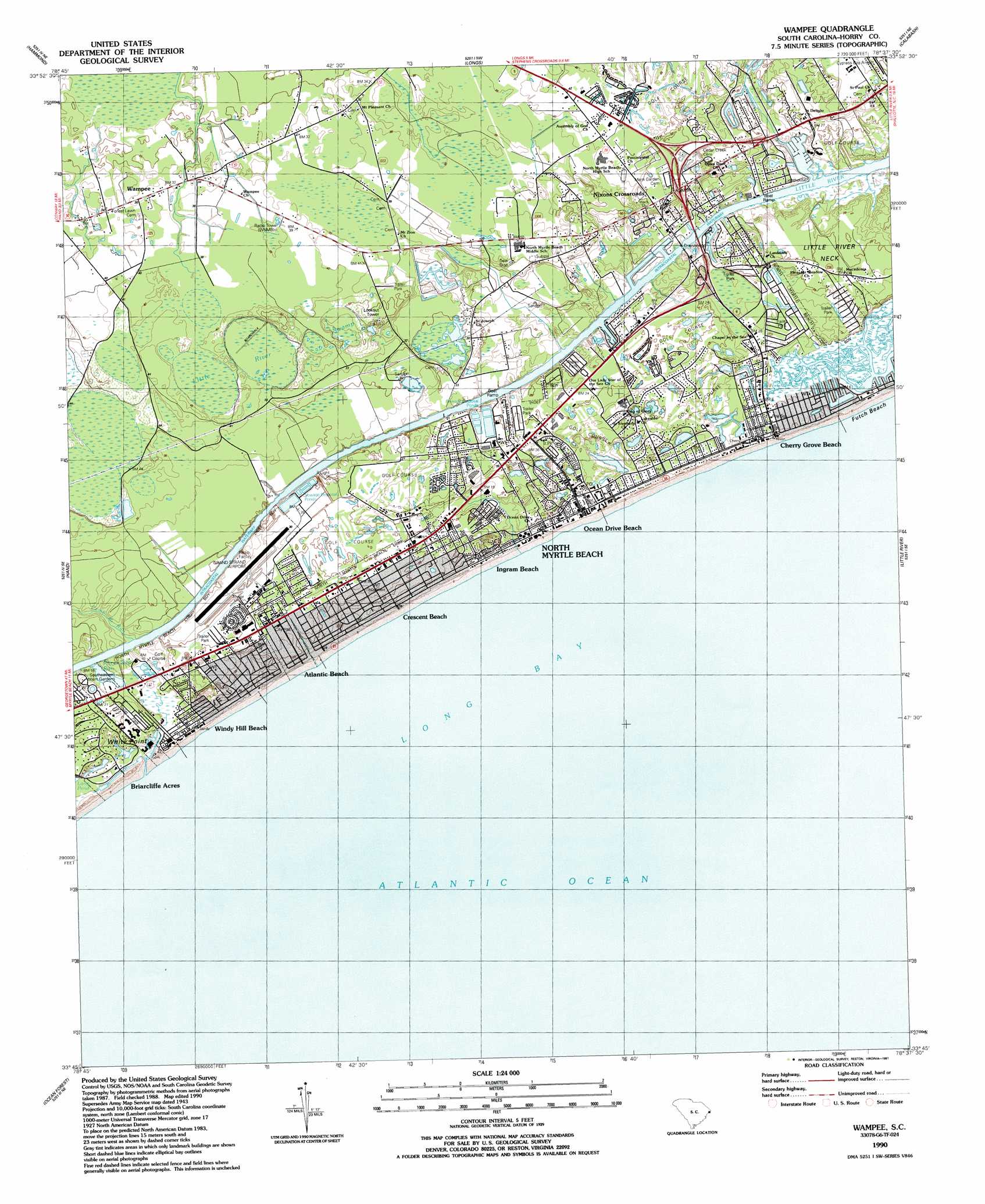
Wampee Topo Map South Carolina
To zoom in, hover over the map of Wampee
USGS Topo Quad 33078g6 - 1:24,000 scale
| Topo Map Name: | Wampee |
| USGS Topo Quad ID: | 33078g6 |
| Print Size: | ca. 21 1/4" wide x 27" high |
| Southeast Coordinates: | 33.75° N latitude / 78.625° W longitude |
| Map Center Coordinates: | 33.8125° N latitude / 78.6875° W longitude |
| U.S. State: | SC |
| Filename: | o33078g6.jpg |
| Download Map JPG Image: | Wampee topo map 1:24,000 scale |
| Map Type: | Topographic |
| Topo Series: | 7.5´ |
| Map Scale: | 1:24,000 |
| Source of Map Images: | United States Geological Survey (USGS) |
| Alternate Map Versions: |
Wampee SC 1943, updated 1947 Download PDF Buy paper map Wampee SC 1990, updated 1991 Download PDF Buy paper map Wampee SC 2011 Download PDF Buy paper map Wampee SC 2014 Download PDF Buy paper map |
1:24,000 Topo Quads surrounding Wampee
Loris |
Goretown |
Pireway |
Freeland |
Exum |
Shell |
Hammond |
Longs |
Calabash |
Shallotte |
Nixonville |
Hand |
Wampee |
Little River |
|
Myrtle Beach |
Ocean Forest |
|||
Surfside Beach |
> Back to 33078e1 at 1:100,000 scale
> Back to 33078a1 at 1:250,000 scale
> Back to U.S. Topo Maps home
Wampee topo map: Gazetteer
Wampee: Airports
Grand Strand Airport elevation 9m 29′Wampee: Bays
Cherry Grove Inlet elevation 1m 3′Wampee: Beaches
Cherry Grove Beach elevation 3m 9′White Point Swash elevation 3m 9′
Windy Hill Beach elevation 1m 3′
Wampee: Capes
White Point elevation 7m 22′Wampee: Dams
Airport Lagoon Dam D-3636 elevation 4m 13′Lewis Pond Dam D-3635 elevation 2m 6′
Wampee: Guts
House Creek elevation 0m 0′Prices Swamp Run elevation 3m 9′
Williams Creek elevation 1m 3′
Wampee: Parks
Central Park elevation 7m 22′McLean Park elevation 4m 13′
Wampee: Populated Places
Atlantic Beach elevation 9m 29′Bay Forest elevation 13m 42′
Belle Park elevation 12m 39′
Briarcliffe Acres elevation 0m 0′
Cedar Creek Village elevation 5m 16′
Cherry Grove Beach elevation 1m 3′
Coquina Harbor elevation 4m 13′
Creekside elevation 5m 16′
Crescent Beach elevation 5m 16′
Forest Lake elevation 7m 22′
Golf View Plantation elevation 12m 39′
Heritage Shores elevation 2m 6′
Hollywood elevation 4m 13′
Ingram Beach elevation 3m 9′
Kingswood elevation 7m 22′
Nixons Crossroads elevation 16m 52′
North Myrtle Beach elevation 2m 6′
Ocean Drive Beach elevation 3m 9′
Old River Estates elevation 6m 19′
Palmetto Shores elevation 4m 13′
Pinewood Acres elevation 7m 22′
Princeton Place elevation 5m 16′
Robbers Roost Villas elevation 8m 26′
The Grove elevation 5m 16′
Tilghman Estates elevation 4m 13′
Timber Ridge elevation 7m 22′
Village at Bay Tree elevation 13m 42′
Wampee elevation 11m 36′
Wampee: Post Offices
Cherry Grove Beach Post Office elevation 2m 6′Coastal Post Office elevation 9m 29′
North Myrtle Beach Post Office elevation 4m 13′
Wampee: Reservoirs
Airport Lagoon elevation 4m 13′Lewis Pond elevation 2m 6′
Wampee: Streams
Camp Branch Run elevation 0m 0′Nixon Creek elevation 1m 3′
Salt Flat Creek elevation 0m 0′
Wampee: Swamps
Little River Swamp elevation 16m 52′Prices Swamp elevation 13m 42′
Wampee digital topo map on disk
Buy this Wampee topo map showing relief, roads, GPS coordinates and other geographical features, as a high-resolution digital map file on DVD:
South Carolina, Western North Carolina & Northeastern Georgia
Buy digital topo maps: South Carolina, Western North Carolina & Northeastern Georgia