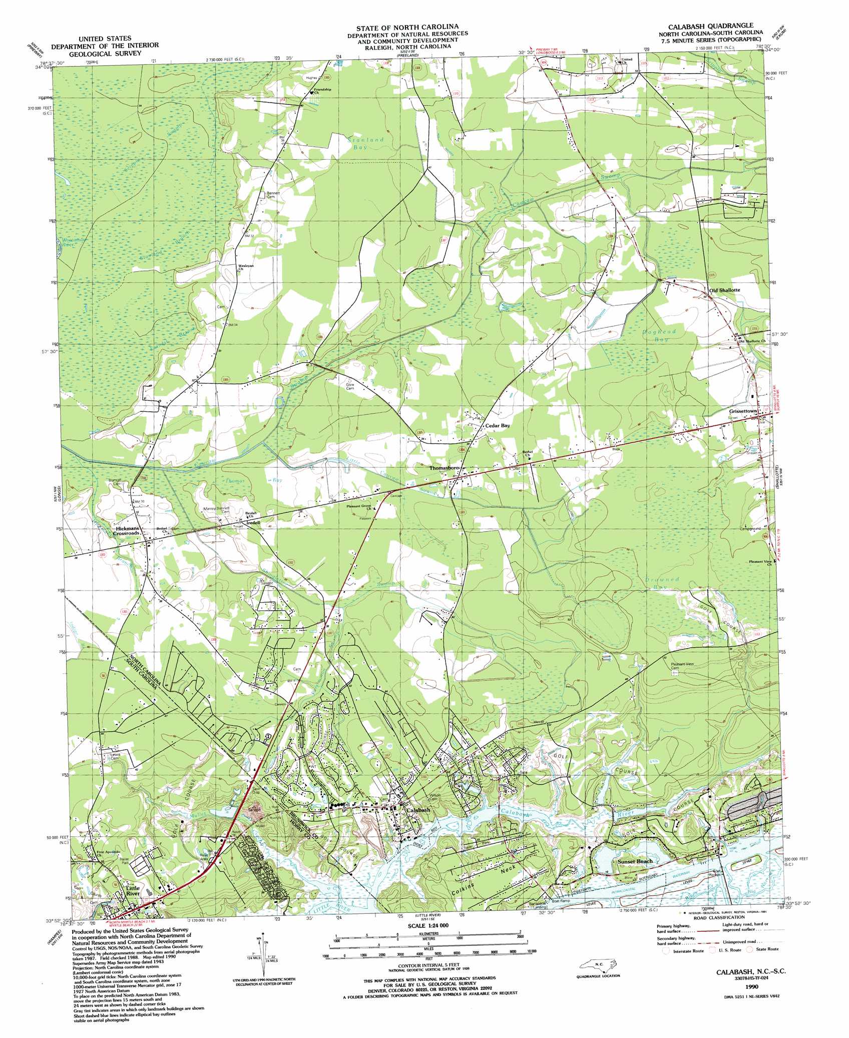
Calabash Topo Map North Carolina
To zoom in, hover over the map of Calabash
USGS Topo Quad 33078h5 - 1:24,000 scale
| Topo Map Name: | Calabash |
| USGS Topo Quad ID: | 33078h5 |
| Print Size: | ca. 21 1/4" wide x 27" high |
| Southeast Coordinates: | 33.875° N latitude / 78.5° W longitude |
| Map Center Coordinates: | 33.9375° N latitude / 78.5625° W longitude |
| U.S. States: | NC, SC |
| Filename: | o33078h5.jpg |
| Download Map JPG Image: | Calabash topo map 1:24,000 scale |
| Map Type: | Topographic |
| Topo Series: | 7.5´ |
| Map Scale: | 1:24,000 |
| Source of Map Images: | United States Geological Survey (USGS) |
| Alternate Map Versions: |
Calabash NC 1953 Download PDF Buy paper map Calabash NC 1990, updated 1991 Download PDF Buy paper map Calabash NC 2011 Download PDF Buy paper map Calabash NC 2013 Download PDF Buy paper map Calabash NC 2016 Download PDF Buy paper map |
1:24,000 Topo Quads surrounding Calabash
Tabor City East |
Nakina |
Old Dock |
Juniper Creek |
Honey Island |
Goretown |
Pireway |
Freeland |
Exum |
Supply |
Hammond |
Longs |
Calabash |
Shallotte |
Holden Beach |
Hand |
Wampee |
Little River |
||
Ocean Forest |
> Back to 33078e1 at 1:100,000 scale
> Back to 33078a1 at 1:250,000 scale
> Back to U.S. Topo Maps home
Calabash topo map: Gazetteer
Calabash: Bays
Milliken Cove elevation 0m 0′Calabash: Bridges
Cawcaw Bridges elevation 7m 22′Iredell Bridge elevation 8m 26′
Shingletree Bridges (historical) elevation 10m 32′
Smith Bridges elevation 8m 26′
Calabash: Capes
Corkins Neck elevation 8m 26′Calabash: Channels
The Big Narrows elevation 0m 0′Calabash: Dams
South Carolina Noname 26020 D-3623 Dam elevation 16m 52′Calabash: Populated Places
Calabash elevation 15m 49′Carolina Shores elevation 14m 45′
Cedar Bay elevation 12m 39′
Grissettown elevation 13m 42′
Hickmans Crossroads elevation 10m 32′
Iredell elevation 10m 32′
Shady Forest elevation 1m 3′
Sunset Beach elevation 0m 0′
Thomasboro elevation 11m 36′
Calabash: Post Offices
Calabash Post Office elevation 15m 49′Sunset Beach Post Office (historical) elevation 0m 0′
Calabash: Reservoirs
Greenbriar Lake elevation 16m 52′Calabash: Streams
Boundary Creek elevation 1m 3′Calabash Creek elevation 1m 3′
Calabash River elevation 1m 3′
Earnest Branch elevation 6m 19′
Hickmans Branch elevation 6m 19′
Little Cawcaw Swamp elevation 8m 26′
Mullet Creek elevation 0m 0′
Persimmon Swamp elevation 10m 32′
Shingletree Swamp elevation 6m 19′
Stanland Branch elevation 6m 19′
Calabash: Swamps
Doghead Bay elevation 17m 55′Drowned Bay elevation 16m 52′
Stanland Bay elevation 13m 42′
Thomas Bay elevation 7m 22′
Calabash digital topo map on disk
Buy this Calabash topo map showing relief, roads, GPS coordinates and other geographical features, as a high-resolution digital map file on DVD:
South Carolina, Western North Carolina & Northeastern Georgia
Buy digital topo maps: South Carolina, Western North Carolina & Northeastern Georgia