Swansea Topo Map South Carolina
To zoom in, hover over the map of Swansea
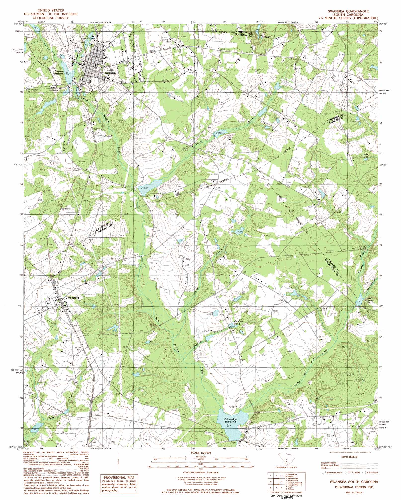
USGS Topo Quad 33081f1 - 1:24,000 scale
| Topo Map Name: | Swansea |
| USGS Topo Quad ID: | 33081f1 |
| Print Size: | ca. 21 1/4" wide x 27" high |
| Southeast Coordinates: | 33.625° N latitude / 81° W longitude |
| Map Center Coordinates: | 33.6875° N latitude / 81.0625° W longitude |
| U.S. State: | SC |
| Filename: | o33081f1.jpg |
| Download Map JPG Image: | Swansea topo map 1:24,000 scale |
| Map Type: | Topographic |
| Topo Series: | 7.5´ |
| Map Scale: | 1:24,000 |
| Source of Map Images: | United States Geological Survey (USGS) |
| Alternate Map Versions: |
Swansea SC 1986, updated 1986 Download PDF Buy paper map Swansea SC 2011 Download PDF Buy paper map Swansea SC 2014 Download PDF Buy paper map |
1:24,000 Topo Quads surrounding Swansea
Barr Lake |
Lexington |
Southwest Columbia |
Fort Jackson South |
Congaree |
Fairview Crossroads |
Pelion East |
Gaston |
Saylors Lake |
Gadsden |
Wagener |
Pond Branch |
Swansea |
Staley Crossroads |
Saint Mathews |
Salley |
Harleys Millpond |
North |
Wolfton |
Orangeburg North |
Springfield |
Norway West |
Norway East |
Cordova |
Orangeburg South |
> Back to 33081e1 at 1:100,000 scale
> Back to 33080a1 at 1:250,000 scale
> Back to U.S. Topo Maps home
Swansea topo map: Gazetteer
Swansea: Bridges
Gissendanner Bridge elevation 76m 249′Swansea: Dams
Granger Pond Dam D-3680 elevation 95m 311′Hoffman Pond Dam D-3681 elevation 96m 314′
Ingletts Pond Dam D-3686 elevation 95m 311′
Layseth Millpond Dam D-2923 elevation 76m 249′
Shannon Pond Dam D-2673 elevation 106m 347′
Shulls Pond Dam D-3685 elevation 81m 265′
South Carolina Noname 32005 D-1710 Dam elevation 111m 364′
South Carolina Noname 32020 D-0982 Dam elevation 102m 334′
South Carolina Noname 32093 D-1008 Dam elevation 92m 301′
South Carolina Noname 32094 D-1009 Dam elevation 102m 334′
South Carolina Noname 38004 D-3684 Dam elevation 69m 226′
South Carolina Noname 38067 D-3683 Dam elevation 78m 255′
Swansea: Lakes
Redmond Pond elevation 90m 295′Swansea: Populated Places
Swansea elevation 108m 354′Woodford elevation 116m 380′
Swansea: Post Offices
Swansea Post Office elevation 101m 331′Swansea: Reservoirs
Brooker Millpond elevation 94m 308′Brookers Mill Pond elevation 102m 334′
Davis Pond elevation 98m 321′
Etheredge Millpond elevation 69m 226′
Fridays Pond elevation 78m 255′
Gardner Pond elevation 84m 275′
Gunter Pond elevation 111m 364′
Knotts Pond elevation 87m 285′
Layseth Millpond elevation 77m 252′
Loyseth Millpond elevation 76m 249′
Midway Millpond elevation 72m 236′
Railroad Pond elevation 101m 331′
Shannon Pond elevation 106m 347′
Swansea: Streams
Cow Branch elevation 71m 232′Cowpen Swamp elevation 77m 252′
Fourth Creek elevation 93m 305′
Gardner Branch elevation 72m 236′
Little Bull Swamp Creek elevation 67m 219′
Persimmon Branch elevation 74m 242′
Third Creek elevation 85m 278′
Turkey Branch elevation 78m 255′
Swansea digital topo map on disk
Buy this Swansea topo map showing relief, roads, GPS coordinates and other geographical features, as a high-resolution digital map file on DVD:
South Carolina, Western North Carolina & Northeastern Georgia
Buy digital topo maps: South Carolina, Western North Carolina & Northeastern Georgia