Lake Fulmor Topo Map California
To zoom in, hover over the map of Lake Fulmor
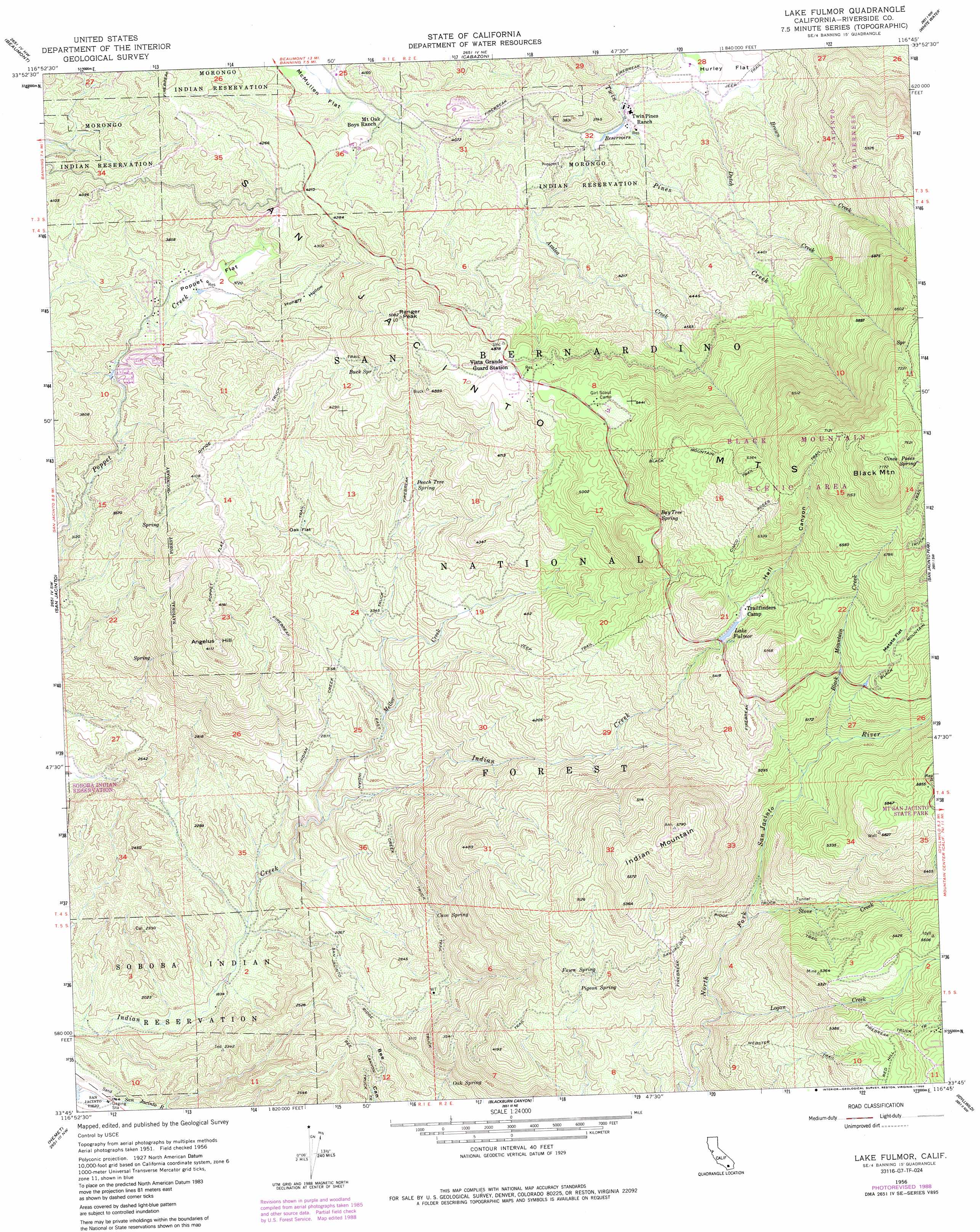
USGS Topo Quad 33116g7 - 1:24,000 scale
| Topo Map Name: | Lake Fulmor |
| USGS Topo Quad ID: | 33116g7 |
| Print Size: | ca. 21 1/4" wide x 27" high |
| Southeast Coordinates: | 33.75° N latitude / 116.75° W longitude |
| Map Center Coordinates: | 33.8125° N latitude / 116.8125° W longitude |
| U.S. State: | CA |
| Filename: | o33116g7.jpg |
| Download Map JPG Image: | Lake Fulmor topo map 1:24,000 scale |
| Map Type: | Topographic |
| Topo Series: | 7.5´ |
| Map Scale: | 1:24,000 |
| Source of Map Images: | United States Geological Survey (USGS) |
| Alternate Map Versions: |
Lake Fulmor CA 1956, updated 1957 Download PDF Buy paper map Lake Fulmor CA 1956, updated 1961 Download PDF Buy paper map Lake Fulmor CA 1956, updated 1973 Download PDF Buy paper map Lake Fulmor CA 1956, updated 1987 Download PDF Buy paper map Lake Fulmor CA 1956, updated 1988 Download PDF Buy paper map Lake Fulmor CA 1996, updated 1999 Download PDF Buy paper map Lake Fulmor CA 2012 Download PDF Buy paper map Lake Fulmor CA 2015 Download PDF Buy paper map |
| FStopo: | US Forest Service topo Lake Fulmor is available: Download FStopo PDF Download FStopo TIF |
1:24,000 Topo Quads surrounding Lake Fulmor
Yucaipa |
Forest Falls |
San Gorgonio Mountain |
Catclaw Flat |
Morongo Valley |
El Casco |
Beaumont |
Cabazon |
White Water |
Desert Hot Springs |
Lakeview |
San Jacinto |
Lake Fulmor |
San Jacinto Peak |
Palm Springs |
Winchester |
Hemet |
Blackburn Canyon |
Idyllwild |
Palm View Peak |
Bachelor Mountain |
Sage |
Cahuilla Mountain |
Anza |
Butterfly Peak |
> Back to 33116e1 at 1:100,000 scale
> Back to 33116a1 at 1:250,000 scale
> Back to U.S. Topo Maps home
Lake Fulmor topo map: Gazetteer
Lake Fulmor: Areas
Point View elevation 1528m 5013′Lake Fulmor: Dams
Hall Mill 826 Dam elevation 1625m 5331′Lake Fulmor: Flats
Hurley Flat elevation 1063m 3487′McMullen Flat elevation 1191m 3907′
Metate Flat elevation 1738m 5702′
Oak Flat elevation 1088m 3569′
Poppet Flat elevation 1087m 3566′
Lake Fulmor: Parks
Black Mountain Scenic Area elevation 2061m 6761′Lake Fulmor: Reservoirs
Lake Fulmor elevation 1625m 5331′Lake Fulmor: Springs
Bay Tree Spring elevation 1574m 5164′Buck Spring elevation 1379m 4524′
Cave Spring elevation 947m 3106′
Cinco Poses Spring elevation 2207m 7240′
Fawn Spring elevation 1360m 4461′
Oak Spring elevation 866m 2841′
Peach Tree Spring elevation 1175m 3854′
Pigeon Spring elevation 1293m 4242′
Lake Fulmor: Streams
Azalea Creek elevation 1057m 3467′Black Mountain Creek elevation 1403m 4603′
Ditch Creek elevation 1028m 3372′
Logan Creek elevation 1164m 3818′
Mellor Creek elevation 730m 2395′
Stone Creek elevation 1267m 4156′
Lake Fulmor: Summits
Angelus Hill elevation 1248m 4094′Black Mountain elevation 2369m 7772′
Indian Mountain elevation 1760m 5774′
Ranger Peak elevation 1530m 5019′
Lake Fulmor: Trails
Bee Canyon Truck Trail elevation 687m 2253′Black Mountain Trail elevation 1839m 6033′
Black Mountain Truck Trail elevation 2013m 6604′
Cinco Poses Trail elevation 1977m 6486′
Indian Creek Truck Trail elevation 969m 3179′
Poppet Flat Divide Truck Trail elevation 1241m 4071′
San Jacinto Ridge Truck Trail elevation 1415m 4642′
Lake Fulmor: Valleys
Hall Canyon elevation 1630m 5347′Hungry Hollow elevation 1102m 3615′
Lake Fulmor digital topo map on disk
Buy this Lake Fulmor topo map showing relief, roads, GPS coordinates and other geographical features, as a high-resolution digital map file on DVD: