Wrightsville Beach Topo Map North Carolina
To zoom in, hover over the map of Wrightsville Beach
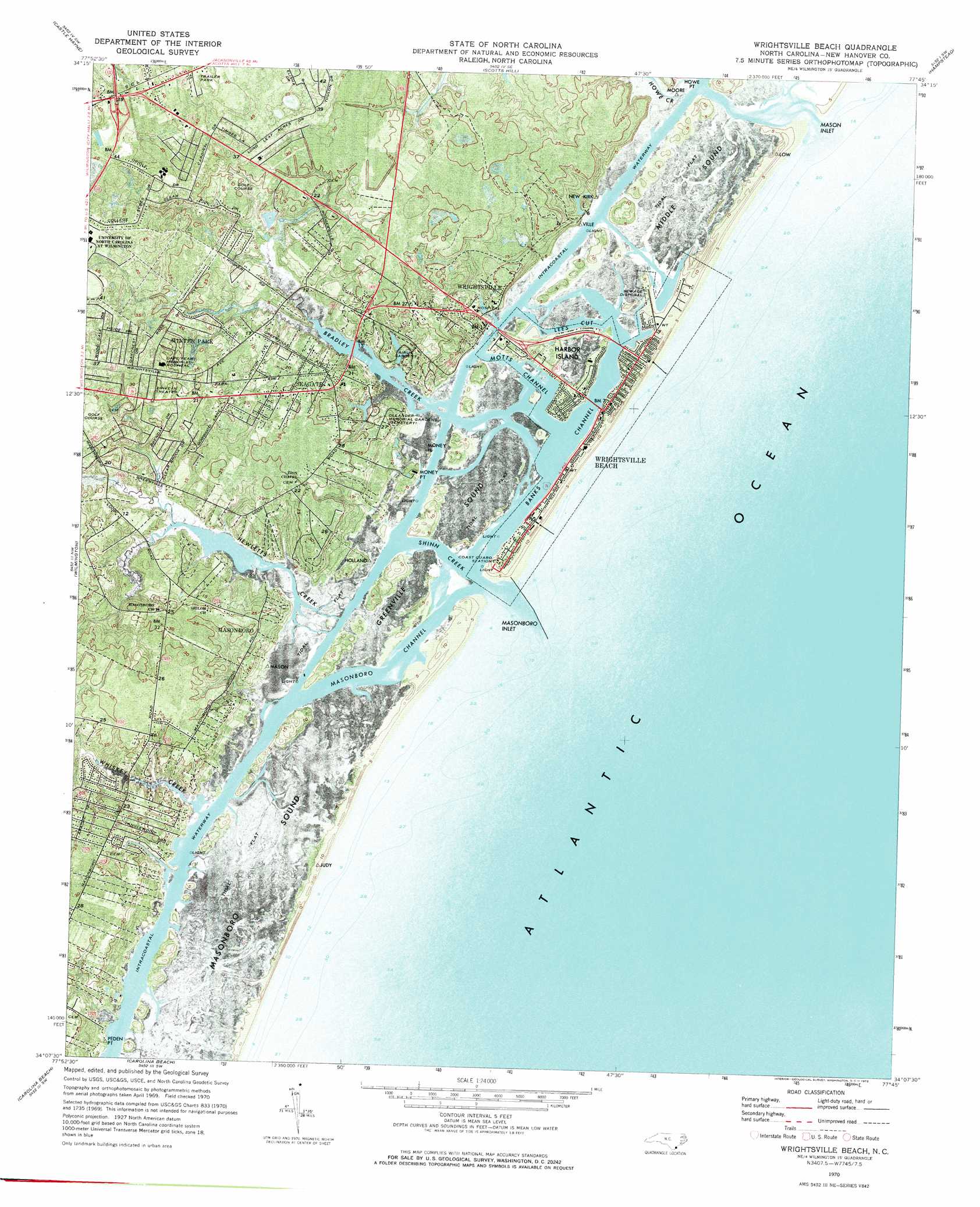
USGS Topo Quad 34077b7 - 1:24,000 scale
| Topo Map Name: | Wrightsville Beach |
| USGS Topo Quad ID: | 34077b7 |
| Print Size: | ca. 21 1/4" wide x 27" high |
| Southeast Coordinates: | 34.125° N latitude / 77.75° W longitude |
| Map Center Coordinates: | 34.1875° N latitude / 77.8125° W longitude |
| U.S. State: | NC |
| Filename: | p34077b7.jpg |
| Download Map JPG Image: | Wrightsville Beach topo map 1:24,000 scale |
| Map Type: | Orthophoto |
| Topo Series: | 7.5´ |
| Map Scale: | 1:24,000 |
| Source of Map Images: | United States Geological Survey (USGS) |
| Alternate Map Versions: |
Wrightsville Beach NC 1970, updated 1972 Download PDF Buy paper map Wrightsville Beach NC 1980, updated 1985 Download PDF Buy paper map Wrightsville Beach NC 1997, updated 2000 Download PDF Buy paper map Wrightsville Beach NC 2010 Download PDF Buy paper map Wrightsville Beach NC 2013 Download PDF Buy paper map Wrightsville Beach NC 2016 Download PDF Buy paper map |
1:24,000 Topo Quads surrounding Wrightsville Beach
Currie |
Rocky Point |
Mooretown |
Topsail |
Holly Ridge |
Leland |
Castle Hayne |
Scotts Hill |
Hampstead |
|
Winnabow |
Wilmington |
Wrightsville Beach |
||
Funston |
Carolina Beach |
|||
Southport |
Kure Beach |
> Back to 34077a1 at 1:100,000 scale
> Back to 34076a1 at 1:250,000 scale
> Back to U.S. Topo Maps home
Wrightsville Beach topo map: Gazetteer
Wrightsville Beach: Bays
Greenville Sound elevation 1m 3′Mason Inlet elevation 1m 3′
Masonboro Inlet elevation 0m 0′
Masonboro Sound elevation 0m 0′
Wrightsville Beach: Capes
Holland Point elevation 1m 3′Money Point elevation 2m 6′
Peden Point elevation 1m 3′
Shinn Point elevation 2m 6′
Wrightsville Beach: Channels
Banks Channel elevation 0m 0′Lees Cut elevation 0m 0′
Masonboro Channel elevation 0m 0′
Moore Inlet (historical) elevation 2m 6′
Motts Channel elevation 0m 0′
Wrightsville Beach: Guts
Shinn Creek elevation 0m 0′Wrightsville Beach: Islands
Harbor Island elevation 1m 3′Masonboro Island elevation 0m 0′
Money Island elevation 1m 3′
Wrightsville Beach: Parks
Airlie Gardens elevation 2m 6′Wrightsville Beach: Populated Places
Airlie elevation 2m 6′Bradley Creek East Estates elevation 4m 13′
Bradley Creek Point elevation 5m 16′
Bradley Park elevation 5m 16′
Camelot Mobile Park elevation 7m 22′
Cavalier Woods elevation 7m 22′
Channel Acres elevation 1m 3′
College Acres elevation 12m 39′
Colonial Village Mobile Home Park elevation 8m 26′
Driftwood Mobile Home Park elevation 8m 26′
Edgewater Estates elevation 6m 19′
Faircrest Mobile Home Park elevation 5m 16′
Greenville Village Mobile Home Park elevation 7m 22′
Kathy Anns Mobile Home Park elevation 8m 26′
Lee Acres Mobile Home Park elevation 7m 22′
Lions Gate elevation 8m 26′
Long Leaf Acres elevation 14m 45′
Masonboro elevation 8m 26′
Masonboro Mobile Home Park elevation 6m 19′
Melrose Mobile Home Park elevation 8m 26′
Millbrook elevation 6m 19′
Oakcrest elevation 5m 16′
Old Grove Mobile Home Park elevation 7m 22′
Parmele Isles elevation 2m 6′
Piner Mobile Home Park elevation 2m 6′
Piney Woods elevation 9m 29′
Potters Mobile Home Park elevation 7m 22′
Rosemans Mobile Home Park elevation 7m 22′
Seagate elevation 8m 26′
Shell Island elevation 2m 6′
Shore Acres elevation 2m 6′
Tanglewood elevation 7m 22′
Timberland Village Mobile Home Park elevation 6m 19′
Windemere elevation 9m 29′
Wrightsville elevation 4m 13′
Wrightsville Beach elevation 1m 3′
Wrightsville Beach: Post Offices
Wrightsville Beach Post Office elevation 2m 6′Wrightsville Beach: Streams
Bradley Creek elevation 0m 0′Hewletts Creek elevation 0m 0′
Whiskey Creek elevation 0m 0′
Wrightsville Beach: Trails
Apache Trail elevation 8m 26′Wrightsville Beach digital topo map on disk
Buy this Wrightsville Beach topo map showing relief, roads, GPS coordinates and other geographical features, as a high-resolution digital map file on DVD:
Atlantic Coast (NY, NJ, PA, DE, MD, VA, NC)
Buy digital topo maps: Atlantic Coast (NY, NJ, PA, DE, MD, VA, NC)
 map DVD")