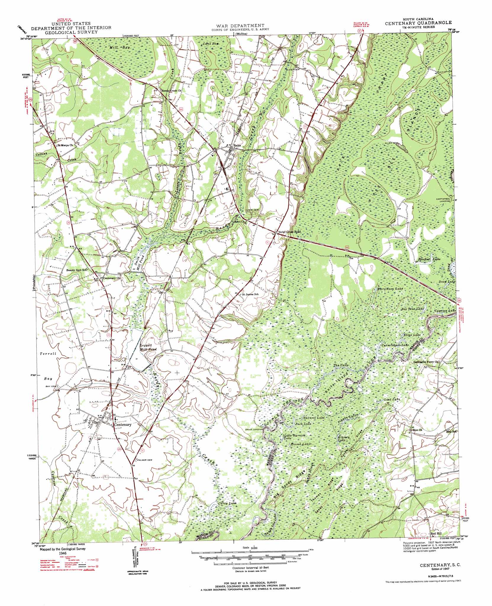
Centenary Topo Map South Carolina
To zoom in, hover over the map of Centenary
USGS Topo Quad 34079a3 - 1:24,000 scale
| Topo Map Name: | Centenary |
| USGS Topo Quad ID: | 34079a3 |
| Print Size: | ca. 21 1/4" wide x 27" high |
| Southeast Coordinates: | 34° N latitude / 79.25° W longitude |
| Map Center Coordinates: | 34.0625° N latitude / 79.3125° W longitude |
| U.S. State: | SC |
| Filename: | o34079a3.jpg |
| Download Map JPG Image: | Centenary topo map 1:24,000 scale |
| Map Type: | Topographic |
| Topo Series: | 7.5´ |
| Map Scale: | 1:24,000 |
| Source of Map Images: | United States Geological Survey (USGS) |
| Alternate Map Versions: |
Centenary SC 1947 Download PDF Buy paper map Centenary SC 1947 Download PDF Buy paper map Centenary SC 2011 Download PDF Buy paper map Centenary SC 2014 Download PDF Buy paper map |
1:24,000 Topo Quads surrounding Centenary
Oak Grove |
Latta |
Fork |
Lake View |
Fair Bluff |
Pee Dee |
Marion |
Mullins |
Nichols |
Duford |
Pamplico North |
Friendship |
Centenary |
Galivants Ferry |
Bayboro |
Pamplico South |
Gresham |
Britton Neck |
Horry |
Adrian |
Prospect Crossroads |
Johnsonville |
Snow Island |
Dongola |
Conway |
> Back to 34079a1 at 1:100,000 scale
> Back to 34078a1 at 1:250,000 scale
> Back to U.S. Topo Maps home
Centenary topo map: Gazetteer
Centenary: Dams
Baxley Farm Pond Dam D-0509 elevation 21m 68′Baxleys 501 Pond Dam D-0513 elevation 20m 65′
Leggett Millpond Dam D-0511 elevation 12m 39′
Rowell Pond Dam D-3239 elevation 13m 42′
Centenary: Falls
The Falls elevation 9m 29′Centenary: Guts
Old Dead River elevation 12m 39′Sandy Slough elevation 9m 29′
Centenary: Islands
Knife Island elevation 9m 29′Pee Dee Islands elevation 15m 49′
Centenary: Lakes
Barnett Lake elevation 9m 29′Bee Tree Lake elevation 8m 26′
Blocker Lake elevation 12m 39′
Carey Lake elevation 9m 29′
Carmichael Lake elevation 9m 29′
Cypress Lake elevation 9m 29′
Deep Lake elevation 11m 36′
Elvis Lake elevation 9m 29′
Haroldson Lake elevation 9m 29′
Jack Lake elevation 9m 29′
Kinney Lake elevation 9m 29′
Little Barnett Lake elevation 9m 29′
Liza Lake elevation 9m 29′
Pigpen Lakes elevation 9m 29′
Round Lake elevation 9m 29′
Sandy Isle Lake elevation 9m 29′
Centenary: Populated Places
Ariel Cross Road elevation 27m 88′Cartwheel Landing elevation 11m 36′
Centenary elevation 16m 52′
Davis Landing elevation 9m 29′
Pages (historical) elevation 12m 39′
Rains elevation 25m 82′
Centenary: Post Offices
Centenary Post Office elevation 15m 49′Rains Post Office elevation 24m 78′
Centenary: Reservoirs
Leggett Mill Pond elevation 12m 39′Smith Mill Pond elevation 13m 42′
Centenary: Ridges
Big Sandy Ridge elevation 9m 29′Cooper Ridge elevation 9m 29′
Sandy Ridge elevation 9m 29′
Thomas Ridge elevation 9m 29′
Centenary: Streams
Little Reedy Creek elevation 14m 45′Reedy Creek elevation 9m 29′
Savannah Creek elevation 10m 32′
Centenary: Swamps
Back Swamp elevation 12m 39′Centenary digital topo map on disk
Buy this Centenary topo map showing relief, roads, GPS coordinates and other geographical features, as a high-resolution digital map file on DVD:
South Carolina, Western North Carolina & Northeastern Georgia
Buy digital topo maps: South Carolina, Western North Carolina & Northeastern Georgia