Due West Topo Map South Carolina
To zoom in, hover over the map of Due West
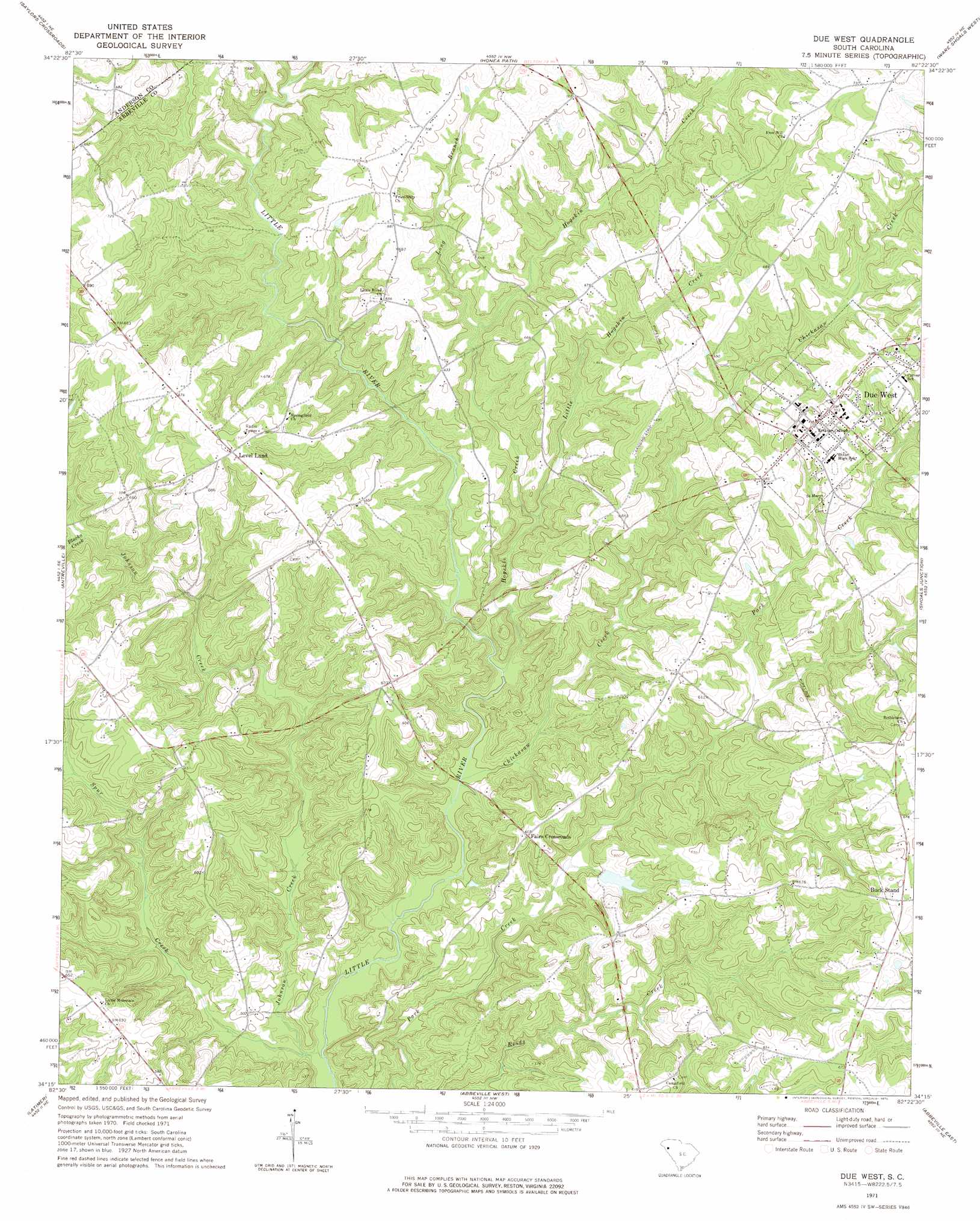
USGS Topo Quad 34082c4 - 1:24,000 scale
| Topo Map Name: | Due West |
| USGS Topo Quad ID: | 34082c4 |
| Print Size: | ca. 21 1/4" wide x 27" high |
| Southeast Coordinates: | 34.25° N latitude / 82.375° W longitude |
| Map Center Coordinates: | 34.3125° N latitude / 82.4375° W longitude |
| U.S. State: | SC |
| Filename: | o34082c4.jpg |
| Download Map JPG Image: | Due West topo map 1:24,000 scale |
| Map Type: | Topographic |
| Topo Series: | 7.5´ |
| Map Scale: | 1:24,000 |
| Source of Map Images: | United States Geological Survey (USGS) |
| Alternate Map Versions: |
Due West SC 1971, updated 1975 Download PDF Buy paper map Due West SC 2011 Download PDF Buy paper map Due West SC 2014 Download PDF Buy paper map |
1:24,000 Topo Quads surrounding Due West
Anderson North |
Belton West |
Belton East |
Fork Shoals |
Hickory Tavern |
Anderson South |
Saylors Crossroads |
Honea Path |
Ware Shoals West |
Ware Shoals East |
Iva |
Antreville |
Due West |
Shoals Junction |
Cokesbury |
Lowndesville |
Latimer |
Abbeville West |
Abbeville East |
Greenwood |
Heardmont |
Calhoun Falls |
Calhoun Creek |
Verdery |
Bradley |
> Back to 34082a1 at 1:100,000 scale
> Back to 34082a1 at 1:250,000 scale
> Back to U.S. Topo Maps home
Due West topo map: Gazetteer
Due West: Bridges
Fairs Bridge elevation 152m 498′Tucker Bridge elevation 156m 511′
Due West: Dams
South Carolina Noname 01003 D-3037 Dam elevation 173m 567′Due West: Parks
Erskine College-Due West Historic District elevation 209m 685′Due West: Populated Places
Buck Stand elevation 210m 688′Due West elevation 213m 698′
Fairs Crossroads elevation 185m 606′
Iris elevation 202m 662′
Level Land elevation 213m 698′
The Hook (historical) elevation 207m 679′
West View elevation 215m 705′
Winona elevation 226m 741′
Due West: Reservoirs
L R Powell Lake elevation 173m 567′Due West: Streams
Blacks Creek elevation 172m 564′Camp Creek elevation 176m 577′
Chickasaw Creek elevation 152m 498′
East Buckhorn Creek elevation 177m 580′
Hogskin Creek elevation 154m 505′
Johnson Creek elevation 144m 472′
Little Hogskin Creek elevation 161m 528′
Long Branch elevation 170m 557′
Spur Creek elevation 142m 465′
West Buckhorn Creek elevation 177m 580′
Due West digital topo map on disk
Buy this Due West topo map showing relief, roads, GPS coordinates and other geographical features, as a high-resolution digital map file on DVD:
South Carolina, Western North Carolina & Northeastern Georgia
Buy digital topo maps: South Carolina, Western North Carolina & Northeastern Georgia